TopoQuest Logo
Do you find TopoQuest useful?
Help keep TopoQuest running and adding new maps/features by donating!
Bitcoin:  19c7KJd3qBynnjoSw5npx9KScwjBe4ifkT
Litecoin:  LXs6TkuXGGXo1vDsWCkWVdjQX94eUKd6ui
Home View Maps Find Maps Find Places Resources & Links


Hedges, Kentucky Topographic Map

USGS Map Title: Hedges, KY
USGS Map MRC: 37084H1
DRG (GeoTIFF) Download: o37084h1.tif


Neighboring USGS Topographic Map Quads:


  Austerlitz, KY  
38084A2
 

  Sideview, KY  
38084A1
 

  Mount Sterling, KY  
38083A8
 

  Winchester, KY  
37084H2
 

  Hedges, KY  
37084H1
 

  Levee, KY  
37083H8
 

  Union City, KY  
37084G2
 

  Palmer, KY  
37084G1
 

  Clay City, KY  
37083G8


Map MRC Location:

N38°
W85°
N38°
W84°
H8 H7 H6 H5 H4 H3 H2 H1
G8 G7 G6 G5 G4 G3 G2 G1
F8 F7 F6 F5 F4 F3 F2 F1
E8 E7 E6 E5 E4 E3 E2 E1
D8 D7 D6 D5 D4 D3 D2 D1
C8 C7 C6 C5 C4 C3 C2 C1
B8 B7 B6 B5 B4 B3 B2 B1
A8 A7 A6 A5 A4 A3 A2 A1
N37°
W85°
N37°
W84°

Hedges, KY USGS 1:24K Topographic Map Preview:
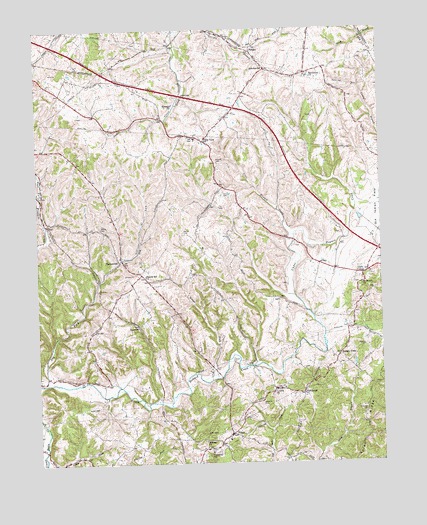
Hedges, KY USGS Topographic Map
Click on map above to begin viewing in our Map Viewer.

This topographic map contains these locations and features:
Feature Name Type Latitude Longitude GNIS ID View Map
Adams CemeteryCemeteryN37.9428°W84.1016°485768View Map
AgawamPopulated PlaceN37.9145°W84.0880°507378View Map
Agawam Flag Stop (historical)LocaleN37.9148°W84.0884°2508361View Map
Arlen Post Office (historical)Post OfficeN37.8754°W84.1192°2508360View Map
Bethlehem Baptist ChurchChurchN37.9870°W84.0246°487030View Map
Bloomingdale Post Office (historical)Post OfficeN37.8879°W84.1242°2508324View Map
Boones Creek Church CampLocaleN37.8955°W84.0400°2508526View Map
Chilton Post Office (historical)Post OfficeN37.9056°W84.0158°2508354View Map
Clark County Trapp Fire DepartmentBuildingN37.8829°W84.0543°2637124View Map
Corinth Baptist ChurchChurchN37.8959°W84.0385°490106View Map
Crow RidgeRidgeN37.9094°W84.0075°2508524View Map
Dawson CemeteryCemeteryN37.9084°W84.0058°490689View Map
Dry ForkStreamN37.8984°W84.1221°491196View Map
Dunaway Church CemeteryCemeteryN37.8785°W84.0629°2508357View Map
Dunaway Methodist ChurchChurchN37.8779°W84.0624°491281View Map
Dunaway Post Office (historical)Post OfficeN37.8790°W84.0629°2508358View Map
EdgewoodLocaleN37.9869°W84.0117°2508523View Map
El Bethel ChurchChurchN37.9259°W84.0069°491601View Map
Ephesus Baptist ChurchChurchN37.9784°W84.0746°491797View Map
Everman CemeteryCemeteryN37.8895°W84.0058°491851View Map
Fox CemeteryCemeteryN37.9487°W84.0585°492404View Map
Fox Railroad Station (historical)LocaleN37.9892°W84.1098°2508516View Map
FruitlandLocaleN37.9835°W84.0414°2508323View Map
Goffs CornerPopulated PlaceN37.9287°W84.0066°508104View Map
HedgesPopulated PlaceN37.9937°W84.0460°493997View Map
Hedges Post Office (historical)Post OfficeN37.9935°W84.0462°2508520View Map
Hedges Railroad Station (historical)LocaleN37.9956°W84.0449°2508521View Map
Irvin CemeteryCemeteryN37.9523°W84.0549°495020View Map
Kings ForkStreamN37.8990°W84.0621°495761View Map
Little Dry ForkStreamN37.9042°W84.1221°2508512View Map
Little Howard CreekStreamN37.9404°W84.0316°496757View Map
Midway (historical)Populated PlaceN37.8810°W84.0644°2508359View Map
Midway ChurchChurchN37.8812°W84.0646°498171View Map
MoundaleLocaleN37.9934°W84.0452°2508522View Map
Osborne CemeteryCemeteryN37.8917°W84.0438°500011View Map
Parrish CemeteryCemeteryN37.9409°W84.0713°500214View Map
Pharris Hill Christian ChurchChurchN37.9290°W84.0858°500510View Map
Pharris Store (historical)LocaleN37.9288°W84.0860°2508363View Map
Pilot ViewPopulated PlaceN37.9679°W84.0638°500654View Map
Pilot View Post Office (historical)Post OfficeN37.9689°W84.0633°2508353View Map
Pilot View SchoolSchoolN37.9685°W84.0671°2508518View Map
Pine RidgeRidgeN37.8834°W84.0058°500717View Map
Pleasant HillSummitN37.9800°W84.0992°2508517View Map
Pleasant RidgeRidgeN37.9709°W84.0690°2508519View Map
Rabbit TownPopulated PlaceN37.9059°W84.0152°508893View Map
Raker Railroad Station (historical)LocaleN37.9338°W84.1116°2508528View Map
RightanglePopulated PlaceN37.8948°W84.0285°508938View Map
Rightangle Post Office (historical)Post OfficeN37.8950°W84.0286°2508355View Map
Rose HillSummitN37.9434°W84.0846°2508365View Map
RuckervillePopulated PlaceN37.9337°W84.0944°502452View Map
Ruckerville Christian Church (historical)ChurchN37.9344°W84.0951°2508364View Map
Ruckerville Post Office (historical)Post OfficeN37.9336°W84.0957°2508362View Map
Rupard CemeteryCemeteryN37.9615°W84.0585°502474View Map
SchollsvillePopulated PlaceN37.9884°W84.0408°503047View Map
Snowden (historical)Populated PlaceN37.8924°W84.0396°2508525View Map
Southeast Clark DivisionCivilN37.9102°W84.0899°1936934View Map
TrappPopulated PlaceN37.8834°W84.0549°509229View Map
Trapp Elementary School (historical)SchoolN37.8818°W84.0561°2508356View Map
Trapp Post Office (historical)Post OfficeN37.8833°W84.0544°2508527View Map

Note: Coordinates in the location and feature list above are referenced to NAD83 datum.


Copyright (C) 2008-2024 Ryan Niemi / Sunset Dynamics ... All Rights Reserved