TopoQuest Logo
Do you find TopoQuest useful?
Help keep TopoQuest running and adding new maps/features by donating!
Bitcoin:  19c7KJd3qBynnjoSw5npx9KScwjBe4ifkT
Litecoin:  LXs6TkuXGGXo1vDsWCkWVdjQX94eUKd6ui
Home View Maps Find Maps Find Places Resources & Links


Headsville, West Virginia Topographic Map

USGS Map Title: Headsville, WV
USGS Map MRC: 39078D7
DRG (GeoTIFF) Download: o39078d7.tif


Neighboring USGS Topographic Map Quads:


  Lonaconing, MD  
39078E8
 

  Cresaptown, MD  
39078E7
 

  Patterson Creek, WV  
39078E6
 

  Keyser, WV  
39078D8
 

  Headsville, WV  
39078D7
 

  Springfield, WV  
39078D6
 

  Burlington, WV  
39078C8
 

  Romney, WV  
39078C7
 

  Augusta, WV  
39078C6


Map MRC Location:

N40°
W79°
N40°
W78°
H8 H7 H6 H5 H4 H3 H2 H1
G8 G7 G6 G5 G4 G3 G2 G1
F8 F7 F6 F5 F4 F3 F2 F1
E8 E7 E6 E5 E4 E3 E2 E1
D8 D7 D6 D5 D4 D3 D2 D1
C8 C7 C6 C5 C4 C3 C2 C1
B8 B7 B6 B5 B4 B3 B2 B1
A8 A7 A6 A5 A4 A3 A2 A1
N39°
W79°
N39°
W78°

Headsville, WV USGS 1:24K Topographic Map Preview:
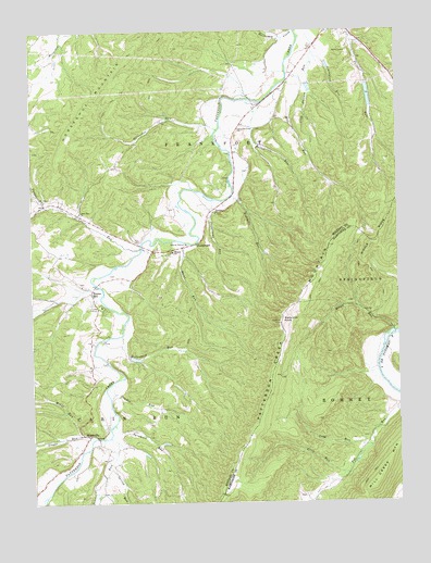
Headsville, WV USGS Topographic Map
Click on map above to begin viewing in our Map Viewer.

This topographic map contains these locations and features:
Feature Name Type Latitude Longitude GNIS ID View Map
Allen RunStreamN39.3826°W78.7675°1534888View Map
Beaver RunStreamN39.3923°W78.8489°1535456View Map
Broad RunStreamN39.4198°W78.7514°1536368View Map
Broad Run GraveyardCemeteryN39.4280°W78.7652°2726556View Map
Cabin RunStreamN39.4429°W78.8381°1536839View Map
Cabin Run ChurchChurchN39.4520°W78.8584°1536842View Map
Camp MincoLocaleN39.4270°W78.8511°1536935View Map
Carr CemeteryCemeteryN39.4848°W78.7870°1936845View Map
ChampwoodPopulated PlaceN39.4434°W78.8192°1554107View Map
Davis School (historical)SchoolN39.4737°W78.8042°1557039View Map
Dowden RunStreamN39.4065°W78.8486°1538303View Map
Eusebia ChurchChurchN39.4518°W78.8120°1538751View Map
Eusiva CemeteryCemeteryN39.4518°W78.8114°1937341View Map
Fort Ashby Census Designated PlaceCensusN39.4966°W78.7631°2389101View Map
Fox Farm SpringSpringN39.3837°W78.7634°1677915View Map
Graveyard RunStreamN39.4943°W78.7778°1539650View Map
Greenwall CemeteryCemeteryN39.4106°W78.8495°1937351View Map
Hazel RunStreamN39.4440°W78.8222°1540097View Map
HeadsvillePopulated PlaceN39.3926°W78.8559°1554672View Map
Headsville BridgeBridgeN39.3920°W78.8528°2647252View Map
Headsville CemeteryCemeteryN39.4329°W78.8578°1937354View Map
Hollenbeck RunStreamN39.4193°W78.8445°1540387View Map
Horseshoe MountainSummitN39.4854°W78.8494°1540515View Map
Horseshoe RunStreamN39.4737°W78.8106°1540516View Map
Horseshoe School (historical)SchoolN39.4720°W78.8370°1557047View Map
Kellar RunStreamN39.4809°W78.7959°1541122View Map
Long RunStreamN39.3893°W78.7595°1542411View Map
Mikes RunStreamN39.3932°W78.8592°1543249View Map
Mill RunStreamN39.4887°W78.7867°1543350View Map
Mineral Baptist CemeteryCemeteryN39.4415°W78.8261°1937379View Map
Mineral ChurchChurchN39.4415°W78.8270°1543435View Map
Ochre RunStreamN39.4570°W78.8731°1544324View Map
Painter School (historical)SchoolN39.4823°W78.7597°1717895View Map
Pargut RunStreamN39.4598°W78.8747°1544571View Map
Patterson Creek ChurchChurchN39.4740°W78.8039°1544624View Map
Patterson Creek Structure 36 DamDamN39.4184°W78.8681°1559099View Map
Patterson Creek Structure 37 DamDamN39.4284°W78.8697°1559100View Map
Patterson Creek Structure 38 DamDamN39.4151°W78.8414°1559101View Map
Patterson Creek Structure 44 DamDamN39.4851°W78.7797°1559102View Map
Patterson Creek Structure 45 DamDamN39.4918°W78.7731°1559103View Map
Patterson Creek Structure 46 DamDamN39.4851°W78.7597°1559104View Map
Reece CemeteryCemeteryN39.4629°W78.8006°1937388View Map
Reeses MillPopulated PlaceN39.4307°W78.8547°1555461View Map
Reeves CemeteryCemeteryN39.4559°W78.8706°1937389View Map
Rinehart RunStreamN39.4565°W78.8064°1545752View Map
Slate Lick KnobSummitN39.4226°W78.7900°1555644View Map
Slaty Lick Knob Lookout TowerLocaleN39.4223°W78.7900°1717915View Map
Spring RunStreamN39.3848°W78.8492°1547216View Map
Staggs RunStreamN39.3920°W78.8547°1547317View Map
Sugarcamp RunStreamN39.4554°W78.8122°1547688View Map
Sycamore RunStreamN39.3957°W78.8472°1547847View Map
Sycamore School (historical)SchoolN39.4509°W78.8136°1557060View Map
Van Meter CemeteryCemeteryN39.4840°W78.7997°1937408View Map
West Virginia State Police Troop 2 - Keyser DetachmentBuildingN39.4504°W78.8550°2728059View Map
WJJB-FM (Romney)TowerN39.4223°W78.7900°1559837View Map

Note: Coordinates in the location and feature list above are referenced to NAD83 datum.


Copyright (C) 2008-2024 Ryan Niemi / Sunset Dynamics ... All Rights Reserved