TopoQuest Logo
Do you find TopoQuest useful?
Help keep TopoQuest running and adding new maps/features by donating!
Bitcoin:  19c7KJd3qBynnjoSw5npx9KScwjBe4ifkT
Litecoin:  LXs6TkuXGGXo1vDsWCkWVdjQX94eUKd6ui
Home View Maps Find Maps Find Places Resources & Links


Hattieville, Arkansas Topographic Map

USGS Map Title: Hattieville, AR
USGS Map MRC: 35092C7
DRG (GeoTIFF) Download: o35092c7.tif


Neighboring USGS Topographic Map Quads:


  Hector, AR  
35092D8
 

  Jerusalem, AR  
35092D7
 

  Cleveland, AR  
35092D6
 

  Moreland, AR  
35092C8
 

  Hattieville, AR  
35092C7
 

  Solgohachia, AR  
35092C6
 

  Atkins, AR  
35092B8
 

  Morrilton West, AR  
35092B7
 

  Morrilton East, AR  
35092B6


Map MRC Location:

N36°
W93°
N36°
W92°
H8 H7 H6 H5 H4 H3 H2 H1
G8 G7 G6 G5 G4 G3 G2 G1
F8 F7 F6 F5 F4 F3 F2 F1
E8 E7 E6 E5 E4 E3 E2 E1
D8 D7 D6 D5 D4 D3 D2 D1
C8 C7 C6 C5 C4 C3 C2 C1
B8 B7 B6 B5 B4 B3 B2 B1
A8 A7 A6 A5 A4 A3 A2 A1
N35°
W93°
N35°
W92°

Hattieville, AR USGS 1:24K Topographic Map Preview:
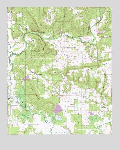
Hattieville, AR USGS Topographic Map
Click on map above to begin viewing in our Map Viewer.

This topographic map contains these locations and features:
Feature Name Type Latitude Longitude GNIS ID View Map
Beeson CemeteryCemeteryN35.3054°W92.8413°46337View Map
Boltman CemeteryCemeteryN35.3462°W92.7860°46825View Map
Boyd MountainSummitN35.2798°W92.8224°57421View Map
Bunker MountainSummitN35.2870°W92.8379°57470View Map
Burnetts BridgeBridgeN35.3240°W92.8727°47201View Map
Canady BranchStreamN35.3473°W92.7721°70980View Map
Cargile LakeReservoirN35.2751°W92.8148°81255View Map
Cargile Lake DamDamN35.2717°W92.8185°81254View Map
Cedar BranchStreamN35.3484°W92.8107°71054View Map
Childers CemeteryCemeteryN35.3126°W92.8671°47739View Map
Cleaver CemeteryCemeteryN35.3226°W92.7663°47844View Map
Cooks CemeteryCemeteryN35.2795°W92.7996°47985View Map
Devils CreekStreamN35.2870°W92.8643°76789View Map
Devils KnobSummitN35.3501°W92.8332°57648View Map
Dunham CemeteryCemeteryN35.3537°W92.7521°48706View Map
Earl BrakeSwampN35.2653°W92.7712°48737View Map
East Fork Point Remove Site 11 DamDamN35.2834°W92.7602°79811View Map
East Fork Point Remove Site 11 ReservoirReservoirN35.2821°W92.7609°79812View Map
Goose PondSwampN35.2680°W92.8539°49513View Map
Granny HollowValleyN35.3492°W92.8296°71801View Map
Grinnel PondSwampN35.2864°W92.8577°49683View Map
Gum Log CreekStreamN35.2859°W92.8713°77090View Map
Hackers BridgeBridgeN35.3301°W92.8691°49750View Map
Hackers CreekStreamN35.3270°W92.8696°77100View Map
Happy BendPopulated PlaceN35.2640°W92.8674°57879View Map
HattievillePopulated PlaceN35.2876°W92.7868°57898View Map
Hattieville Post OfficePost OfficeN35.2879°W92.7871°84363View Map
Isabell CreekStreamN35.3359°W92.8710°72154View Map
MacedoniaPopulated PlaceN35.3309°W92.7627°58110View Map
Mount Vernon CemeteryCemeteryN35.3309°W92.8185°52425View Map
Mount Zion School (historical)SchoolN35.3120°W92.8538°75268View Map
New Mount Zion ChurchChurchN35.3709°W92.7524°52726View Map
Nichols Church (historical)ChurchN35.3604°W92.8649°62121View Map
Old HickoryPopulated PlaceN35.3267°W92.8029°58301View Map
Old Hickory Gas FieldOilfieldN35.3251°W92.7927°66210View Map
Pigeon Roost MountainSummitN35.3156°W92.7799°77996View Map
Plainview ChurchChurchN35.3609°W92.8285°53515View Map
Pool Hollow BranchStreamN35.2565°W92.7735°53686View Map
Prim BridgeBridgeN35.2815°W92.8627°53800View Map
RobertsvillePopulated PlaceN35.3679°W92.7902°58503View Map
Rocky BranchStreamN35.3390°W92.7763°54130View Map
Taw BranchStreamN35.3390°W92.7729°55454View Map
Township of GregoryCivilN35.2774°W92.7988°66438View Map
Township of Old HickoryCivilN35.3286°W92.8107°66446View Map
West Fork Point Remove Creek Site 12 DamDamN35.3484°W92.8135°79827View Map
West Fork Point Remove Creek Site 12 ReservoirReservoirN35.3504°W92.8117°79828View Map
West Fork Point Remove Creek Site 13 DamDamN35.3501°W92.7668°79829View Map
West Fork Point Remove Creek Site 13 ReservoirReservoirN35.3506°W92.7631°79830View Map
West Fork Point Remove Creek Site 14 DamDamN35.3451°W92.7602°79831View Map
West Fork Point Remove Creek Site 14 ReservoirReservoirN35.3452°W92.7573°79832View Map
West Fork Point Remove Creek Site 15 DamDamN35.3317°W92.7785°79833View Map
West Fork Point Remove Creek Site 15 ReservoirReservoirN35.3319°W92.7769°79834View Map
West Fork Point Remove Creek Site 16 DamDamN35.3034°W92.8552°79835View Map
West Fork Point Remove Creek Site 16 ReservoirReservoirN35.3055°W92.8524°79836View Map
Wiedower CemeteryCemeteryN35.2820°W92.8018°56343View Map
Wiedower MountainSummitN35.3101°W92.8227°58882View Map
Wildcat MountainSummitN35.3317°W92.8285°78774View Map
Wilson CemeteryCemeteryN35.2817°W92.7515°56435View Map
Zion Hill ChurchChurchN35.3090°W92.8377°56647View Map

Note: Coordinates in the location and feature list above are referenced to NAD83 datum.


Copyright (C) 2008-2024 Ryan Niemi / Sunset Dynamics ... All Rights Reserved