TopoQuest Logo
Do you find TopoQuest useful?
Help keep TopoQuest running and adding new maps/features by donating!
Bitcoin:  19c7KJd3qBynnjoSw5npx9KScwjBe4ifkT
Litecoin:  LXs6TkuXGGXo1vDsWCkWVdjQX94eUKd6ui
Home View Maps Find Maps Find Places Resources & Links


Harris Park, Wyoming Topographic Map

USGS Map Title: Harris Park, WY
USGS Map MRC: 42105C3
DRG (GeoTIFF) Download: o42105c3.tif


Neighboring USGS Topographic Map Quads:


  Braae, WY  
42105D4
 

  Esterbrook, WY  
42105D3
 

  Spring Creek, WY  
42105D2
 

  Laramie Peak, WY  
42105C4
 

  Harris Park, WY  
42105C3
 

  Cottonwood Falls, WY  
42105C2
 

  South Mountain, WY  
42105B4
 

  Fletcher Park, WY  
42105B3
 

  Johnson Mountain, WY  
42105B2


Map MRC Location:

N43°
W106°
N43°
W105°
H8 H7 H6 H5 H4 H3 H2 H1
G8 G7 G6 G5 G4 G3 G2 G1
F8 F7 F6 F5 F4 F3 F2 F1
E8 E7 E6 E5 E4 E3 E2 E1
D8 D7 D6 D5 D4 D3 D2 D1
C8 C7 C6 C5 C4 C3 C2 C1
B8 B7 B6 B5 B4 B3 B2 B1
A8 A7 A6 A5 A4 A3 A2 A1
N42°
W106°
N42°
W105°

Harris Park, WY USGS 1:24K Topographic Map Preview:
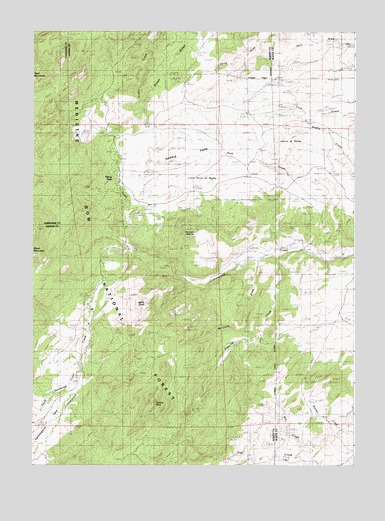
Harris Park, WY USGS Topographic Map
Click on map above to begin viewing in our Map Viewer.

This topographic map contains these locations and features:
Feature Name Type Latitude Longitude GNIS ID View Map
Albany PeakSummitN42.2689°W105.3283°1597701View Map
Ballard RanchLocaleN42.3022°W105.3136°1597904View Map
BinfordPopulated PlaceN42.3333°W105.3430°1598189View Map
Bromley SchoolSchoolN42.3222°W105.3122°1598384View Map
Donaldson RanchLocaleN42.2647°W105.2622°1599293View Map
Elliott PointSummitN42.3030°W105.3233°1604604View Map
Fall CreekStreamN42.3130°W105.3353°1599658View Map
Fall CreekStreamN42.3130°W105.3353°1599659View Map
Hagemeisters Twin Pine Ranch Airport (historical)AirportN42.3330°W105.2925°1605632View Map
Hanks SchoolSchoolN42.2777°W105.3550°1600194View Map
Harmon HeightsSummitN42.3172°W105.3144°1600216View Map
Harris ParkFlatN42.3369°W105.3178°1600220View Map
Laramie Peak Fire Zone Fire DepartmentBuildingN42.2959°W105.3526°2673584View Map
Laramie Peak Scout CampLocaleN42.3289°W105.3478°1605039View Map
Lewis RanchLocaleN42.3100°W105.2553°1600903View Map
Mill CreekStreamN42.2550°W105.2647°1601446View Map
North Cottonwood CreekStreamN42.2775°W105.3564°1601731View Map
Point of RocksPopulated PlaceN42.3422°W105.2778°1602219View Map
Preacher CreekStreamN42.3116°W105.2811°1602304View Map
Sutherland RanchLocaleN42.2858°W105.2989°1603467View Map
White RanchLocaleN42.2911°W105.3530°1604144View Map

Note: Coordinates in the location and feature list above are referenced to NAD83 datum.


Copyright (C) 2008-2024 Ryan Niemi / Sunset Dynamics ... All Rights Reserved