TopoQuest Logo
Do you find TopoQuest useful?
Help keep TopoQuest running and adding new maps/features by donating!
Bitcoin:  19c7KJd3qBynnjoSw5npx9KScwjBe4ifkT
Litecoin:  LXs6TkuXGGXo1vDsWCkWVdjQX94eUKd6ui
Home View Maps Find Maps Find Places Resources & Links


Hanging Rock, North Carolina Topographic Map

USGS Map Title: Hanging Rock, NC
USGS Map MRC: 36080D3
DRG (GeoTIFF) Download: o36080d3.tif


Neighboring USGS Topographic Map Quads:


  Claudville, VA  
36080E4
 

  Stuart SE, VA  
36080E3
 

  Nettleridge, VA  
36080E2
 

  Pilot Mountain, NC  
36080D4
 

  Hanging Rock, NC  
36080D3
 

  Danbury, NC  
36080D2
 

  Pinnacle, NC  
36080C4
 

  King, NC  
36080C3
 

  Walnut Cove, NC  
36080C2


Map MRC Location:

N37°
W81°
N37°
W80°
H8 H7 H6 H5 H4 H3 H2 H1
G8 G7 G6 G5 G4 G3 G2 G1
F8 F7 F6 F5 F4 F3 F2 F1
E8 E7 E6 E5 E4 E3 E2 E1
D8 D7 D6 D5 D4 D3 D2 D1
C8 C7 C6 C5 C4 C3 C2 C1
B8 B7 B6 B5 B4 B3 B2 B1
A8 A7 A6 A5 A4 A3 A2 A1
N36°
W81°
N36°
W80°

Hanging Rock, NC USGS 1:24K Topographic Map Preview:
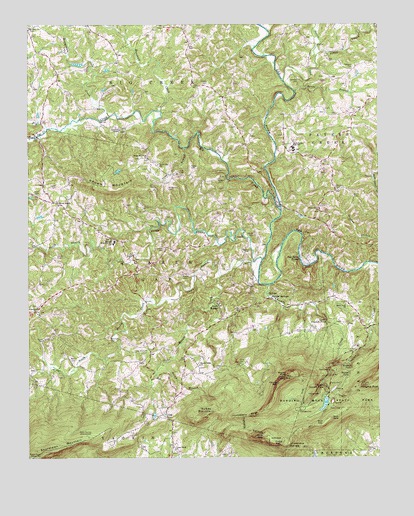
Hanging Rock, NC USGS Topographic Map
Click on map above to begin viewing in our Map Viewer.

This topographic map contains these locations and features:
Feature Name Type Latitude Longitude GNIS ID View Map
Baden School (historical)SchoolN36.4476°W80.3051°1952639View Map
Balanced RockSummitN36.3985°W80.2817°1006099View Map
Beaverdam CreekStreamN36.4737°W80.3456°980856View Map
Big CreekStreamN36.4465°W80.2848°981380View Map
Big Creek Primitive Baptist ChurchChurchN36.4987°W80.3745°981382View Map
Bonds BranchStreamN36.4807°W80.2795°981708View Map
Bondurant CemeteryCemeteryN36.4532°W80.3251°981710View Map
Brown MountainPopulated PlaceN36.4486°W80.3640°2681278View Map
Brown MountainSummitN36.4540°W80.3392°982018View Map
Brown Mountain Missionary Baptist ChurchChurchN36.4482°W80.3639°982019View Map
Brown Mountain SchoolSchoolN36.4596°W80.3287°982020View Map
Bullin CemeteryCemeteryN36.4507°W80.2587°982228View Map
Camp CreekStreamN36.3971°W80.2701°1952654View Map
Camp RetreatLocaleN36.3757°W80.2734°982547View Map
Cascade CreekStreamN36.4249°W80.2889°982717View Map
Cascade TrailTrailN36.3951°W80.2684°982722View Map
Cedar Falls ChurchChurchN36.4190°W80.2617°982826View Map
Closer Walk ChurchChurchN36.3774°W80.3228°983295View Map
Cole Gap MountainSummitN36.3865°W80.2670°1952658View Map
Cooks WallCliffN36.3787°W80.2876°983478View Map
Cooks Wall MountainSummitN36.3790°W80.2876°1952659View Map
Cooks Wall TrailTrailN36.3840°W80.2734°983479View Map
Cool GapGapN36.3804°W80.2889°983482View Map
Dan River ShoresPopulated PlaceN36.4326°W80.2770°1019901View Map
Devils ChimneySummitN36.3812°W80.2914°984142View Map
Flat Top CemeteryCemeteryN36.4168°W80.3006°985197View Map
Flippin CemeteryCemeteryN36.4832°W80.3106°985226View Map
Forest CemeteryCemeteryN36.4535°W80.3645°985269View Map
Frye CemeteryCemeteryN36.4576°W80.3212°985475View Map
GapLocaleN36.3868°W80.3253°985537View Map
George CemeteryCemeteryN36.4393°W80.2942°985626View Map
Hanging RockPillarN36.3960°W80.2562°986358View Map
Hanging Rock Park LakeReservoirN36.3907°W80.2692°1000579View Map
Hanging Rock Park Lake DamDamN36.3918°W80.2698°1000580View Map
Hanging Rock State ParkParkN36.3915°W80.2662°986363View Map
Hanging Rock TrailTrailN36.3932°W80.2609°986364View Map
Hidden FallsFallsN36.3990°W80.2605°986730View Map
Hoover Whitts Store SiteLocaleN36.4404°W80.2845°1007873View Map
House RockSummitN36.3790°W80.2814°1020850View Map
Huckleberry RidgeRidgeN36.3868°W80.2967°987208View Map
Indian FaceCliffN36.3982°W80.2778°1006098View Map
Keaton CemeteryCemeteryN36.4279°W80.3195°987880View Map
Kings Mountain View ChurchChurchN36.4615°W80.3320°988008View Map
Kiser DamDamN36.3885°W80.3298°1000576View Map
Kiser LakeReservoirN36.3874°W80.3300°1000575View Map
Lankford CemeteryCemeteryN36.4843°W80.2778°988143View Map
Little CreekStreamN36.4907°W80.2723°988613View Map
Long BranchStreamN36.4643°W80.3189°988918View Map
Lower Cascade FallsFallsN36.4149°W80.2686°989091View Map
Marshall CemeteryCemeteryN36.4093°W80.3459°989379View Map
Marshall CreekStreamN36.4751°W80.3281°989382View Map
Martin CemeteryCemeteryN36.4037°W80.3601°989394View Map
Martin CemeteryCemeteryN36.4121°W80.2720°989395View Map
Matthew Moore House (historical)LocaleN36.4349°W80.2920°1007874View Map
Mineral Springs Resort AreaLocaleN36.4204°W80.2878°1007876View Map
Moores KnobSummitN36.3982°W80.2828°990204View Map
Moores Knob TrailTrailN36.3957°W80.2770°990205View Map
Moores SpringsPopulated PlaceN36.4212°W80.2889°1027430View Map
Moores WallCliffN36.3965°W80.2864°990207View Map
Nelson CemeteryCemeteryN36.4532°W80.2653°990907View Map
North Double CreekStreamN36.4321°W80.2917°991215View Map
North Stokes High SchoolSchoolN36.4646°W80.2801°991274View Map
Nunn CemeteryCemeteryN36.4512°W80.3720°991328View Map
Old Orchard CemeteryCemeteryN36.4065°W80.3328°991591View Map
Peters CreekStreamN36.4840°W80.2837°992087View Map
Pinch Gut CreekStreamN36.4701°W80.3678°992224View Map
Piney Grove Primitive Baptist ChurchChurchN36.4462°W80.2706°992368View Map
Ray CemeteryCemeteryN36.4935°W80.3176°993077View Map
Reynolds Memorial SchoolSchoolN36.4376°W80.3439°993258View Map
Rierson CemeteryCemeteryN36.4549°W80.3076°993349View Map
Rock House Primitive Baptist ChurchChurchN36.4185°W80.3714°993520View Map
Rocky BranchStreamN36.4021°W80.3276°993567View Map
Rodgers CemeteryCemeteryN36.4879°W80.2589°993634View Map
Ruben MountainSummitN36.3871°W80.3123°993795View Map
Sertoma 4-H Educational CenterLocaleN36.4187°W80.3067°2681483View Map
Simmons CemeteryCemeteryN36.4354°W80.3264°994838View Map
Simmons ChapelChurchN36.4699°W80.3423°994841View Map
Smith CemeteryCemeteryN36.4332°W80.3645°994952View Map
South Double CreekStreamN36.4254°W80.2928°995140View Map
Stoney Ridge Baptist ChurchChurchN36.4018°W80.3142°995547View Map
The Rockhouse (historical)LocaleN36.4046°W80.3617°1007875View Map
Thore CemeteryCemeteryN36.4090°W80.3695°996062View Map
Tory FallsFallsN36.4015°W80.2981°1006097View Map
Township of Quaker GapCivilN36.4296°W80.3678°1027206View Map
Tucker CemeteryCemeteryN36.4582°W80.3164°996297View Map
Upper Cascade FallsFallsN36.3959°W80.2696°996549View Map
Vade Mecum (historical)LocaleN36.4187°W80.3067°1023057View Map
Vade Mecum CreekStreamN36.4276°W80.3062°996568View Map
Vaden CemeteryCemeteryN36.4343°W80.2959°996569View Map
Vaden QuarryMineN36.4264°W80.2606°2649383View Map
Window FallsFallsN36.4010°W80.2596°997475View Map
Witherow DamDamN36.4585°W80.3414°1000654View Map
Witherow LakeReservoirN36.4579°W80.3426°1000655View Map
WJTM-TV (Winston-Salem)TowerN36.3771°W80.3692°1018609View Map
Wolf GapGapN36.3843°W80.2714°997528View Map
Wolf RockSummitN36.3865°W80.2670°997543View Map
WUNL-TV (Winston-Salem)TowerN36.3762°W80.3703°1018608View Map
WXII-TV (Winston-Salem)TowerN36.3754°W80.3739°1018607View Map

Note: Coordinates in the location and feature list above are referenced to NAD83 datum.


Copyright (C) 2008-2024 Ryan Niemi / Sunset Dynamics ... All Rights Reserved