TopoQuest Logo
Do you find TopoQuest useful?
Help keep TopoQuest running and adding new maps/features by donating!
Bitcoin:  19c7KJd3qBynnjoSw5npx9KScwjBe4ifkT
Litecoin:  LXs6TkuXGGXo1vDsWCkWVdjQX94eUKd6ui
Home View Maps Find Maps Find Places Resources & Links


Hahatonka, Missouri Topographic Map

USGS Map Title: Hahatonka, MO
USGS Map MRC: 37092H7
DRG (GeoTIFF) Download: o37092h7.tif


Neighboring USGS Topographic Map Quads:


  Barnumton, MO  
38092A8
 

  Green Bay Terrace, MO  
38092A7
 

  Camdenton, MO  
38092A6
 

  Macks Creek, MO  
37092H8
 

  Hahatonka, MO  
37092H7
 

  Decaturville, MO  
37092H6
 

  Leadmine, MO  
37092G8
 

  Eldridge West, MO  
37092G7
 

  Eldridge East, MO  
37092G6


Map MRC Location:

N38°
W93°
N38°
W92°
H8 H7 H6 H5 H4 H3 H2 H1
G8 G7 G6 G5 G4 G3 G2 G1
F8 F7 F6 F5 F4 F3 F2 F1
E8 E7 E6 E5 E4 E3 E2 E1
D8 D7 D6 D5 D4 D3 D2 D1
C8 C7 C6 C5 C4 C3 C2 C1
B8 B7 B6 B5 B4 B3 B2 B1
A8 A7 A6 A5 A4 A3 A2 A1
N37°
W93°
N37°
W92°

Hahatonka, MO USGS 1:24K Topographic Map Preview:
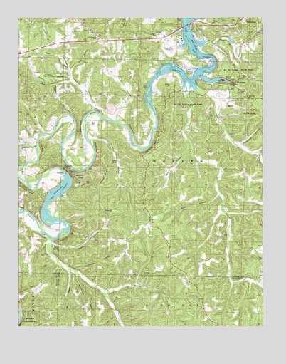
Hahatonka, MO USGS Topographic Map
Click on map above to begin viewing in our Map Viewer.

This topographic map contains these locations and features:
Feature Name Type Latitude Longitude GNIS ID View Map
Baker BluffCliffN37.9561°W92.8444°738263View Map
Baker CemeteryCemeteryN37.9573°W92.8380°713562View Map
Bank BranchStreamN37.9695°W92.7902°713615View Map
Bank Branch SchoolSchoolN37.9242°W92.7713°729701View Map
Bear HollowValleyN37.9270°W92.7741°713818View Map
Bell HollowValleyN37.9748°W92.8477°713914View Map
Berry BluffCliffN37.8761°W92.8732°713990View Map
Berry Bluff State Hunting AreaLocaleN37.8775°W92.8694°743406View Map
Big Niangua ChurchChurchN37.9936°W92.8355°742228View Map
Black SinkBasinN37.9700°W92.7616°738267View Map
Broadus BranchStreamN37.9353°W92.8730°714730View Map
Brush CreekStreamN37.9533°W92.8628°714840View Map
Brushy CreekStreamN37.8881°W92.8319°714886View Map
Byler SchoolSchoolN37.9673°W92.8371°715160View Map
Cave HollowValleyN37.9789°W92.8491°738272View Map
Clark HollowValleyN37.8786°W92.8257°715884View Map
Darby BluffCliffN37.9473°W92.8346°738262View Map
Deers Leap HillSummitN37.9759°W92.7699°738269View Map
Devils KitchenBasinN37.9709°W92.7646°738266View Map
Dickerson CemeteryCemeteryN37.8959°W92.8113°742217View Map
Dry HollowValleyN37.9881°W92.7752°717128View Map
Green Gables (historical)Populated PlaceN37.9498°W92.8746°740045View Map
Green Gables LodgeLocaleN37.9511°W92.8732°718789View Map
Ha Ha Tonka State ParkParkN37.9689°W92.7691°742224View Map
HahatonkaPopulated PlaceN37.9731°W92.7691°740897View Map
Hahatonka CastleLocaleN37.9759°W92.7702°718975View Map
Hahatonka Natural BridgeArchN37.9742°W92.7633°739029View Map
Hanes FlatFlatN37.9750°W92.8605°738274View Map
Jackson HollowValleyN37.9759°W92.8480°738273View Map
Jarvis HollowValleyN37.9989°W92.7805°720266View Map
Jim HollowValleyN37.9781°W92.8485°738271View Map
Kirkland BluffCliffN37.9120°W92.8505°720647View Map
Lake NianguaReservoirN37.9384°W92.8519°758317View Map
Lake Valley Country ClubLocaleN37.9878°W92.7999°742227View Map
Laughlin CemeteryCemeteryN37.9922°W92.8035°720832View Map
Little Brush CreekStreamN37.9533°W92.8641°721174View Map
Lodge CemeteryCemeteryN37.9642°W92.7691°742223View Map
Mash HollowValleyN37.8961°W92.8488°721950View Map
Mead CampLocaleN37.9275°W92.8527°722178View Map
Meades BluffCliffN37.9375°W92.8494°738258View Map
Mid - County Fire Protection District Station 6BuildingN37.9380°W92.8104°2620647View Map
Mills CemeteryCemeteryN37.8995°W92.8624°742216View Map
Mills SpringSpringN37.9075°W92.8552°738255View Map
Moonshine HollowValleyN37.9734°W92.8566°738275View Map
Morgan HollowValleyN37.9450°W92.7530°722617View Map
Mosier RidgeRidgeN37.9392°W92.8299°738260View Map
Mosier SpringSpringN37.9413°W92.8246°738261View Map
Mozark ClubLocaleN37.9625°W92.8249°723004View Map
Nazarene ChurchChurchN37.9961°W92.7674°742226View Map
Nettles BluffCliffN37.9481°W92.8627°738257View Map
Niangua RiverStreamN37.9609°W92.8060°723353View Map
Niangua River DamDamN37.9372°W92.8508°763882View Map
PenstockLocaleN37.9381°W92.8482°742219View Map
Pleasant GrovePopulated PlaceN37.9467°W92.8741°737882View Map
Pleasant Grove ChurchChurchN37.9470°W92.8746°742218View Map
Pleasant Grove SchoolSchoolN37.9478°W92.8735°724503View Map
Pleasant Hill School (historical)SchoolN37.9248°W92.8249°729796View Map
Racetrack HollowValleyN37.9895°W92.7757°725047View Map
Red Arrow ClubLocaleN37.9809°W92.8010°725149View Map
Red SinkBasinN37.9675°W92.7671°725165View Map
Redcap HollowValleyN37.9081°W92.8571°725169View Map
RoachPopulated PlaceN37.9939°W92.8363°725366View Map
Roach Post OfficePost OfficeN37.9941°W92.8372°2782939View Map
Roach School (historical)SchoolN37.9859°W92.8588°725368View Map
Rodger Ford (historical)Populated PlaceN37.9595°W92.8324°741210View Map
Rooffener BluffCliffN37.9491°W92.8067°738265View Map
Sanderson BluffCliffN37.9311°W92.8719°738256View Map
Spencer CreekStreamN37.9698°W92.7805°726851View Map
Stone FordLocaleN37.9392°W92.8402°742220View Map
Stover BluffCliffN37.9550°W92.8168°738264View Map
Stover HollowValleyN37.9445°W92.7888°727165View Map
Stover HollowValleyN37.9603°W92.8252°727166View Map
Sugarcamp HollowValleyN37.8982°W92.8480°713113View Map
Trout Glen PoolLakeN37.9745°W92.7688°738268View Map
Tunnel DamDamN37.9364°W92.8510°727835View Map
Turkeypen HollowValleyN37.8975°W92.8480°727883View Map
Turkeypen HollowValleyN37.9484°W92.7627°727885View Map
Union Electric CemeteryCemeteryN37.9920°W92.8343°742229View Map
Victory School (historical)SchoolN37.9009°W92.8685°728194View Map
Weaver CreekStreamN37.9586°W92.8294°728450View Map
Webster CemeteryCemeteryN37.9728°W92.7974°742221View Map
Webster Grove ChurchChurchN37.9703°W92.7946°742222View Map
White CityPopulated PlaceN37.9359°W92.8455°728728View Map
Woolsey CreekStreamN37.9095°W92.8583°729142View Map

Note: Coordinates in the location and feature list above are referenced to NAD83 datum.


Copyright (C) 2008-2024 Ryan Niemi / Sunset Dynamics ... All Rights Reserved