TopoQuest Logo
Do you find TopoQuest useful?
Help keep TopoQuest running and adding new maps/features by donating!
Bitcoin:  19c7KJd3qBynnjoSw5npx9KScwjBe4ifkT
Litecoin:  LXs6TkuXGGXo1vDsWCkWVdjQX94eUKd6ui
Home View Maps Find Maps Find Places Resources & Links


Gurley Canyon, Colorado Topographic Map

USGS Map Title: Gurley Canyon, CO
USGS Map MRC: 38108A2
DRG (GeoTIFF) Download: o38108a2.tif


Neighboring USGS Topographic Map Quads:


  Norwood, CO  
38108B3
 

  Sanborn Park, CO  
38108B2
 

  Hotchkiss Reservoir, CO  
38108B1
 

  Oak Hill, CO  
38108A3
 

  Gurley Canyon, CO  
38108A2
 

  Placerville, CO  
38108A1
 

  Lone Cone, CO  
37108H3
 

  Beaver Park, CO  
37108H2
 

  Little Cone, CO  
37108H1


Map MRC Location:

N39°
W109°
N39°
W108°
H8 H7 H6 H5 H4 H3 H2 H1
G8 G7 G6 G5 G4 G3 G2 G1
F8 F7 F6 F5 F4 F3 F2 F1
E8 E7 E6 E5 E4 E3 E2 E1
D8 D7 D6 D5 D4 D3 D2 D1
C8 C7 C6 C5 C4 C3 C2 C1
B8 B7 B6 B5 B4 B3 B2 B1
A8 A7 A6 A5 A4 A3 A2 A1
N38°
W109°
N38°
W108°

Gurley Canyon, CO USGS 1:24K Topographic Map Preview:
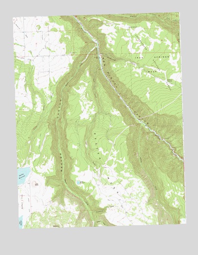
Gurley Canyon, CO USGS Topographic Map
Click on map above to begin viewing in our Map Viewer.

This topographic map contains these locations and features:
Feature Name Type Latitude Longitude GNIS ID View Map
Beaver CanyonValleyN38.1062°W108.1876°176411View Map
Beaver CreekStreamN38.1058°W108.1879°176413View Map
Beaver-Perkin PlacersMineN38.0030°W108.1773°1734207View Map
Comanche DrawValleyN38.0085°W108.1961°186217View Map
Cornforth DitchCanalN38.0819°W108.2190°186214View Map
Goodenough GulchValleyN38.1014°W108.1853°186220View Map
Granger Placer MineMineN38.1025°W108.1951°1745506View Map
Gurley CanyonValleyN38.0997°W108.2361°186221View Map
Gurley DamDamN38.0355°W108.2459°198468View Map
Gurley ReservoirReservoirN38.0301°W108.2499°203198View Map
Gutshall SpringSpringN38.1167°W108.1639°186223View Map
Huff GulchValleyN38.0946°W108.1857°186218View Map
Little BaldySummitN38.0261°W108.2376°186216View Map
McKeever ReservoirReservoirN38.0846°W108.1367°186215View Map
North CreekStreamN38.1203°W108.1379°186142View Map
Old Nelson DitchCanalN38.0025°W108.2409°202383View Map
Pekin Placer MineMineN38.0947°W108.1748°1745507View Map
Point ReservoirReservoirN38.0262°W108.2048°186222View Map
Saint Joe DrawValleyN38.1137°W108.1261°186224View Map
Saint Joe SpringSpringN38.0940°W108.1255°186228View Map
Saltado CreekStreamN38.0608°W108.1567°176393View Map
San Miguel RanchLocaleN38.0994°W108.1862°186219View Map
Sunup MineMineN38.0494°W108.1287°1735678View Map
Turner CreekStreamN38.0025°W108.1940°176392View Map
Wolf DitchCanalN38.0061°W108.1695°202385View Map

Note: Coordinates in the location and feature list above are referenced to NAD83 datum.


Copyright (C) 2008-2024 Ryan Niemi / Sunset Dynamics ... All Rights Reserved