TopoQuest Logo
Do you find TopoQuest useful?
Help keep TopoQuest running and adding new maps/features by donating!
Bitcoin:  19c7KJd3qBynnjoSw5npx9KScwjBe4ifkT
Litecoin:  LXs6TkuXGGXo1vDsWCkWVdjQX94eUKd6ui
Home View Maps Find Maps Find Places Resources & Links


Grover, Wyoming Topographic Map

USGS Map Title: Grover, WY
USGS Map MRC: 42110G8
DRG (GeoTIFF) Download: o42110g8.tif


Neighboring USGS Topographic Map Quads:


  Thayne West, WY  
42111H1
 

  Thayne East, WY  
42110H8
 

  Man Peak, WY  
42110H7
 

  Auburn, WY  
42111G1
 

  Grover, WY  
42110G8
 

  Rock Lake Peak, WY  
42110G7
 

  Sage Valley, ID  
42111F1
 

  Afton, WY  
42110F8
 

  Red Top Mountain, WY  
42110F7


Map MRC Location:

N43°
W111°
N43°
W110°
H8 H7 H6 H5 H4 H3 H2 H1
G8 G7 G6 G5 G4 G3 G2 G1
F8 F7 F6 F5 F4 F3 F2 F1
E8 E7 E6 E5 E4 E3 E2 E1
D8 D7 D6 D5 D4 D3 D2 D1
C8 C7 C6 C5 C4 C3 C2 C1
B8 B7 B6 B5 B4 B3 B2 B1
A8 A7 A6 A5 A4 A3 A2 A1
N42°
W111°
N42°
W110°

Grover, WY USGS 1:24K Topographic Map Preview:
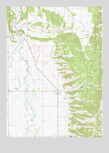
Grover, WY USGS Topographic Map
Click on map above to begin viewing in our Map Viewer.

This topographic map contains these locations and features:
Feature Name Type Latitude Longitude GNIS ID View Map
Anderson CanyonValleyN42.7555°W110.9230°1597746View Map
Astle CreekStreamN42.7969°W110.9360°1597826View Map
Bear Trap GulchValleyN42.8335°W110.9021°1598028View Map
Blaney CanyonValleyN42.7660°W110.9233°1598241View Map
Bradshaw CanyonValleyN42.8241°W110.9485°1598352View Map
Broad HollowValleyN42.8016°W110.8983°1598380View Map
Cemetery GulchValleyN42.7841°W110.9252°1598686View Map
Churchhouse HollowValleyN42.8066°W110.8941°1598755View Map
Crow CreekStreamN42.7533°W110.9742°380101View Map
Dry CanyonValleyN42.8608°W110.8930°1599323View Map
Dutson CanyonValleyN42.8021°W110.9355°1599430View Map
GroverPopulated PlaceN42.7916°W110.9366°1600129View Map
Grover CemeteryCemeteryN42.7871°W110.9225°1600130View Map
Grover Census Designated PlaceCensusN42.7947°W110.9295°2408340View Map
Grover CreekStreamN42.8180°W110.9749°1600131View Map
Grover ParkParkN42.8088°W110.8935°1600132View Map
Grover Post OfficePost OfficeN42.7913°W110.9331°2768521View Map
Heiner AirportAirportN42.8625°W110.8984°1608959View Map
Jensen CanyonValleyN42.7808°W110.9246°1600604View Map
Jensen CreekStreamN42.8388°W110.9844°1600606View Map
KRSV-FM (Afton)TowerN42.8505°W110.9802°1608821View Map
Leefe MineMineN42.8333°W110.8841°1726532View Map
Lily HollowValleyN42.7519°W110.9202°1600910View Map
North Fork Swift CreekStreamN42.7519°W110.8758°1601823View Map
Phillips CreekStreamN42.7891°W110.9277°1602120View Map
Spring CreekStreamN42.8260°W110.9947°1603263View Map
Spruce HollowValleyN42.7955°W110.9063°1603292View Map
Stump CreekStreamN42.8033°W110.9770°391564View Map
The NarrowsGapN42.8483°W110.9855°1603604View Map
Toms CreekStreamN42.8270°W110.9924°392231View Map
TurnervillePopulated PlaceN42.8588°W110.9019°1853215View Map
Turnerville CemeteryCemeteryN42.8482°W110.8879°2774430View Map
Turnerville Census Designated PlaceCensusN42.8623°W110.9007°2409365View Map
Turnerville CommunityLocaleN42.8483°W110.8960°1603801View Map
White Pine CreekStreamN42.8452°W110.9033°1604142View Map
Willow CreekStreamN42.8560°W110.9908°1604207View Map

Note: Coordinates in the location and feature list above are referenced to NAD83 datum.


Copyright (C) 2008-2024 Ryan Niemi / Sunset Dynamics ... All Rights Reserved