TopoQuest Logo
Do you find TopoQuest useful?
Help keep TopoQuest running and adding new maps/features by donating!
Bitcoin:  19c7KJd3qBynnjoSw5npx9KScwjBe4ifkT
Litecoin:  LXs6TkuXGGXo1vDsWCkWVdjQX94eUKd6ui
Home View Maps Find Maps Find Places Resources & Links


Grover, Utah Topographic Map

USGS Map Title: Grover, UT
USGS Map MRC: 38111B3
DRG (GeoTIFF) Download: o38111b3.tif


Neighboring USGS Topographic Map Quads:


  Torrey, UT  
38111C4
 

  Twin Rocks, UT  
38111C3
 

  Fruita, UT  
38111C2
 

  Blind Lake, UT  
38111B4
 

  Grover, UT  
38111B3
 

  Golden Throne, UT  
38111B2
 

  Deer Creek Lake, UT  
38111A4
 

  Lower Bowns Reservoir, UT  
38111A3
 

  Bear Canyon, UT  
38111A2


Map MRC Location:

N39°
W112°
N39°
W111°
H8 H7 H6 H5 H4 H3 H2 H1
G8 G7 G6 G5 G4 G3 G2 G1
F8 F7 F6 F5 F4 F3 F2 F1
E8 E7 E6 E5 E4 E3 E2 E1
D8 D7 D6 D5 D4 D3 D2 D1
C8 C7 C6 C5 C4 C3 C2 C1
B8 B7 B6 B5 B4 B3 B2 B1
A8 A7 A6 A5 A4 A3 A2 A1
N38°
W112°
N38°
W111°

Grover, UT USGS 1:24K Topographic Map Preview:
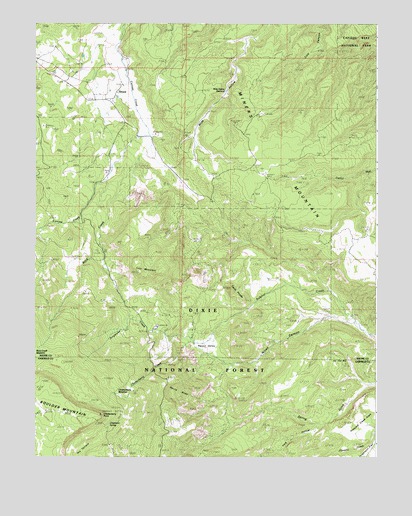
Grover, UT USGS Topographic Map
Click on map above to begin viewing in our Map Viewer.

This topographic map contains these locations and features:
Feature Name Type Latitude Longitude GNIS ID View Map
Chipmunk SpringSpringN38.1345°W111.3482°1435297View Map
Chokecherry CreekStreamN38.1578°W111.3202°1426606View Map
Chokecherry MeadowFlatN38.1441°W111.3427°1435299View Map
Chokecherry PointCapeN38.1372°W111.3507°1426612View Map
Devils SlideSlopeN38.1441°W111.3221°1435423View Map
GroverPopulated PlaceN38.2280°W111.3499°1437575View Map
Grover CemeteryCemeteryN38.2332°W111.3499°2769410View Map
Happy ValleyBasinN38.1569°W111.3141°1428520View Map
Larb HollowValleyN38.1342°W111.2705°1437879View Map
Lion MountainSummitN38.1784°W111.3373°1429655View Map
Miners MountainSummitN38.2124°W111.2848°1443516View Map
Nixon CanyonValleyN38.1652°W111.2689°1430727View Map
Pleasant Creek FlatsFlatN38.1353°W111.2549°1444477View Map
Rock CreekStreamN38.2211°W111.3355°1431911View Map
Rock Creek MeadowFlatN38.1553°W111.3730°1436247View Map
Singletree CampgroundLocaleN38.1628°W111.3304°1454895View Map
Singletree CreekStreamN38.1578°W111.3202°1432484View Map
The Three BrothersRangeN38.1572°W111.3021°1449989View Map
Twin PeaksSummitN38.1738°W111.3040°1433741View Map
Wide Hollow ReservoirReservoirN38.2306°W111.3057°1436641View Map

Note: Coordinates in the location and feature list above are referenced to NAD83 datum.


Copyright (C) 2008-2024 Ryan Niemi / Sunset Dynamics ... All Rights Reserved