TopoQuest Logo
Do you find TopoQuest useful?
Help keep TopoQuest running and adding new maps/features by donating!
Bitcoin:  19c7KJd3qBynnjoSw5npx9KScwjBe4ifkT
Litecoin:  LXs6TkuXGGXo1vDsWCkWVdjQX94eUKd6ui
Home View Maps Find Maps Find Places Resources & Links


Greenville, Georgia Topographic Map

USGS Map Title: Greenville, GA
USGS Map MRC: 33084A6
DRG (GeoTIFF) Download: o33084a6.tif


Neighboring USGS Topographic Map Quads:


  Grantville, GA  
33084B7
 

  Luthersville, GA  
33084B6
 

  Haralson, GA  
33084B5
 

  Odessadale, GA  
33084A7
 

  Greenville, GA  
33084A6
 

  Gay, GA  
33084A5
 

  Durand, GA  
32084H7
 

  Warm Springs, GA  
32084H6
 

  Woodbury, GA  
32084H5


Map MRC Location:

N34°
W85°
N34°
W84°
H8 H7 H6 H5 H4 H3 H2 H1
G8 G7 G6 G5 G4 G3 G2 G1
F8 F7 F6 F5 F4 F3 F2 F1
E8 E7 E6 E5 E4 E3 E2 E1
D8 D7 D6 D5 D4 D3 D2 D1
C8 C7 C6 C5 C4 C3 C2 C1
B8 B7 B6 B5 B4 B3 B2 B1
A8 A7 A6 A5 A4 A3 A2 A1
N33°
W85°
N33°
W84°

Greenville, GA USGS 1:24K Topographic Map Preview:
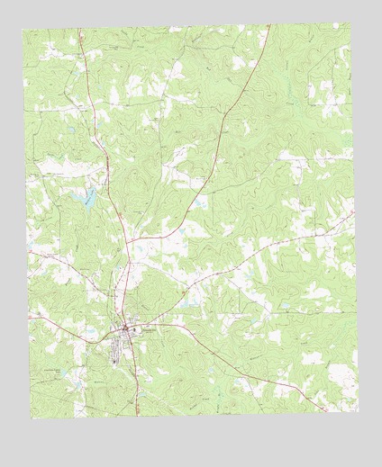
Greenville, GA USGS Topographic Map
Click on map above to begin viewing in our Map Viewer.

This topographic map contains these locations and features:
Feature Name Type Latitude Longitude GNIS ID View Map
AlliePopulated PlaceN33.0993°W84.7288°331027View Map
American Legion LakeLakeN33.0147°W84.7370°310509View Map
Blount CemeteryCemeteryN33.0473°W84.7296°311534View Map
Blount CreekStreamN33.0660°W84.7260°311535View Map
Blount Peavy CemeteryCemeteryN33.0523°W84.7413°354773View Map
Bowes ChapelChurchN33.0760°W84.6805°354825View Map
Brittens CreekStreamN33.1123°W84.6794°311810View Map
City of GreenvilleCivilN33.0322°W84.7162°2403751View Map
Fellowship CemeteryCemeteryN33.1185°W84.7130°314096View Map
Fellowship ChurchChurchN33.1162°W84.7274°355783View Map
Flatrock ChurchChurchN33.0951°W84.6985°355836View Map
GreenvillePopulated PlaceN33.0287°W84.7130°356105View Map
Greenville Church CemeteryCemeteryN33.0654°W84.7052°314872View Map
Greenville DivisionCivilN33.0351°W84.7365°1936298View Map
Greenville Elementary SchoolSchoolN33.0179°W84.7174°346867View Map
Greenville High SchoolSchoolN33.0481°W84.7092°346869View Map
Greenville Historic DistrictParkN33.0287°W84.7127°346870View Map
Greenville Middle SchoolSchoolN33.0282°W84.7095°2545557View Map
Greenville Police DepartmentBuildingN33.0292°W84.7135°2733778View Map
Greenville United Methodist ChurchChurchN33.0290°W84.7124°346872View Map
Kendal CreekStreamN33.0046°W84.6780°316373View Map
Kennel CreekStreamN33.0154°W84.6935°316386View Map
Mathis DamDamN33.0732°W84.7230°337535View Map
Mathis LakeReservoirN33.0704°W84.7264°317792View Map
Meriwether CountyCivilN33.0407°W84.6883°346892View Map
Meriwether County CourthouseBuildingN33.0287°W84.7130°346893View Map
Meriwether County JailBuildingN33.0443°W84.7113°346894View Map
Meriwether County Sheriff's OfficeBuildingN33.0445°W84.7113°2733483View Map
Meriwether County Volunteer Fire Department Station 1 HeadquartersBuildingN33.0291°W84.7353°2603540View Map
Mill CreekStreamN33.0954°W84.6458°318200View Map
Mount Pilgrim CemeteryCemeteryN33.0776°W84.7449°318802View Map
Mount Pilgrim ChurchChurchN33.0785°W84.7394°318808View Map
Parks CreekStreamN33.0815°W84.7097°320240View Map
Perkerson Veterans Club DamDamN33.0368°W84.6899°340202View Map
Perkerson Veterans Club LakeReservoirN33.0359°W84.6901°340203View Map
Rust Chapel Methodist ChurchChurchN33.0321°W84.7116°346915View Map
Sandy CreekStreamN33.1198°W84.6947°322468View Map
Sims BranchStreamN33.0282°W84.6294°323022View Map
Winslow CreekStreamN33.0629°W84.7499°325461View Map
Winslow CreekStreamN33.0718°W84.7327°325462View Map
WoodcraftPopulated PlaceN33.0801°W84.7185°346937View Map
Wright BranchStreamN33.0093°W84.6780°330386View Map

Note: Coordinates in the location and feature list above are referenced to NAD83 datum.


Copyright (C) 2008-2024 Ryan Niemi / Sunset Dynamics ... All Rights Reserved