TopoQuest Logo
Do you find TopoQuest useful?
Help keep TopoQuest running and adding new maps/features by donating!
Bitcoin:  19c7KJd3qBynnjoSw5npx9KScwjBe4ifkT
Litecoin:  LXs6TkuXGGXo1vDsWCkWVdjQX94eUKd6ui
Home View Maps Find Maps Find Places Resources & Links


Greenleafton, Minnesota Topographic Map

USGS Map Title: Greenleafton, MN
USGS Map MRC: 43092E2
DRG (GeoTIFF) Download: o43092e2.tif


Neighboring USGS Topographic Map Quads:


  Wykoff, MN  
43092F3
 

  Fountain, MN  
43092F2
 

  Preston, MN  
43092F1
 

  Cherry Grove, MN  
43092E3
 

  Greenleafton, MN  
43092E2
 

  Harmony, MN  
43092E1
 

  Lime Springs, IA  
43092D3
 

  Cresco NW, IA  
43092D2
 

  Cresco NE, IA  
43092D1


Map MRC Location:

N44°
W93°
N44°
W92°
H8 H7 H6 H5 H4 H3 H2 H1
G8 G7 G6 G5 G4 G3 G2 G1
F8 F7 F6 F5 F4 F3 F2 F1
E8 E7 E6 E5 E4 E3 E2 E1
D8 D7 D6 D5 D4 D3 D2 D1
C8 C7 C6 C5 C4 C3 C2 C1
B8 B7 B6 B5 B4 B3 B2 B1
A8 A7 A6 A5 A4 A3 A2 A1
N43°
W93°
N43°
W92°

Greenleafton, MN USGS 1:24K Topographic Map Preview:
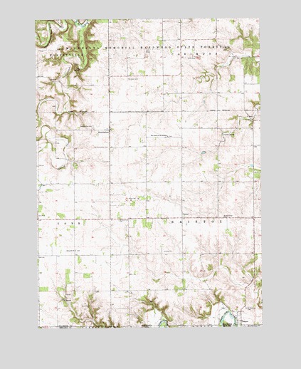
Greenleafton, MN USGS Topographic Map
Click on map above to begin viewing in our Map Viewer.

This topographic map contains these locations and features:
Feature Name Type Latitude Longitude GNIS ID View Map
BristolPopulated PlaceN43.5444°W92.1693°640488View Map
Bristol Center CemeteryCemeteryN43.5444°W92.1465°2050808View Map
Bristol Grove CemeteryCemeteryN43.5436°W92.2043°640489View Map
Bristol Post Office (historical)Post OfficeN43.5444°W92.1693°2050643View Map
Canfield CreekStreamN43.6222°W92.2241°640866View Map
Church of the BrethrenChurchN43.5772°W92.1771°653107View Map
Crystal SpringSpringN43.5780°W92.1460°642540View Map
East Willow Creek DamDamN43.6000°W92.1502°1776456View Map
East Willow Creek DamDamN43.6000°W92.1418°1776458View Map
East Willow Creek DamDamN43.5750°W92.1418°1776460View Map
GrangerPopulated PlaceN43.5022°W92.1388°644345View Map
Granger Post OfficePost OfficeN43.5022°W92.1388°2050626View Map
GreenleaftonPopulated PlaceN43.5802°W92.2093°644449View Map
Greenleafton CemeteryCemeteryN43.5819°W92.2182°644450View Map
Greenleafton Post Office (historical)Post OfficeN43.5802°W92.2093°2050625View Map
Greenleafton Reformed ChurchChurchN43.5805°W92.2085°2050860View Map
Hanning Brothers Group Pond DamDamN43.6233°W92.1635°1777239View Map
Old Greenleafton CemeteryCemeteryN43.5730°W92.2099°648925View Map
Saetersdal Norwegian Evangelical Lutheran CemeteryCemeteryN43.5313°W92.2282°2050807View Map
Saetersdale ChurchChurchN43.5314°W92.2288°650467View Map
Saint Liguori CemeteryCemeteryN43.6005°W92.1990°650795View Map
Saint Mathews CemeteryCemeteryN43.5075°W92.1340°650890View Map
Saint Matthew's Lutheran ChurchChurchN43.5025°W92.1366°2050829View Map
Township of BristolCivilN43.5440°W92.1494°663668View Map

Note: Coordinates in the location and feature list above are referenced to NAD83 datum.


Copyright (C) 2008-2024 Ryan Niemi / Sunset Dynamics ... All Rights Reserved