TopoQuest Logo
Do you find TopoQuest useful?
Help keep TopoQuest running and adding new maps/features by donating!
Bitcoin:  19c7KJd3qBynnjoSw5npx9KScwjBe4ifkT
Litecoin:  LXs6TkuXGGXo1vDsWCkWVdjQX94eUKd6ui
Home View Maps Find Maps Find Places Resources & Links


Green Creek, Montana Topographic Map

USGS Map Title: Green Creek, MT
USGS Map MRC: 45106D3
DRG (GeoTIFF) Download: o45106d3.tif


Neighboring USGS Topographic Map Quads:


  Hollowwood Creek, MT  
45106E4
 

  Ashland, MT  
45106E3
 

  Willow Crossing, MT  
45106E2
 

  Birney Day School, MT  
45106D4
 

  Green Creek, MT  
45106D3
 

  King Mountain, MT  
45106D2
 

  Browns Mountain, MT  
45106C4
 

  Poker Jim Butte, MT  
45106C3
 

  Fort Howes, MT  
45106C2


Map MRC Location:

N46°
W107°
N46°
W106°
H8 H7 H6 H5 H4 H3 H2 H1
G8 G7 G6 G5 G4 G3 G2 G1
F8 F7 F6 F5 F4 F3 F2 F1
E8 E7 E6 E5 E4 E3 E2 E1
D8 D7 D6 D5 D4 D3 D2 D1
C8 C7 C6 C5 C4 C3 C2 C1
B8 B7 B6 B5 B4 B3 B2 B1
A8 A7 A6 A5 A4 A3 A2 A1
N45°
W107°
N45°
W106°

Green Creek, MT USGS 1:24K Topographic Map Preview:
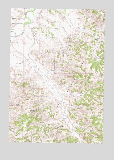
Green Creek, MT USGS Topographic Map
Click on map above to begin viewing in our Map Viewer.

This topographic map contains these locations and features:
Feature Name Type Latitude Longitude GNIS ID View Map
04S44E18____01 WellWellN45.4872°W106.3467°809739View Map
04S44E18ABDC01 WellWellN45.4931°W106.3436°809774View Map
04S44E19ACDC01 SpringSpringN45.4750°W106.3439°809677View Map
04S44E22ABDA01 WellWellN45.4722°W106.2806°809665View Map
04S44E23DCAA01 WellWellN45.4725°W106.2600°809666View Map
04S44E28BADA01 WellWellN45.4669°W106.3067°809640View Map
04S44E31BCAB01 WellWellN45.4500°W106.3550°809535View Map
04S44E32DCDD01 WellWellN45.4400°W106.3220°809499View Map
05S41E13CADA01 WellWellN45.4006°W106.3681°809312View Map
05S44E02AAAD01 SpringSpringN45.4387°W106.2548°809493View Map
05S44E05CAAD01 WellWellN45.4303°W106.3275°809444View Map
05S44E05CABD01 WellWellN45.4311°W106.3275°809446View Map
05S44E16ABBB01 WellWellN45.4103°W106.3053°809363View Map
05S44E27ADAB01 WellWellN45.3764°W106.2792°809179View Map
08S44E09DBDD01 WellWellN45.3994°W106.3311°809305View Map
Black CanyonValleyN45.4547°W106.2570°779986View Map
Cedar CreekStreamN45.4969°W106.3470°781089View Map
Dry CreekStreamN45.4864°W106.3484°782558View Map
Dry Creek WellWellN45.4667°W106.3070°782592View Map
East Fork O'Dell CreekStreamN45.4208°W106.3139°782883View Map
East Fork ReservoirReservoirN45.4066°W106.2671°782894View Map
Frees CreekStreamN45.4214°W106.3147°783718View Map
Gate Creek SpringSpringN45.4095°W106.3619°783861View Map
Good SpringSpringN45.4386°W106.2547°784092View Map
Gooseberry DrawValleyN45.3917°W106.2889°784117View Map
Green CreekStreamN45.4031°W106.3034°784272View Map
Green Creek ReservoirReservoirN45.3904°W106.3087°784275View Map
Green Creek SpringSpringN45.3926°W106.3236°784276View Map
Hay CreekStreamN45.3756°W106.2814°784646View Map
Hole-in-the-Wall CreekStreamN45.4372°W106.3300°784935View Map
Kelty CreekStreamN45.4739°W106.3689°785670View Map
King Creek ReservoirReservoirN45.4699°W106.2901°785743View Map
King Creek SpringSpringN45.4733°W106.2605°785744View Map
King Creek Well Number OneWellN45.4722°W106.2600°785745View Map
King Creek Well Number TwoWellN45.4817°W106.2806°785746View Map
King Mountain Hiking and Riding AreaParkN45.4292°W106.2756°794912View Map
O'Dell WindmillLocaleN45.4308°W106.3297°788367View Map
Pittman DrawValleyN45.4128°W106.3278°788964View Map
Pittman Draw SpringSpringN45.4046°W106.3413°788965View Map
Pittman ReservoirReservoirN45.4103°W106.2942°788966View Map
Poker Teechee ReservoirReservoirN45.3821°W106.3658°789045View Map
Schaudel ReservoirReservoirN45.4913°W106.2876°790114View Map
Section Sixteen WindmillLocaleN45.3978°W106.2995°790185View Map

Note: Coordinates in the location and feature list above are referenced to NAD83 datum.


Copyright (C) 2008-2024 Ryan Niemi / Sunset Dynamics ... All Rights Reserved