TopoQuest Logo
Do you find TopoQuest useful?
Help keep TopoQuest running and adding new maps/features by donating!
Bitcoin:  19c7KJd3qBynnjoSw5npx9KScwjBe4ifkT
Litecoin:  LXs6TkuXGGXo1vDsWCkWVdjQX94eUKd6ui
Home View Maps Find Maps Find Places Resources & Links


Green Cove Springs, Florida Topographic Map

USGS Map Title: Green Cove Springs, FL
USGS Map MRC: 29081H6
DRG (GeoTIFF) Download: o29081h6.tif


Neighboring USGS Topographic Map Quads:


  Middleburg, FL  
30081A7
 

  Fleming Island, FL  
30081A6
 

  Orangedale, FL  
30081A5
 

  Penney Farms, FL  
29081H7
 

  Green Cove Springs, FL  
29081H6
 

  Picolata, FL  
29081H5
 

  Rice Creek, FL  
29081G7
 

  Bostwick, FL  
29081G6
 

  Riverdale, FL  
29081G5


Map MRC Location:

N30°
W82°
N30°
W81°
H8 H7 H6 H5 H4 H3 H2 H1
G8 G7 G6 G5 G4 G3 G2 G1
F8 F7 F6 F5 F4 F3 F2 F1
E8 E7 E6 E5 E4 E3 E2 E1
D8 D7 D6 D5 D4 D3 D2 D1
C8 C7 C6 C5 C4 C3 C2 C1
B8 B7 B6 B5 B4 B3 B2 B1
A8 A7 A6 A5 A4 A3 A2 A1
N29°
W82°
N29°
W81°

Green Cove Springs, FL USGS 1:24K Topographic Map Preview:
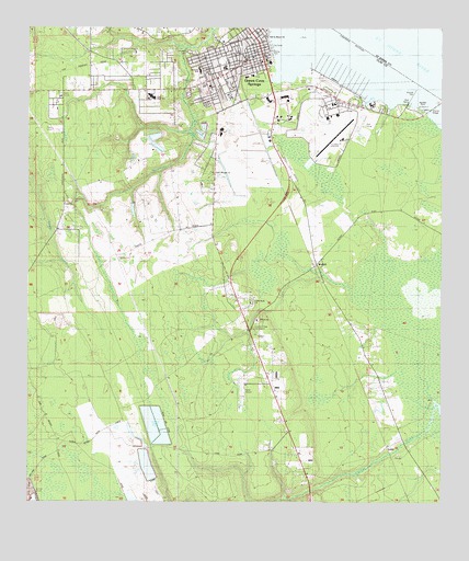
Green Cove Springs, FL USGS Topographic Map
Click on map above to begin viewing in our Map Viewer.

This topographic map contains these locations and features:
Feature Name Type Latitude Longitude GNIS ID View Map
Charles E Bennett Elementary SchoolSchoolN29.9889°W81.6979°297426View Map
Christian Fellowship ChurchChurchN29.9830°W81.6926°294988View Map
Church of God in ChristChurchN29.9911°W81.6851°294998View Map
City of Green Cove SpringsCivilN29.9903°W81.6808°2403735View Map
Clay County Center for Community EducationSchoolN29.9900°W81.6906°297427View Map
Clay County Fire Rescue Green Cove Springs Station 20BuildingN29.9854°W81.6962°2644127View Map
Clay County Fire Rescue Virginia Village Station 24BuildingN29.9213°W81.6814°304855View Map
Clay County Historical SocietyBuildingN29.9918°W81.6839°2449248View Map
Clay County Historical Society LibraryBuildingN29.9924°W81.6841°2449249View Map
Clay County Public LibraryBuildingN29.9877°W81.6818°298059View Map
Clay County Public Library System Green Cove Springs Branch LibraryBuildingN29.9914°W81.6794°2449250View Map
Clay High SchoolSchoolN29.9824°W81.7131°297425View Map
Clay High SchoolSchoolN29.9822°W81.7130°304852View Map
Community ChapelChurchN29.9891°W81.6879°294990View Map
Congregational Holiness ChurchChurchN29.9830°W81.7162°304851View Map
Cove PlazaLocaleN29.9914°W81.6784°295917View Map
Cove Plaza Shopping CenterLocaleN29.9812°W81.6773°2476719View Map
Faith Baptist TempleChurchN29.9619°W81.6943°304860View Map
First African ChurchChurchN29.9972°W81.6826°294996View Map
First Baptist ChurchChurchN29.9925°W81.6820°294994View Map
First Presbyterian ChurchChurchN29.9966°W81.6798°294992View Map
First United Methodist Church of Green Cove SpringsChurchN29.9930°W81.6809°294993View Map
Fort Pupo (historical)MilitaryN29.9667°W81.6667°307410View Map
Grace Baptist ChurchChurchN29.9547°W81.7370°304858View Map
Greater Mount Pleasant Baptist ChurchChurchN29.9947°W81.6945°294984View Map
Green Cove PlazaLocaleN29.9894°W81.6815°295916View Map
Green Cove SpringsPopulated PlaceN29.9919°W81.6781°283381View Map
Green Cove Springs Assembly of God ChurchChurchN29.9814°W81.6940°294987View Map
Green Cove Springs DivisionCivilN29.9247°W81.6941°1935782View Map
Green Cove Springs Elementary SchoolSchoolN29.9919°W81.6837°297428View Map
Green Cove Springs MarinaHarborN29.9888°W81.6629°2449252View Map
Green Cove Springs Police DepartmentBuildingN29.9894°W81.6860°2333140View Map
Green Cove Springs Post OfficePost OfficeN29.9941°W81.6811°2476290View Map
Haller AirparkAirportN29.9028°W81.6852°309464View Map
Hickory Grove Baptist ChurchChurchN29.9847°W81.6951°308447View Map
Hickory Grove CemeteryCemeteryN29.9680°W81.6951°304850View Map
Holly Hill Memorial Park and MausoleumCemeteryN29.9836°W81.7012°298060View Map
House of Worship ChurchChurchN29.9855°W81.6920°294989View Map
Idlewild Trailer ParkPopulated PlaceN29.9886°W81.6880°2449245View Map
Jacksonville Memory GardensCemeteryN29.9961°W81.6790°298063View Map
Johns Mobile Home ParkPopulated PlaceN29.9823°W81.6965°2449246View Map
Kindred Hospital North FloridaHospitalN29.9878°W81.6820°298095View Map
LenoPopulated PlaceN29.8897°W81.6406°295404View Map
Little Ruth CemeteryCemeteryN29.9280°W81.6818°304854View Map
Little Ruth ChurchChurchN29.9264°W81.6820°301089View Map
Little Ruth ChurchChurchN29.9277°W81.6818°304853View Map
Mount Olive CemeteryCemeteryN29.9941°W81.7004°308450View Map
Mount Zion ChurchChurchN29.9994°W81.6851°294991View Map
Naval Auxiliary Air Station Green Cove Springs (historical)MilitaryN29.9739°W81.6600°2100577View Map
Old Saint Marys ChurchChurchN29.9969°W81.6768°288115View Map
R C Bannerman Learning CenterSchoolN29.9966°W81.6911°297429View Map
Red BayBayN29.9813°W81.6472°289530View Map
Red Bay CreekStreamN29.9800°W81.6479°305023View Map
Red Bay PointCapeN29.9783°W81.6284°289534View Map
Reynolds AirparkAirportN29.9710°W81.6559°309463View Map
Reynolds Industrial ParkLocaleN29.9769°W81.6581°304859View Map
Rio Vista Trailer ParkPopulated PlaceN29.9864°W81.6655°2449254View Map
Sacred Heart Catholic ChurchChurchN29.9911°W81.6801°294986View Map
Shiloh ChurchChurchN29.9233°W81.6801°291036View Map
Spring ParkParkN29.9933°W81.6770°294995View Map
Springbank CemeteryCemeteryN29.9547°W81.7370°304857View Map
Sunshine Holiness ChurchChurchN29.9944°W81.6926°294985View Map
Tot Lot ParkParkN29.9994°W81.6859°294997View Map
Triumph ChurchChurchN29.9961°W81.6931°294983View Map
WalkillPopulated PlaceN29.9380°W81.6620°295696View Map

Note: Coordinates in the location and feature list above are referenced to NAD83 datum.


Copyright (C) 2008-2024 Ryan Niemi / Sunset Dynamics ... All Rights Reserved