TopoQuest Logo
Do you find TopoQuest useful?
Help keep TopoQuest running and adding new maps/features by donating!
Bitcoin:  19c7KJd3qBynnjoSw5npx9KScwjBe4ifkT
Litecoin:  LXs6TkuXGGXo1vDsWCkWVdjQX94eUKd6ui
Home View Maps Find Maps Find Places Resources & Links


Addison, New York Topographic Map

USGS Map Title: Addison, NY
USGS Map MRC: 42077A2
DRG (GeoTIFF) Download: o42077a2.tif


Neighboring USGS Topographic Map Quads:


  Rathbone, NY  
42077B3
 

  Campbell, NY  
42077B2
 

  Corning, NY  
42077B1
 

  Borden, NY  
42077A3
 

  Addison, NY  
42077A2
 

  Caton, NY  
42077A1
 

  Elkland, PA  
41077H3
 

  Tioga, PA  
41077H2
 

  Jackson Summit, PA  
41077H1


Map MRC Location:

N43°
W78°
N43°
W77°
H8 H7 H6 H5 H4 H3 H2 H1
G8 G7 G6 G5 G4 G3 G2 G1
F8 F7 F6 F5 F4 F3 F2 F1
E8 E7 E6 E5 E4 E3 E2 E1
D8 D7 D6 D5 D4 D3 D2 D1
C8 C7 C6 C5 C4 C3 C2 C1
B8 B7 B6 B5 B4 B3 B2 B1
A8 A7 A6 A5 A4 A3 A2 A1
N42°
W78°
N42°
W77°

Addison, NY USGS 1:24K Topographic Map Preview:
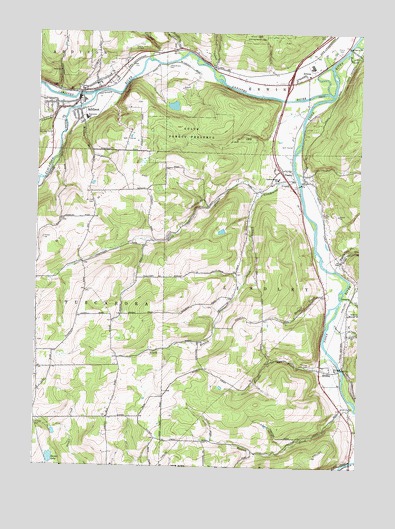
Addison, NY USGS Topographic Map
Click on map above to begin viewing in our Map Viewer.

This topographic map contains these locations and features:
Feature Name Type Latitude Longitude GNIS ID View Map
AddisonPopulated PlaceN42.1029°W77.2336°942177View Map
Addison Fire Station Number 2BuildingN42.1097°W77.2250°2370262View Map
Addison High SchoolSchoolN42.1053°W77.2319°2370253View Map
Addison Post OfficePost OfficeN42.1140°W77.2183°2599081View Map
Addison Public LibraryBuildingN42.1046°W77.2339°2599139View Map
Addison Town HallBuildingN42.1047°W77.2344°2370254View Map
Addison Village Wastewater Treatment PlantLocaleN42.1089°W77.2216°2597195View Map
Addison Volunteer Ambulance CorpsBuildingN42.1048°W77.2352°2719193View Map
Addison Volunteer Fire DepartmentBuildingN42.1048°W77.2351°2370255View Map
Baxter LakeReservoirN42.0022°W77.2435°943177View Map
Beeman HollowValleyN42.1206°W77.1964°943557View Map
Canisteo RiverStreamN42.1079°W77.1355°969956View Map
Canisteo River BridgeBridgeN42.1066°W77.1455°2599127View Map
Church CreekStreamN42.0431°W77.1341°946677View Map
Church of the RedeemerChurchN42.1083°W77.2325°2370259View Map
Cole CreekStreamN42.1142°W77.1816°947101View Map
Cowanesque River BridgeBridgeN42.0017°W77.1271°2599129View Map
Curtis SquareParkN42.1106°W77.2272°2370252View Map
Eagle HouseBuildingN42.1078°W77.2342°2370256View Map
ErwinsPopulated PlaceN42.1126°W77.1455°949703View Map
Erwins CemeteryCemeteryN42.1198°W77.1333°949704View Map
Fairview CemeteryCemeteryN42.0298°W77.1433°949829View Map
First Baptist ChurchChurchN42.1039°W77.2426°2598017View Map
First Methodist ChurchChurchN42.1078°W77.2325°2370260View Map
First Presbyterian ChurchChurchN42.1086°W77.2314°2370258View Map
Freeman CemeteryCemeteryN42.0358°W77.2487°2547968View Map
Glendening CreekStreamN42.0834°W77.1494°951207View Map
Goodhue CreekStreamN42.1176°W77.2058°951325View Map
Harrison School (historical)SchoolN42.0283°W77.1847°2375625View Map
Jesus Church Mennonite FellowshipChurchN42.0888°W77.2454°2597937View Map
Jones - Erwin CemeteryCemeteryN42.1155°W77.2004°954194View Map
Liberty Pole CemeteryCemeteryN42.0145°W77.2215°2547969View Map
Liberty Pole School (historical)SchoolN42.0142°W77.2217°2375627View Map
LindleyPopulated PlaceN42.0284°W77.1397°955407View Map
Lindley - Presho Elementary SchoolSchoolN42.0831°W77.1566°955409View Map
Lindley Community ChurchChurchN42.0284°W77.1389°2597943View Map
Lindley Post OfficePost OfficeN42.0274°W77.1397°2599095View Map
Lindley Presho Volunteer Fire DepartmentBuildingN42.0448°W77.1284°2735291View Map
Lumber City School (historical)SchoolN42.0614°W77.1300°2375628View Map
Morgan CreekStreamN42.0329°W77.1358°957660View Map
Mulholland CreekStreamN42.1206°W77.1294°958134View Map
Nichols CemeteryCemeteryN42.0120°W77.2500°958561View Map
North Branch Glendening CreekStreamN42.0792°W77.1625°958702View Map
Orr HillSummitN42.0659°W77.2472°959492View Map
Orr Hill School (historical)SchoolN42.0792°W77.2122°2375632View Map
Pinnacle State Park Golf CourseLocaleN42.0940°W77.2134°2599137View Map
PreshoPopulated PlaceN42.0856°W77.1547°961120View Map
Presho United Methodist ChurchChurchN42.0834°W77.1510°2597949View Map
Reuben BrookStreamN42.1073°W77.2180°962416View Map
Ryers CreekStreamN42.0573°W77.1344°963146View Map
Saint Catherine's Roman Catholic ChurchChurchN42.1103°W77.2260°2370261View Map
Scudder PitMineN42.1083°W77.1942°2709830View Map
South Branch Glendening CreekStreamN42.0792°W77.1628°965695View Map
Sovereign Grace Baptist ChurchChurchN42.1081°W77.2333°2597964View Map
Stead School (historical)SchoolN42.0436°W77.2172°2375635View Map
Stowell CreekStreamN42.0517°W77.1316°966610View Map
Stowell School (historical)SchoolN42.0436°W77.1492°2375637View Map
Sunflower Acres Mobile Home ParkPopulated PlaceN42.0645°W77.2108°2599115View Map
Tannery CreekStreamN42.0487°W77.1308°967053View Map
Tioga River BridgeBridgeN42.0288°W77.1317°2599133View Map
Town of LindleyCivilN42.0452°W77.1418°979153View Map
Towner Farm AirportAirportN42.1218°W77.2113°977877View Map
Tuscarora Baptist ChurchChurchN42.0218°W77.2485°2597969View Map
Tuscarora CreekStreamN42.1076°W77.2275°967994View Map
Tuscarora Elementary SchoolSchoolN42.1004°W77.2313°967999View Map
Village of AddisonCivilN42.1063°W77.2320°2391500View Map
Watson CreekStreamN42.0170°W77.1264°968925View Map
Wombaugh SquareParkN42.1089°W77.2322°2370257View Map

Note: Coordinates in the location and feature list above are referenced to NAD83 datum.


Copyright (C) 2008-2024 Ryan Niemi / Sunset Dynamics ... All Rights Reserved