TopoQuest Logo
Do you find TopoQuest useful?
Help keep TopoQuest running and adding new maps/features by donating!
Bitcoin:  19c7KJd3qBynnjoSw5npx9KScwjBe4ifkT
Litecoin:  LXs6TkuXGGXo1vDsWCkWVdjQX94eUKd6ui
Home View Maps Find Maps Find Places Resources & Links


Granby, Missouri Topographic Map

USGS Map Title: Granby, MO
USGS Map MRC: 36094H3
DRG (GeoTIFF) Download: o36094h3.tif


Neighboring USGS Topographic Map Quads:


  Joplin East, MO  
37094A4
 

  Fidelity, MO  
37094A3
 

  Reeds, MO  
37094A2
 

  Tipton Ford, MO  
36094H4
 

  Granby, MO  
36094H3
 

  Newtonia, MO  
36094H2
 

  Neosho West, MO  
36094G4
 

  Neosho East, MO  
36094G3
 

  Stella, MO  
36094G2


Map MRC Location:

N37°
W95°
N37°
W94°
H8 H7 H6 H5 H4 H3 H2 H1
G8 G7 G6 G5 G4 G3 G2 G1
F8 F7 F6 F5 F4 F3 F2 F1
E8 E7 E6 E5 E4 E3 E2 E1
D8 D7 D6 D5 D4 D3 D2 D1
C8 C7 C6 C5 C4 C3 C2 C1
B8 B7 B6 B5 B4 B3 B2 B1
A8 A7 A6 A5 A4 A3 A2 A1
N36°
W95°
N36°
W94°

Granby, MO USGS 1:24K Topographic Map Preview:
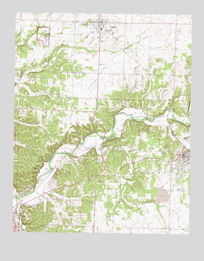
Granby, MO USGS Topographic Map
Click on map above to begin viewing in our Map Viewer.

This topographic map contains these locations and features:
Feature Name Type Latitude Longitude GNIS ID View Map
Birthplace SiteLocaleN36.9867°W94.3555°736203View Map
Boyd CemeteryCemeteryN36.9692°W94.3522°714594View Map
Carver BustParkN36.9867°W94.3527°736205View Map
Carver CemeteryCemeteryN36.9851°W94.3572°715461View Map
City of GranbyCivilN36.9180°W94.2607°2394948View Map
Croutchs Spur (historical)LocaleN36.9681°W94.2819°740393View Map
DiamondPopulated PlaceN36.9953°W94.3161°716874View Map
Diamond Area Fire Protection District Station 1BuildingN36.9953°W94.3126°2621416View Map
Diamond Area Fire Protection District Station 2BuildingN36.9444°W94.3207°2621276View Map
Diamond CemeteryCemeteryN36.9842°W94.3135°716875View Map
Diamond Elementary SchoolSchoolN36.9912°W94.3144°746315View Map
Diamond Grove PrairieAreaN36.9759°W94.3041°729870View Map
Diamond High SchoolSchoolN36.9891°W94.3138°2709532View Map
Diamond Middle SchoolSchoolN36.9901°W94.3145°2709531View Map
Diamond Police DepartmentBuildingN36.9951°W94.3129°2752260View Map
Diamond Post OfficePost OfficeN36.9952°W94.3146°2782646View Map
Dry BranchStreamN36.9259°W94.3277°717074View Map
East Newton Fire Protection DistrictBuildingN36.9203°W94.2556°2621650View Map
Eighteen Eighty-One Moses Carver HouseBuildingN36.9890°W94.3563°736204View Map
Field Early Childhood and Kindergarten CenterSchoolN36.8784°W94.3736°717900View Map
George Washington Carver National MonumentParkN36.9871°W94.3552°718402View Map
Gibson CemeteryCemeteryN36.8937°W94.3544°718427View Map
GranbyPopulated PlaceN36.9192°W94.2552°718664View Map
Granby CityPopulated PlaceN36.9417°W94.2697°740060View Map
Granby Elementary and Junior High SchoolSchoolN36.9173°W94.2515°745828View Map
Granby Fire DepartmentBuildingN36.9202°W94.2556°2621144View Map
Granby Memorial CemeteryCemeteryN36.9006°W94.2599°718665View Map
Granby Police DepartmentBuildingN36.9202°W94.2562°2752382View Map
Granby Post OfficePost OfficeN36.9187°W94.2555°2782676View Map
Greenwood CemeteryCemeteryN36.9737°W94.2752°718835View Map
Greenwood School (historical)SchoolN36.9662°W94.2805°2709550View Map
Hazelwood CemeteryCemeteryN36.8931°W94.3180°719305View Map
Hickory CreekStreamN36.8937°W94.3708°719443View Map
Kiddo School (historical)SchoolN36.9023°W94.3497°746337View Map
Kiddo Spur (historical)LocaleN36.9049°W94.3544°740392View Map
Lynch FieldAirportN36.9072°W94.3095°2679338View Map
Neosho Station (historical)LocaleN36.8909°W94.3724°740608View Map
Newton CountyCivilN36.9055°W94.3392°758527View Map
Shepherd Airport (historical)AirportN36.9884°W94.3197°758657View Map
Silver Moon ChurchChurchN36.9478°W94.3161°726456View Map
Silver Moon School (historical)SchoolN36.9442°W94.3341°746336View Map
Spencer BranchStreamN36.9428°W94.2516°726846View Map
Town of DiamondCivilN36.9970°W94.3152°2396686View Map
Township of GranbyCivilN36.9000°W94.2633°767076View Map
Williams BranchStreamN36.9884°W94.3586°736208View Map
Williams PondLakeN36.9889°W94.3551°736206View Map
Williams SpringSpringN36.9895°W94.3547°736207View Map

Note: Coordinates in the location and feature list above are referenced to NAD83 datum.


Copyright (C) 2008-2024 Ryan Niemi / Sunset Dynamics ... All Rights Reserved