TopoQuest Logo
Do you find TopoQuest useful?
Help keep TopoQuest running and adding new maps/features by donating!
Bitcoin:  19c7KJd3qBynnjoSw5npx9KScwjBe4ifkT
Litecoin:  LXs6TkuXGGXo1vDsWCkWVdjQX94eUKd6ui
Home View Maps Find Maps Find Places Resources & Links


Gnadenhutten, Ohio Topographic Map

USGS Map Title: Gnadenhutten, OH
USGS Map MRC: 40081C4
DRG (GeoTIFF) Download: o40081c4.tif


Neighboring USGS Topographic Map Quads:


  Stone Creek, OH  
40081D5
 

  New Philadelphia, OH  
40081D4
 

  Uhrichsville, OH  
40081D3
 

  Newcomerstown, OH  
40081C5
 

  Gnadenhutten, OH  
40081C4
 

  Tippecanoe, OH  
40081C3
 

  Kimbolton, OH  
40081B5
 

  Birmingham, OH  
40081B4
 

  Freeport, OH  
40081B3


Map MRC Location:

N41°
W82°
N41°
W81°
H8 H7 H6 H5 H4 H3 H2 H1
G8 G7 G6 G5 G4 G3 G2 G1
F8 F7 F6 F5 F4 F3 F2 F1
E8 E7 E6 E5 E4 E3 E2 E1
D8 D7 D6 D5 D4 D3 D2 D1
C8 C7 C6 C5 C4 C3 C2 C1
B8 B7 B6 B5 B4 B3 B2 B1
A8 A7 A6 A5 A4 A3 A2 A1
N40°
W82°
N40°
W81°

Gnadenhutten, OH USGS 1:24K Topographic Map Preview:
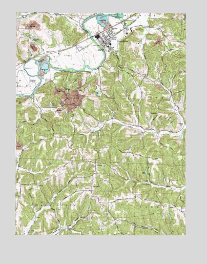
Gnadenhutten, OH USGS Topographic Map
Click on map above to begin viewing in our Map Viewer.

This topographic map contains these locations and features:
Feature Name Type Latitude Longitude GNIS ID View Map
Brown CemeteryCemeteryN40.3366°W81.4748°1038369View Map
Camp ZimmermanLocaleN40.3317°W81.4646°1038774View Map
Campground School (historical)SchoolN40.2728°W81.4118°1054388View Map
Canaan Hill ChurchChurchN40.2731°W81.4109°1038789View Map
Cappel School (historical)SchoolN40.2984°W81.4587°1054396View Map
Church of ChristChurchN40.3620°W81.4323°1964086View Map
Community ChurchChurchN40.3395°W81.4054°1080377View Map
Crossroads CemeteryCemeteryN40.3673°W81.4025°1039496View Map
Dutch Hollow School (historical)SchoolN40.3203°W81.4815°1054392View Map
Elm (historical)Populated PlaceN40.3120°W81.4101°1054387View Map
Fillmans Farms FieldAirportN40.3335°W81.4920°1082973View Map
Fox ValleyValleyN40.3723°W81.4534°1040640View Map
Frys CreekStreamN40.3659°W81.4493°1066721View Map
Frys ValleyValleyN40.3667°W81.4521°1060560View Map
Frys Valley CemeteryCemeteryN40.3737°W81.4712°1963827View Map
Frys Valley ChurchChurchN40.3737°W81.4704°1040714View Map
Frys Valley School (historical)SchoolN40.3742°W81.4701°1054391View Map
Full Gospel Pentecostal ChurchChurchN40.3678°W81.4198°1080379View Map
GilmorePopulated PlaceN40.2909°W81.4404°1048784View Map
Gilmore Post Office (historical)Post OfficeN40.2903°W81.4401°2062077View Map
GnadenhuttenPopulated PlaceN40.3584°W81.4343°1064736View Map
Gnadenhutten AirportAirportN40.3625°W81.4212°2442520View Map
Gnadenhutten CemeteryCemeteryN40.3548°W81.4337°1963828View Map
Gnadenhutten Fire DepartmentBuildingN40.3582°W81.4343°2549563View Map
Gnadenhutten Historical ParkParkN40.3545°W81.4337°1082154View Map
Gnadenhutten Moravian ChurchChurchN40.3578°W81.4343°1964087View Map
Gnadenhutten Police DepartmentBuildingN40.3582°W81.4342°2733079View Map
Gnadenhutten Post OfficePost OfficeN40.3589°W81.4369°1082310View Map
Gnadenhutten United Methodist ChurchChurchN40.3603°W81.4376°1964088View Map
HartwoodPopulated PlaceN40.2787°W81.4840°1062484View Map
Hartwood CemeteryCemeteryN40.2712°W81.4965°1963832View Map
Hartwood ChurchChurchN40.2715°W81.4968°1041382View Map
Hartwood Post Office (historical)Post OfficeN40.2792°W81.4846°2062078View Map
Hecks Grove ParkParkN40.3656°W81.4307°1080380View Map
Indian Valley High SchoolSchoolN40.3562°W81.4323°1054390View Map
Johnson RunStreamN40.3740°W81.4387°1066778View Map
Kennedy CemeteryCemeteryN40.3189°W81.3959°1080376View Map
Kennedy Church (historical)ChurchN40.3190°W81.3951°1080433View Map
Lake GreenbriarReservoirN40.3229°W81.4742°1078266View Map
Lake Greenbriar DamDamN40.3217°W81.4748°1078265View Map
Lake PageLakeN40.2854°W81.4041°1080375View Map
Lanning School (historical)SchoolN40.2645°W81.3829°1054389View Map
Lock SeventeenPopulated PlaceN40.3562°W81.4557°1082187View Map
Lock Seventeen CemeteryCemeteryN40.3510°W81.4595°1082188View Map
Murphy HollowValleyN40.2628°W81.4846°1043740View Map
North Springfield Post Office (historical)Post OfficeN40.3737°W81.4346°2056327View Map
Perry Township CemeteryCemeteryN40.2815°W81.3854°1963843View Map
Perry Township HallBuildingN40.2662°W81.3837°1080378View Map
River Hill CemeteryCemeteryN40.3073°W81.4726°1045040View Map
River Hill CemeteryCemeteryN40.3310°W81.4371°1045041View Map
Ross School (historical)SchoolN40.3215°W81.4498°1054393View Map
Rush SchoolSchoolN40.3128°W81.3771°1045280View Map
Rush Township Fire Department Station 7BuildingN40.3128°W81.3751°2549823View Map
Sanders School (historical)SchoolN40.3395°W81.4054°1054386View Map
School Number 3 (historical)SchoolN40.2740°W81.4965°1054397View Map
School Number 4 (historical)SchoolN40.2826°W81.4546°1054394View Map
School Number 5 (historical)SchoolN40.2537°W81.4604°1054395View Map
Schweitzer CemeteryCemeteryN40.3743°W81.4702°1963861View Map
Stocker Sand and Gravel PitMineN40.3708°W81.4400°2633438View Map
Township of ClayCivilN40.3446°W81.4646°1087052View Map
Township of PerryCivilN40.2525°W81.3843°1087062View Map
Township of WashingtonCivilN40.2550°W81.4789°1087070View Map
Village of GnadenhuttenCivilN40.3595°W81.4293°2398983View Map
Watson Creek School (historical)SchoolN40.3065°W81.4062°1077615View Map
West Union CemeteryCemeteryN40.2770°W81.4434°1963873View Map
West Union ChurchChurchN40.2776°W81.4429°1047808View Map
Yankeetown (historical)Populated PlaceN40.3584°W81.4437°1067252View Map

Note: Coordinates in the location and feature list above are referenced to NAD83 datum.


Copyright (C) 2008-2024 Ryan Niemi / Sunset Dynamics ... All Rights Reserved