TopoQuest Logo
Do you find TopoQuest useful?
Help keep TopoQuest running and adding new maps/features by donating!
Bitcoin:  19c7KJd3qBynnjoSw5npx9KScwjBe4ifkT
Litecoin:  LXs6TkuXGGXo1vDsWCkWVdjQX94eUKd6ui
Home View Maps Find Maps Find Places Resources & Links


Glen Allen, Alabama Topographic Map

USGS Map Title: Glen Allen, AL
USGS Map MRC: 33087H6
DRG (GeoTIFF) Download: o33087h6.tif


Neighboring USGS Topographic Map Quads:


  Brilliant, AL  
34087A7
 

  Gold Mine, AL  
34087A6
 

  Lynn, AL  
34087A5
 

  Winfield, AL  
33087H7
 

  Glen Allen, AL  
33087H6
 

  Carbon Hill, AL  
33087H5
 

  Winfield SE, AL  
33087G7
 

  Hubbertville, AL  
33087G6
 

  Howard, AL  
33087G5


Map MRC Location:

N34°
W88°
N34°
W87°
H8 H7 H6 H5 H4 H3 H2 H1
G8 G7 G6 G5 G4 G3 G2 G1
F8 F7 F6 F5 F4 F3 F2 F1
E8 E7 E6 E5 E4 E3 E2 E1
D8 D7 D6 D5 D4 D3 D2 D1
C8 C7 C6 C5 C4 C3 C2 C1
B8 B7 B6 B5 B4 B3 B2 B1
A8 A7 A6 A5 A4 A3 A2 A1
N33°
W88°
N33°
W87°

Glen Allen, AL USGS 1:24K Topographic Map Preview:
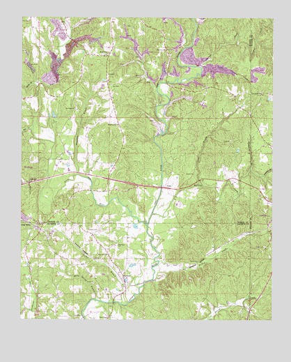
Glen Allen, AL USGS Topographic Map
Click on map above to begin viewing in our Map Viewer.

This topographic map contains these locations and features:
Feature Name Type Latitude Longitude GNIS ID View Map
BazemorePopulated PlaceN33.8945°W87.7000°113618View Map
Beasley CemeteryCemeteryN33.9776°W87.6706°113697View Map
Box CemeteryCemeteryN33.8807°W87.7056°158520View Map
Brown CemeteryCemeteryN33.8993°W87.6620°158794View Map
Central ChurchChurchN33.9768°W87.7075°115888View Map
Clifty CreekStreamN33.9740°W87.7436°116271View Map
Dutton CemeteryCemeteryN33.9354°W87.6642°117701View Map
Fern Springs ChurchChurchN33.9690°W87.6306°118259View Map
Freeman BranchStreamN33.9348°W87.6286°118622View Map
Glen AllenPopulated PlaceN33.9151°W87.7417°155077View Map
Glen Allen CemeteryCemeteryN33.9145°W87.7411°158517View Map
Glen Allen Post OfficePost OfficeN33.9147°W87.7400°168950View Map
Glen Allen Volunteer Fire DepartmentBuildingN33.9148°W87.7401°2683016View Map
Gooden CreekStreamN33.9979°W87.6264°159681View Map
Goodwin CreekStreamN33.9795°W87.6609°159684View Map
Gulf BranchStreamN33.9301°W87.6595°119460View Map
Hallmark CemeteryCemeteryN33.9870°W87.6789°119588View Map
Holcomb CemeteryCemeteryN33.9854°W87.6770°137993View Map
Hopewell CemeteryCemeteryN33.9120°W87.7120°120361View Map
Hopewell Church (historical)ChurchN33.9126°W87.7111°137738View Map
Humphrey BranchStreamN33.9379°W87.6359°120544View Map
Liberty CemeteryCemeteryN33.9625°W87.7226°154422View Map
Little Goodwin CreekStreamN33.9812°W87.6595°121794View Map
Little New RiverStreamN33.9145°W87.6870°121831View Map
Mallards CreekStreamN33.9184°W87.6850°152209View Map
Mill CreekStreamN33.9534°W87.7445°122797View Map
Mills Spring BranchStreamN33.8832°W87.7125°122850View Map
New Poplar ChurchChurchN33.9623°W87.7236°152666View Map
New RiverStreamN33.9143°W87.6872°160248View Map
O'Mary CemeteryCemeteryN33.9862°W87.6678°124048View Map
Piney Grove CemeteryCemeteryN33.9020°W87.7061°158518View Map
Piney Grove ChurchChurchN33.9020°W87.7070°124878View Map
Piney Grove Junior High SchoolSchoolN33.9057°W87.7020°165508View Map
Pleasant Grove CemeteryCemeteryN33.9562°W87.7039°138047View Map
Pleasant Grove ChurchChurchN33.9562°W87.7034°154487View Map
Poplar Springs CemeteryCemeteryN33.9626°W87.7225°138053View Map
Poplar Springs SchoolSchoolN33.9618°W87.7225°138054View Map
Rock CityPopulated PlaceN33.9845°W87.7086°153174View Map
Rock City ChurchChurchN33.9832°W87.7084°154421View Map
Rocky BranchStreamN33.9726°W87.7442°125830View Map
TexasPopulated PlaceN33.9298°W87.6786°127780View Map
Thompson BranchStreamN33.9354°W87.7222°127885View Map
Town of Glen AllenCivilN33.8922°W87.7330°2406574View Map
Tucker BranchStreamN33.8815°W87.7003°128105View Map
Tucker CemeteryCemeteryN33.9057°W87.6286°128110View Map
Turkey CreekStreamN33.8993°W87.6811°128146View Map
Walker Baccus Family CemeteryCemeteryN33.9704°W87.7397°138084View Map
Weeks CemeteryCemeteryN33.9845°W87.7092°138085View Map
Whites Chapel CemeteryCemeteryN33.8768°W87.7067°158519View Map
Whites Chapel Church of ChristChurchN33.8765°W87.7064°158956View Map

Note: Coordinates in the location and feature list above are referenced to NAD83 datum.


Copyright (C) 2008-2024 Ryan Niemi / Sunset Dynamics ... All Rights Reserved