TopoQuest Logo
Do you find TopoQuest useful?
Help keep TopoQuest running and adding new maps/features by donating!
Bitcoin:  19c7KJd3qBynnjoSw5npx9KScwjBe4ifkT
Litecoin:  LXs6TkuXGGXo1vDsWCkWVdjQX94eUKd6ui
Home View Maps Find Maps Find Places Resources & Links


Girard NW, South Carolina Topographic Map

USGS Map Title: Girard NW, SC
USGS Map MRC: 33081B6
DRG (GeoTIFF) Download: o33081b6.tif


Neighboring USGS Topographic Map Quads:


  Jackson, SC  
33081C7
 

  New Ellenton SW, SC  
33081C6
 

  New Ellenton SE, SC  
33081C5
 

  Shell Bluff Landing, GA  
33081B7
 

  Girard NW, SC  
33081B6
 

  Girard NE, SC  
33081B5
 

  Alexander, GA  
33081A7
 

  Girard, GA  
33081A6
 

  Millett, SC  
33081A5


Map MRC Location:

N34°
W82°
N34°
W81°
H8 H7 H6 H5 H4 H3 H2 H1
G8 G7 G6 G5 G4 G3 G2 G1
F8 F7 F6 F5 F4 F3 F2 F1
E8 E7 E6 E5 E4 E3 E2 E1
D8 D7 D6 D5 D4 D3 D2 D1
C8 C7 C6 C5 C4 C3 C2 C1
B8 B7 B6 B5 B4 B3 B2 B1
A8 A7 A6 A5 A4 A3 A2 A1
N33°
W82°
N33°
W81°

Girard NW, SC USGS 1:24K Topographic Map Preview:
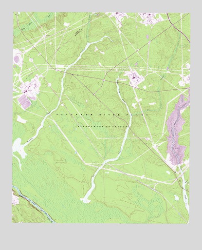
Girard NW, SC USGS Topographic Map
Click on map above to begin viewing in our Map Viewer.

This topographic map contains these locations and features:
Feature Name Type Latitude Longitude GNIS ID View Map
Ashley Place (historical)Populated PlaceN33.1682°W81.6457°1235410View Map
Beaverdam CreekStreamN33.1263°W81.7218°311002View Map
Blue BluffCliffN33.1296°W81.7276°311542View Map
Brinleys Mill (historical)LocaleN33.2221°W81.7040°1235436View Map
Cassels Fire TowerLocaleN33.2360°W81.7162°1731891View Map
Castles Pond (historical)ReservoirN33.1829°W81.7290°1235447View Map
Chandler LandingLocaleN33.1363°W81.7351°347956View Map
Daisy May Church (historical)ChurchN33.2293°W81.6596°1235453View Map
Four Mile Church (historical)ChurchN33.1885°W81.7232°1235475View Map
Four Mile School (historical)SchoolN33.1960°W81.7137°1235476View Map
Fourmile BranchStreamN33.1479°W81.7498°1247816View Map
Friendship Church (historical)ChurchN33.1896°W81.7218°1242273View Map
Griffins Store (historical)LocaleN33.1454°W81.6387°1235487View Map
Indian Grave BranchStreamN33.1890°W81.6665°1223441View Map
Leigh (historical)Populated PlaceN33.1965°W81.7151°1235501View Map
Long Branch School (historical)SchoolN33.2493°W81.6465°1235505View Map
Meyers BranchStreamN33.1488°W81.6282°1220108View Map
Park School (historical)SchoolN33.2157°W81.7312°1235520View Map
Parks Church (historical)ChurchN33.1807°W81.6712°1242274View Map
Robbins (historical)Populated PlaceN33.1510°W81.6551°1235528View Map
Robbins StationLocaleN33.1482°W81.6562°1731904View Map
Saint Luke Church (historical)ChurchN33.1432°W81.6304°1235533View Map
Srp Number 16-403-D D-3073 DamDamN33.1985°W81.7432°1239747View Map
Srp Number 18-488-10 D-3077 DamDamN33.1968°W81.7282°1239748View Map
Steel Creek School (historical)SchoolN33.1443°W81.6304°1242277View Map
Substation Number 1LocaleN33.2363°W81.7271°1731898View Map
Substation Number 3LocaleN33.1710°W81.6490°1731905View Map
Vegp Visitor Center HeliportAirportN33.1252°W81.7454°351950View Map

Note: Coordinates in the location and feature list above are referenced to NAD83 datum.


Copyright (C) 2008-2024 Ryan Niemi / Sunset Dynamics ... All Rights Reserved