TopoQuest Logo
Do you find TopoQuest useful?
Help keep TopoQuest running and adding new maps/features by donating!
Bitcoin:  19c7KJd3qBynnjoSw5npx9KScwjBe4ifkT
Litecoin:  LXs6TkuXGGXo1vDsWCkWVdjQX94eUKd6ui
Home View Maps Find Maps Find Places Resources & Links


Gilmore, Alabama Topographic Map

USGS Map Title: Gilmore, AL
USGS Map MRC: 33087E2
DRG (GeoTIFF) Download: o33087e2.tif


Neighboring USGS Topographic Map Quads:


  Parrish, AL  
33087F3
 

  Goodsprings, AL  
33087F2
 

  Dora, AL  
33087F1
 

  Tutwiler School, AL  
33087E3
 

  Gilmore, AL  
33087E2
 

  Sylvan Springs, AL  
33087E1
 

  Burchfield Store, AL  
33087D3
 

  Oak Grove, AL  
33087D2
 

  Concord, AL  
33087D1


Map MRC Location:

N34°
W88°
N34°
W87°
H8 H7 H6 H5 H4 H3 H2 H1
G8 G7 G6 G5 G4 G3 G2 G1
F8 F7 F6 F5 F4 F3 F2 F1
E8 E7 E6 E5 E4 E3 E2 E1
D8 D7 D6 D5 D4 D3 D2 D1
C8 C7 C6 C5 C4 C3 C2 C1
B8 B7 B6 B5 B4 B3 B2 B1
A8 A7 A6 A5 A4 A3 A2 A1
N33°
W88°
N33°
W87°

Gilmore, AL USGS 1:24K Topographic Map Preview:
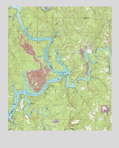
Gilmore, AL USGS Topographic Map
Click on map above to begin viewing in our Map Viewer.

This topographic map contains these locations and features:
Feature Name Type Latitude Longitude GNIS ID View Map
AlliancePopulated PlaceN33.5479°W87.1264°143964View Map
Alliance Elementary SchoolSchoolN33.5454°W87.1256°165348View Map
Beavers PointCapeN33.5459°W87.1778°143992View Map
Big BranchStreamN33.5148°W87.2028°114232View Map
Bill Gross CampLocaleN33.5473°W87.1536°144009View Map
Bills LandingLocaleN33.5554°W87.1814°144010View Map
Birmingport Fire District Station 1BuildingN33.5156°W87.1508°2682786View Map
Bluff CreekStreamN33.5932°W87.1972°114607View Map
Bluff Creek CampLocaleN33.5943°W87.1950°114613View Map
Boyds LandingLocaleN33.5596°W87.1494°144021View Map
Burneys CampLocaleN33.5432°W87.1681°144043View Map
Busby HollowValleyN33.6246°W87.2464°115291View Map
Camp OliverLocaleN33.5334°W87.2339°115473View Map
Canaan BranchStreamN33.6082°W87.2436°151715View Map
Clevengers MarinaLocaleN33.5326°W87.2264°144102View Map
Coal Bed CreekStreamN33.5379°W87.2192°116299View Map
Coal CreekStreamN33.5790°W87.1544°116302View Map
Cook Ford (historical)CrossingN33.5568°W87.1764°154234View Map
Copeland Ferry Pumpkin Center Fire DepartmentBuildingN33.6215°W87.1527°2683007View Map
Davis CampLocaleN33.5646°W87.1789°117108View Map
Donaldson Correctional FacilityBuildingN33.5140°W87.1848°2739749View Map
Double BranchStreamN33.5537°W87.1514°117406View Map
Double Branch FordCrossingN33.5548°W87.1522°144138View Map
DriftwoodPopulated PlaceN33.5257°W87.2375°144139View Map
Drip Spring HollowValleyN33.5312°W87.1581°117475View Map
Dug Hill CemeteryCemeteryN33.5220°W87.1700°144140View Map
Flint RidgeRidgeN33.6079°W87.2056°118435View Map
Fork ShoalsBarN33.5551°W87.1858°151537View Map
Franklin Ferry (historical)CrossingN33.5282°W87.2397°157376View Map
Franklin Ferry BridgeBridgeN33.5268°W87.2406°118599View Map
Fred Vines CampLocaleN33.5607°W87.1775°144214View Map
Frileys CreekStreamN33.5401°W87.2269°118721View Map
GilmorePopulated PlaceN33.5165°W87.1467°118972View Map
Gilmore MineMineN33.5251°W87.1333°146185View Map
Glaze CreekStreamN33.5448°W87.1731°151793View Map
Glaze Ferry (historical)CrossingN33.5509°W87.1672°163276View Map
Gutters BranchStreamN33.5434°W87.1792°119520View Map
Heard Shoal CemeteryCemeteryN33.5357°W87.2481°1730130View Map
Heard Shoal ChurchChurchN33.5351°W87.2483°119915View Map
Heard Shoal School (historical)SchoolN33.5357°W87.2486°142362View Map
Heard ShoalsBarN33.5321°W87.2389°154220View Map
Hopewell ChurchChurchN33.5951°W87.1583°120377View Map
Howton CampLocaleN33.5562°W87.1800°120489View Map
Hurricane CreekStreamN33.5123°W87.2472°120593View Map
Jasper FordCrossingN33.5693°W87.1444°144306View Map
Kisner SloughStreamN33.6032°W87.2339°121261View Map
Kitty BranchStreamN33.5426°W87.2039°121263View Map
Knights Mill (historical)LocaleN33.5271°W87.2422°151623View Map
Leeann BendBendN33.5193°W87.2039°121476View Map
Lightfoot BranchStreamN33.6021°W87.2472°121608View Map
Lily ShoalsBarN33.5443°W87.2050°151538View Map
Little ShoalPopulated PlaceN33.5009°W87.2486°121889View Map
Lock Number Thirteen (historical)DamN33.5512°W87.1883°151541View Map
Locust ForkStreamN33.5571°W87.1858°1901223View Map
Lost CreekStreamN33.6232°W87.2383°160007View Map
MaxinePopulated PlaceN33.5779°W87.1489°122402View Map
Maxine BridgeBridgeN33.5743°W87.1428°122403View Map
Maxine Elementary School (historical)SchoolN33.5959°W87.1558°169337View Map
Maxine MineMineN33.5848°W87.1556°146188View Map
Maxine MinesMineN33.6084°W87.1903°142391View Map
Maxine Tailings Pond DamDamN33.5834°W87.1517°131619View Map
McCarty FordCrossingN33.5834°W87.1317°144367View Map
McCartys Ferry (historical)CrossingN33.5832°W87.1322°151539View Map
Miller Ferry (historical)CrossingN33.6007°W87.2300°151566View Map
Miller SloughStreamN33.6012°W87.2283°122834View Map
Mulberry ForkStreamN33.5571°W87.1875°123577View Map
Panther BranchStreamN33.5018°W87.1772°124406View Map
Perry BranchStreamN33.5440°W87.2078°124619View Map
Pine Grove ChurchChurchN33.5032°W87.2211°124797View Map
Pineywoods CampLocaleN33.5537°W87.1500°152948View Map
Pleasant Hill ChurchChurchN33.5251°W87.1953°125003View Map
Praco MineMineN33.5848°W87.1500°146187View Map
Praco Mine Number 7MineN33.6057°W87.1333°146186View Map
Prescott CemeteryCemeteryN33.5859°W87.1861°125248View Map
Prescott CreekStreamN33.5612°W87.1808°153060View Map
Richardson (historical)LocaleN33.5576°W87.2022°164523View Map
Richardson HollowValleyN33.6143°W87.2439°125612View Map
Richardson SloughStreamN33.6168°W87.2394°125615View Map
Riverdale Landing CampLocaleN33.5723°W87.1275°144503View Map
Riverside ChurchChurchN33.5546°W87.1814°125670View Map
Riverside MineMineN33.5515°W87.2139°163178View Map
Riverview CampLocaleN33.5829°W87.1361°144505View Map
Riverwood LodgeLocaleN33.5751°W87.2022°153162View Map
Rocky BranchStreamN33.5654°W87.2014°125802View Map
Sanford Ferry (historical)CrossingN33.6179°W87.2372°154223View Map
Satterfield CampLocaleN33.5276°W87.2258°126427View Map
Sextons BranchStreamN33.5046°W87.2008°126569View Map
Short CreekStreamN33.5390°W87.2406°126811View Map
Skelton CreekStreamN33.5834°W87.1292°153462View Map
Snow Ferry (historical)CrossingN33.5762°W87.2050°154224View Map
Snow School (historical)SchoolN33.6079°W87.2036°142438View Map
Tailings Pond Number 2ReservoirN33.5863°W87.1522°131618View Map
Taylor Ferry (historical)CrossingN33.5493°W87.2000°140331View Map
Taylor Ferry CampLocaleN33.5446°W87.2017°153661View Map
Thomas FordCrossingN33.5084°W87.2078°1987082View Map
Thompson BendBendN33.5904°W87.2000°142444View Map
Tucker RidgeRidgeN33.5365°W87.1722°128116View Map
Turkey BranchStreamN33.5054°W87.1756°128133View Map
Two Branch Ferry (historical)CrossingN33.5571°W87.1856°142450View Map
Valley CreekStreamN33.5371°W87.2300°128387View Map
Vines CampLocaleN33.5490°W87.1672°153855View Map
Warrior River Fire and Rescue ServiceBuildingN33.5039°W87.2212°2683324View Map
Weaver CemeteryCemeteryN33.5118°W87.1483°140385View Map
West Jefferson DivisionCivilN33.5754°W87.1436°165828View Map
White BranchStreamN33.5754°W87.2069°128858View Map
Wilderness GardenPopulated PlaceN33.5654°W87.1281°140403View Map
Winters CampLocaleN33.5748°W87.1511°140411View Map
Yeargins CampLocaleN33.5362°W87.2314°140422View Map

Note: Coordinates in the location and feature list above are referenced to NAD83 datum.


Copyright (C) 2008-2024 Ryan Niemi / Sunset Dynamics ... All Rights Reserved