TopoQuest Logo
Do you find TopoQuest useful?
Help keep TopoQuest running and adding new maps/features by donating!
Bitcoin:  19c7KJd3qBynnjoSw5npx9KScwjBe4ifkT
Litecoin:  LXs6TkuXGGXo1vDsWCkWVdjQX94eUKd6ui
Home View Maps Find Maps Find Places Resources & Links


Gilmore, Idaho Topographic Map

USGS Map Title: Gilmore, ID
USGS Map MRC: 44113D3
DRG (GeoTIFF) Download: o44113d3.tif


Neighboring USGS Topographic Map Quads:


  Sheephorn Peak, ID  
44113E4
 

  Purcell Spring, ID  
44113E3
 

  Powderhorn Gulch, ID  
44113E2
 

  Iron Creek Point, ID  
44113D4
 

  Gilmore, ID  
44113D3
 

  Gilmore Summit, ID  
44113D2
 

  Moffett Springs, ID  
44113C4
 

  Big Windy Peak, ID  
44113C3
 

  Coal Kiln Canyon, ID  
44113C2


Map MRC Location:

N45°
W114°
N45°
W113°
H8 H7 H6 H5 H4 H3 H2 H1
G8 G7 G6 G5 G4 G3 G2 G1
F8 F7 F6 F5 F4 F3 F2 F1
E8 E7 E6 E5 E4 E3 E2 E1
D8 D7 D6 D5 D4 D3 D2 D1
C8 C7 C6 C5 C4 C3 C2 C1
B8 B7 B6 B5 B4 B3 B2 B1
A8 A7 A6 A5 A4 A3 A2 A1
N44°
W114°
N44°
W113°

Gilmore, ID USGS 1:24K Topographic Map Preview:
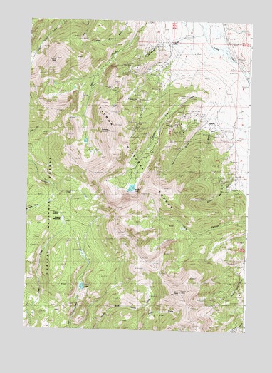
Gilmore, ID USGS Topographic Map
Click on map above to begin viewing in our Map Viewer.

This topographic map contains these locations and features:
Feature Name Type Latitude Longitude GNIS ID View Map
Brown Bull MineMineN44.4710°W113.3272°378261View Map
Federal GulchValleyN44.4616°W113.2725°399022View Map
Firbox MeadowsFlatN44.4030°W113.3559°381711View Map
Firebox MeadowsFlatN44.4188°W113.3542°393862View Map
Firebox SummitGapN44.4219°W113.3553°396488View Map
GilmorePopulated PlaceN44.4588°W113.2697°396550View Map
Hilltop MineMineN44.4813°W113.3192°383210View Map
Iron Dyke MineMineN44.4633°W113.3111°383755View Map
Latest Out MineMineN44.4574°W113.2928°384466View Map
Liberty GulchValleyN44.4619°W113.2684°384603View Map
Long CanyonValleyN44.4313°W113.2506°386032View Map
Meadow LakeReservoirN44.4323°W113.3160°386716View Map
Meadow Lake CampgroundLocaleN44.4338°W113.3175°394393View Map
Meadow Lake CreekStreamN44.4735°W113.2500°386717View Map
Mill Creek LakeReservoirN44.3922°W113.3429°397912View Map
Mountain Boy MineMineN44.4583°W113.3128°387284View Map
Negro PeakSummitN44.4835°W113.3611°387498View Map
Portland MineMineN44.4652°W113.3289°388788View Map
Portland MountainSummitN44.4552°W113.3300°388790View Map
Ridgeway MineMineN44.4674°W113.3128°389357View Map
Sheep MountainSummitN44.3905°W113.2872°390240View Map
Shortys GulchValleyN44.4557°W113.2692°390372View Map
Silver Moon GulchValleyN44.4360°W113.2581°390449View Map
Sourdough GulchValleyN44.4938°W113.2875°390843View Map

Note: Coordinates in the location and feature list above are referenced to NAD83 datum.


Copyright (C) 2008-2024 Ryan Niemi / Sunset Dynamics ... All Rights Reserved