TopoQuest Logo
Do you find TopoQuest useful?
Help keep TopoQuest running and adding new maps/features by donating!
Bitcoin:  19c7KJd3qBynnjoSw5npx9KScwjBe4ifkT
Litecoin:  LXs6TkuXGGXo1vDsWCkWVdjQX94eUKd6ui
Home View Maps Find Maps Find Places Resources & Links


Frogner, Minnesota Topographic Map

USGS Map Title: Frogner, MN
USGS Map MRC: 46092E3
DRG (GeoTIFF) Download: o46092e3.tif


Neighboring USGS Topographic Map Quads:


  Cloquet, MN  
46092F4
 

  Esko, MN  
46092F3
 

  West Duluth, MN  
46092F2
 

  Wrenshall, MN  
46092E4
 

  Frogner, MN  
46092E3
 

  Borea, WI  
46092E2
 

  Holyoke, MN  
46092D4
 

  Foxboro, WI  
46092D3
 

  Patzau, WI  
46092D2


Map MRC Location:

N47°
W93°
N47°
W92°
H8 H7 H6 H5 H4 H3 H2 H1
G8 G7 G6 G5 G4 G3 G2 G1
F8 F7 F6 F5 F4 F3 F2 F1
E8 E7 E6 E5 E4 E3 E2 E1
D8 D7 D6 D5 D4 D3 D2 D1
C8 C7 C6 C5 C4 C3 C2 C1
B8 B7 B6 B5 B4 B3 B2 B1
A8 A7 A6 A5 A4 A3 A2 A1
N46°
W93°
N46°
W92°

Frogner, MN USGS 1:24K Topographic Map Preview:
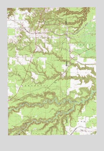
Frogner, MN USGS Topographic Map
Click on map above to begin viewing in our Map Viewer.

This topographic map contains these locations and features:
Feature Name Type Latitude Longitude GNIS ID View Map
Barker (historical)LocaleN46.6006°W92.3250°2074119View Map
Barker Post Office (historical)Post OfficeN46.6006°W92.3250°2074120View Map
Deer CreekStreamN46.5241°W92.3735°642715View Map
Foxboro SchoolSchoolN46.5041°W92.2716°1565240View Map
FrognerPopulated PlaceN46.5541°W92.3066°654715View Map
Little Net RiverStreamN46.5022°W92.3591°646867View Map
Net RiverStreamN46.5116°W92.3469°648495View Map
Rock CreekStreamN46.5363°W92.3085°650187View Map
Section Thirty-six CreekStreamN46.5183°W92.3066°651827View Map
South Fork Nemadji RiverStreamN46.5322°W92.2816°652297View Map
South Fork Nemadji RiverStreamN46.5319°W92.2816°1574450View Map
State LineLocaleN46.5994°W92.2919°652586View Map
State LineLocaleN46.5994°W92.2919°1574828View Map
State Line CreekStreamN46.5211°W92.2935°652588View Map
Township of Silver BrookCivilN46.6152°W92.3524°665612View Map
Township of WrenshallCivilN46.5476°W92.3582°666055View Map

Note: Coordinates in the location and feature list above are referenced to NAD83 datum.


Copyright (C) 2008-2024 Ryan Niemi / Sunset Dynamics ... All Rights Reserved