TopoQuest Logo
Do you find TopoQuest useful?
Help keep TopoQuest running and adding new maps/features by donating!
Bitcoin:  19c7KJd3qBynnjoSw5npx9KScwjBe4ifkT
Litecoin:  LXs6TkuXGGXo1vDsWCkWVdjQX94eUKd6ui
Home View Maps Find Maps Find Places Resources & Links


Friendsville, Pennsylvania Topographic Map

USGS Map Title: Friendsville, PA
USGS Map MRC: 41076H1
DRG (GeoTIFF) Download: o41076h1.tif


Neighboring USGS Topographic Map Quads:


  Apalachin, NY  
42076A2
 

  Endicott, NY  
42076A1
 

  Binghamton West, NY  
42075A8
 

  Little Meadows, PA  
41076H2
 

  Friendsville, PA  
41076H1
 

  Laurel Lake, PA  
41075H8
 

  Le Raysville, PA  
41076G2
 

  Lawton, PA  
41076G1
 

  Montrose West, PA  
41075G8


Map MRC Location:

N42°
W77°
N42°
W76°
H8 H7 H6 H5 H4 H3 H2 H1
G8 G7 G6 G5 G4 G3 G2 G1
F8 F7 F6 F5 F4 F3 F2 F1
E8 E7 E6 E5 E4 E3 E2 E1
D8 D7 D6 D5 D4 D3 D2 D1
C8 C7 C6 C5 C4 C3 C2 C1
B8 B7 B6 B5 B4 B3 B2 B1
A8 A7 A6 A5 A4 A3 A2 A1
N41°
W77°
N41°
W76°

Friendsville, PA USGS 1:24K Topographic Map Preview:
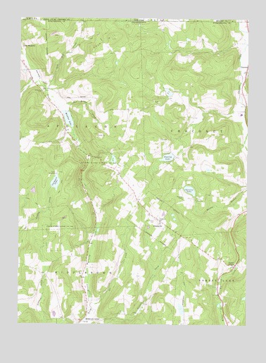
Friendsville, PA USGS Topographic Map
Click on map above to begin viewing in our Map Viewer.

This topographic map contains these locations and features:
Feature Name Type Latitude Longitude GNIS ID View Map
Baldwin CreekStreamN41.8773°W76.0871°1168653View Map
Borough of FriendsvilleCivilN41.9179°W76.0477°1215608View Map
Bow Bridge CreekStreamN41.9640°W76.1021°1170041View Map
Camp ArrowheadLocaleN41.9365°W76.1035°1170974View Map
Camp ChoconutLocaleN41.9273°W76.0255°1170993View Map
Carmault LakeLakeN41.9329°W76.1048°1171221View Map
Choconut ChapelChurchN41.9265°W76.0341°1171796View Map
Choconut LakeReservoirN41.9302°W76.0311°1171798View Map
Cork HillSummitN41.9917°W76.0727°1172454View Map
Cork Hill CreekStreamN41.9720°W76.1119°970036View Map
Courtland Birchard PondReservoirN41.8815°W76.0353°1195828View Map
FriendsvillePopulated PlaceN41.9170°W76.0455°1175271View Map
Friendsville Post OfficePost OfficeN41.9184°W76.0470°2773143View Map
Lee CreekStreamN41.8837°W76.0841°1179112View Map
Middletown CenterPopulated PlaceN41.8762°W76.0899°1204166View Map
Minkler LakeReservoirN41.9590°W76.0981°1181343View Map
Minkler Lake DamDamN41.9617°W76.1013°1195873View Map
Rush Volunteer Fire Department Station 2BuildingN41.8928°W76.0448°2653494View Map
Saint Francis CemeteryCemeteryN41.9181°W76.0488°1185941View Map
Saint Francis ChurchChurchN41.9179°W76.0463°1185943View Map
Saint Thomas CemeteryCemeteryN41.9704°W76.1123°1186748View Map
Stanley LakeLakeN41.9435°W76.0433°1188396View Map
Stanley Lake DamDamN41.9617°W76.0396°1195872View Map
State Game Lands Number 140ParkN41.9417°W76.0830°1208348View Map
Stone Lake DamDamN41.8801°W76.0346°1195829View Map
Stonestreet CemeteryCemeteryN41.8756°W76.0335°1197380View Map
Township of ApolaconCivilN41.9539°W76.0968°1217244View Map
Township of ChoconutCivilN41.9581°W76.0210°1217245View Map
Turrell CornersLocaleN41.8998°W76.0049°1189971View Map

Note: Coordinates in the location and feature list above are referenced to NAD83 datum.


Copyright (C) 2008-2024 Ryan Niemi / Sunset Dynamics ... All Rights Reserved