TopoQuest Logo
Do you find TopoQuest useful?
Help keep TopoQuest running and adding new maps/features by donating!
Bitcoin:  19c7KJd3qBynnjoSw5npx9KScwjBe4ifkT
Litecoin:  LXs6TkuXGGXo1vDsWCkWVdjQX94eUKd6ui
Home View Maps Find Maps Find Places Resources & Links


Friend, Nebraska Topographic Map

USGS Map Title: Friend, NE
USGS Map MRC: 40097F3
DRG (GeoTIFF) Download: o40097f3.tif


Neighboring USGS Topographic Map Quads:


  Utica SW, NE  
40097G4
 

  Beaver Crossing, NE  
40097G3
 

  Goehner, NE  
40097G2
 

  Exeter, NE  
40097F4
 

  Friend, NE  
40097F3
 

  Dorchester NW, NE  
40097F2
 

  Friend SW, NE  
40097E4
 

  Friend SE, NE  
40097E3
 

  Dorchester SW, NE  
40097E2


Map MRC Location:

N41°
W98°
N41°
W97°
H8 H7 H6 H5 H4 H3 H2 H1
G8 G7 G6 G5 G4 G3 G2 G1
F8 F7 F6 F5 F4 F3 F2 F1
E8 E7 E6 E5 E4 E3 E2 E1
D8 D7 D6 D5 D4 D3 D2 D1
C8 C7 C6 C5 C4 C3 C2 C1
B8 B7 B6 B5 B4 B3 B2 B1
A8 A7 A6 A5 A4 A3 A2 A1
N40°
W98°
N40°
W97°

Friend, NE USGS 1:24K Topographic Map Preview:
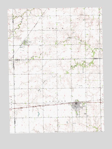
Friend, NE USGS Topographic Map
Click on map above to begin viewing in our Map Viewer.

This topographic map contains these locations and features:
Feature Name Type Latitude Longitude GNIS ID View Map
Andrew CemeteryCemeteryN40.6411°W97.2720°826994View Map
Burley ParkParkN40.6422°W97.2870°827789View Map
City of FriendCivilN40.6505°W97.2838°2394827View Map
CordovaPopulated PlaceN40.7172°W97.3531°828338View Map
Cordova (historical)LocaleN40.7167°W97.3553°1881922View Map
Cordova Post OfficePost OfficeN40.7174°W97.3527°1881919View Map
Cordova Volunteer Fire DepartmentBuildingN40.7170°W97.3526°1881921View Map
Dorchester Farmers Co-op ElevatorLocaleN40.7172°W97.3531°1881920View Map
Election Precinct MCivilN40.7421°W97.3112°1929214View Map
Farmers Union Cooperative Company ElevatorLocaleN40.6547°W97.2867°1882502View Map
FriendLocaleN40.6553°W97.2864°1882505View Map
FriendPopulated PlaceN40.6536°W97.2862°829421View Map
Friend Berean ChurchChurchN40.6531°W97.2881°1882507View Map
Friend Christian AssemblyChurchN40.6545°W97.2764°1882511View Map
Friend Country ClubLocaleN40.6472°W97.2823°1882517View Map
Friend Election PrecinctCivilN40.6550°W97.3121°1928883View Map
Friend Medical CenterHospitalN40.6539°W97.2784°1882514View Map
Friend ParkParkN40.6450°W97.2859°1882506View Map
Friend Police DepartmentBuildingN40.6530°W97.2867°1882503View Map
Friend Post OfficePost OfficeN40.6540°W97.2852°1882504View Map
Friend Public SchoolsSchoolN40.6508°W97.2881°1882516View Map
Friend Volunteer Fire DepartmentBuildingN40.6529°W97.2868°1882512View Map
Gilbert Public LibraryBuildingN40.6542°W97.2859°1882513View Map
Johnson Creek CemeteryCemeteryN40.6961°W97.2734°830390View Map
Leland CemeteryCemeteryN40.7353°W97.3098°830673View Map
Leonard CemeteryCemeteryN40.7425°W97.2742°830678View Map
Milton DamDamN40.6904°W97.2586°1767250View Map
Milton ReservoirLakeN40.6895°W97.2580°1767251View Map
North Fork Johnson CreekStreamN40.7070°W97.2634°831693View Map
Potter-Reich DamDamN40.6800°W97.2987°1766843View Map
Potter-Reich ReservoirReservoirN40.6800°W97.2987°1766844View Map
Precinct M, Cordova Election Precinct (historical)CivilN40.7422°W97.2520°1929216View Map
Saint Johns Lutheran ChurchChurchN40.7172°W97.3531°1881916View Map
Saint Josephs Catholic ChurchChurchN40.6514°W97.2884°1882508View Map
Saint Josephs CemeteryCemeteryN40.6339°W97.2920°832952View Map
South Fork Johnson CreekStreamN40.7070°W97.2637°833589View Map
Township MCivilN40.7417°W97.3087°1881774View Map
Township of FriendCivilN40.6528°W97.3087°1882313View Map
United Church of ChristChurchN40.6533°W97.2850°1882510View Map
United Methodist ChurchChurchN40.6495°W97.2862°1882509View Map
Village of CordovaCivilN40.7164°W97.3516°2398627View Map
Warren Memorial HospitalHospitalN40.6532°W97.2818°1882515View Map
Zastrow CemeteryCemeteryN40.7128°W97.3303°834922View Map

Note: Coordinates in the location and feature list above are referenced to NAD83 datum.


Copyright (C) 2008-2024 Ryan Niemi / Sunset Dynamics ... All Rights Reserved