TopoQuest Logo
Do you find TopoQuest useful?
Help keep TopoQuest running and adding new maps/features by donating!
Bitcoin:  19c7KJd3qBynnjoSw5npx9KScwjBe4ifkT
Litecoin:  LXs6TkuXGGXo1vDsWCkWVdjQX94eUKd6ui
Home View Maps Find Maps Find Places Resources & Links


Freeman, North Carolina Topographic Map

USGS Map Title: Freeman, NC
USGS Map MRC: 34078C3
DRG (GeoTIFF) Download: o34078c3.tif


Neighboring USGS Topographic Map Quads:


  Council, NC  
34078D4
 

  Kelly, NC  
34078D3
 

  Point Caswell, NC  
34078D2
 

  Lake Waccamaw East, NC  
34078C4
 

  Freeman, NC  
34078C3
 

  Acme, NC  
34078C2
 

  Juniper Creek, NC  
34078B4
 

  Honey Island, NC  
34078B3
 

  Lewis Swamp, NC  
34078B2


Map MRC Location:

N35°
W79°
N35°
W78°
H8 H7 H6 H5 H4 H3 H2 H1
G8 G7 G6 G5 G4 G3 G2 G1
F8 F7 F6 F5 F4 F3 F2 F1
E8 E7 E6 E5 E4 E3 E2 E1
D8 D7 D6 D5 D4 D3 D2 D1
C8 C7 C6 C5 C4 C3 C2 C1
B8 B7 B6 B5 B4 B3 B2 B1
A8 A7 A6 A5 A4 A3 A2 A1
N34°
W79°
N34°
W78°

Freeman, NC USGS 1:24K Topographic Map Preview:
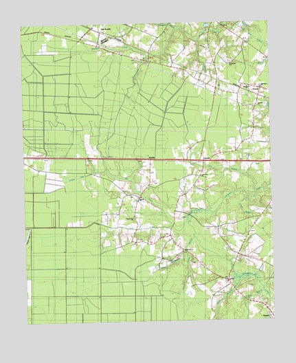
Freeman, NC USGS Topographic Map
Click on map above to begin viewing in our Map Viewer.

This topographic map contains these locations and features:
Feature Name Type Latitude Longitude GNIS ID View Map
Abraham ChurchChurchN34.3402°W78.2558°1004506View Map
Acme Delco Elementary SchoolSchoolN34.3612°W78.3176°1004508View Map
ArmourPopulated PlaceN34.3471°W78.2542°1018851View Map
Big BaySwampN34.3377°W78.2947°981305View Map
Bitch BaySwampN34.2760°W78.3131°981506View Map
Black BaySwampN34.3338°W78.3692°981510View Map
Boggy BranchStreamN34.2679°W78.2683°1025174View Map
Broadwater LakeLakeN34.3018°W78.2583°981956View Map
Buzzard BaySwampN34.2738°W78.3222°982347View Map
ByrdvillePopulated PlaceN34.3179°W78.3111°1006151View Map
Cheerful Hope ChurchChurchN34.2932°W78.3197°983067View Map
Coopersmith BranchStreamN34.3613°W78.3117°1025256View Map
Dans CreekStreamN34.2902°W78.2997°983951View Map
FreemanPopulated PlaceN34.3171°W78.2842°1020362View Map
Hall BranchStreamN34.3046°W78.2575°1025365View Map
Johns BranchStreamN34.2854°W78.2892°1025430View Map
Lateral Canal ECanalN34.2602°W78.3722°988156View Map
Lateral Canal FCanalN34.2577°W78.3550°988157View Map
Lateral Canal GCanalN34.2524°W78.3372°988158View Map
Lennon CemeteryCemeteryN34.2646°W78.2622°988350View Map
Livingston ChurchChurchN34.2671°W78.2731°1004503View Map
Malpass CemeteryCemeteryN34.2846°W78.3172°989264View Map
McClennen BranchStreamN34.2682°W78.2803°1025516View Map
Mill CreekStreamN34.2943°W78.2919°989903View Map
Mount Pleasant CemeteryCemeteryN34.3577°W78.2697°990522View Map
Mount Pleasant ChurchChurchN34.3479°W78.2611°1004507View Map
Piney Grove ChurchChurchN34.2791°W78.2953°1004504View Map
Poplar BranchStreamN34.2629°W78.2556°992678View Map
ProsperPopulated PlaceN34.2521°W78.2508°1006340View Map
Red Hill ChurchChurchN34.3024°W78.3172°993112View Map
Scott BranchStreamN34.2629°W78.2547°1025687View Map
Simon BranchStreamN34.3052°W78.2653°994846View Map
Strauss CanalCanalN34.3102°W78.3506°995606View Map
Strauss SwampSwampN34.3063°W78.3619°995607View Map
Taylor BranchStreamN34.2791°W78.2933°995877View Map
Terrapin BranchStreamN34.2671°W78.2514°1025745View Map
Town of SandyfieldCivilN34.3743°W78.2996°2407285View Map
Township of RansomCivilN34.3053°W78.2680°1026578View Map
Turkeypen BranchStreamN34.3729°W78.2958°996349View Map
Turner BranchStreamN34.3682°W78.2856°996356View Map
Union Grove ChurchChurchN34.3107°W78.2856°1004505View Map

Note: Coordinates in the location and feature list above are referenced to NAD83 datum.


Copyright (C) 2008-2024 Ryan Niemi / Sunset Dynamics ... All Rights Reserved