TopoQuest Logo
Do you find TopoQuest useful?
Help keep TopoQuest running and adding new maps/features by donating!
Bitcoin:  19c7KJd3qBynnjoSw5npx9KScwjBe4ifkT
Litecoin:  LXs6TkuXGGXo1vDsWCkWVdjQX94eUKd6ui
Home View Maps Find Maps Find Places Resources & Links


Franklin, Alabama Topographic Map

USGS Map Title: Franklin, AL
USGS Map MRC: 31087F4
DRG (GeoTIFF) Download: o31087f4.tif


Neighboring USGS Topographic Map Quads:


  Lower Peach Tree, AL  
31087G5
 

  Hybart, AL  
31087G4
 

  Vredenburgh, AL  
31087G3
 

  Chance, AL  
31087F5
 

  Franklin, AL  
31087F4
 

  Natchez, AL  
31087F3
 

  Claiborne, AL  
31087E5
 

  Mexia, AL  
31087E4
 

  Monroeville, AL  
31087E3


Map MRC Location:

N32°
W88°
N32°
W87°
H8 H7 H6 H5 H4 H3 H2 H1
G8 G7 G6 G5 G4 G3 G2 G1
F8 F7 F6 F5 F4 F3 F2 F1
E8 E7 E6 E5 E4 E3 E2 E1
D8 D7 D6 D5 D4 D3 D2 D1
C8 C7 C6 C5 C4 C3 C2 C1
B8 B7 B6 B5 B4 B3 B2 B1
A8 A7 A6 A5 A4 A3 A2 A1
N31°
W88°
N31°
W87°

Franklin, AL USGS 1:24K Topographic Map Preview:
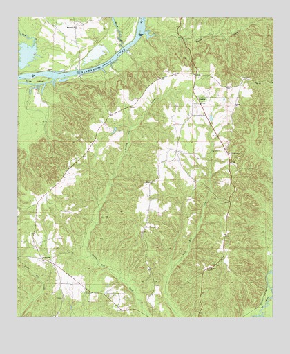
Franklin, AL USGS Topographic Map
Click on map above to begin viewing in our Map Viewer.

This topographic map contains these locations and features:
Feature Name Type Latitude Longitude GNIS ID View Map
Bates BarBarN31.7435°W87.4414°113561View Map
Beaver CreekStreamN31.7432°W87.4394°113722View Map
Bryant CemeteryCemeteryN31.6277°W87.4480°154581View Map
Bryant-Deer CemeteryCemeteryN31.6490°W87.4014°155395View Map
Davis FerryCrossingN31.7260°W87.4697°117128View Map
Eureka Baptist ChurchChurchN31.6354°W87.4655°151763View Map
Faith ChapelChurchN31.6815°W87.4358°118159View Map
Finchburg Volunteer Fire DepartmentBuildingN31.6278°W87.4498°2691212View Map
Forehand African Methodist Episcopal ChurchChurchN31.6327°W87.4778°118485View Map
Forehand CemeteryCemeteryN31.6324°W87.4772°1805649View Map
FranklinPopulated PlaceN31.7146°W87.4114°118595View Map
Franklin ChurchChurchN31.6704°W87.4353°154582View Map
Franklin ChurchChurchN31.7140°W87.4105°154583View Map
Franklin Post OfficePost OfficeN31.7144°W87.4124°167010View Map
Franklin Volunteer Fire DepartmentBuildingN31.7000°W87.4008°2691543View Map
Haines IslandIslandN31.7238°W87.4919°119550View Map
Haines Island ParkParkN31.7246°W87.4694°136533View Map
Johnson Woodyard LandingLocaleN31.7407°W87.4405°136546View Map
Leggett LandingLocaleN31.7277°W87.4828°156595View Map
McLeod CreekStreamN31.7371°W87.4494°152287View Map
Miles ChapelChurchN31.7460°W87.4730°122723View Map
Mount Ararat ChurchChurchN31.6452°W87.4053°152392View Map
Pilgrim Rest ChurchChurchN31.6488°W87.4861°136602View Map
Saint Peter Baptist ChurchChurchN31.7129°W87.3933°126194View Map
Saint Peter CemeteryCemeteryN31.7129°W87.3925°1805509View Map
Scratch AnklePopulated PlaceN31.6627°W87.4375°126495View Map
Spring Hill ChurchChurchN31.6985°W87.3967°136637View Map
Springhill Baptist ChurchChurchN31.6935°W87.3953°127251View Map
Springhill CemeteryCemeteryN31.6929°W87.3953°1805616View Map
Vredenburgh DivisionCivilN31.7169°W87.4139°165903View Map
WainwrightPopulated PlaceN31.6490°W87.4869°157207View Map
York CemeteryCemeteryN31.7251°W87.3897°154052View Map
York ChapelChurchN31.7252°W87.3903°136653View Map

Note: Coordinates in the location and feature list above are referenced to NAD83 datum.


Copyright (C) 2008-2024 Ryan Niemi / Sunset Dynamics ... All Rights Reserved