TopoQuest Logo
Do you find TopoQuest useful?
Help keep TopoQuest running and adding new maps/features by donating!
Bitcoin:  19c7KJd3qBynnjoSw5npx9KScwjBe4ifkT
Litecoin:  LXs6TkuXGGXo1vDsWCkWVdjQX94eUKd6ui
Home View Maps Find Maps Find Places Resources & Links


Fowlerville, Michigan Topographic Map

USGS Map Title: Fowlerville, MI
USGS Map MRC: 42084F1
DRG (GeoTIFF) Download: o42084f1.tif


Neighboring USGS Topographic Map Quads:


  Perry, MI  
42084G2
 

  Corunna SE, MI  
42084G1
 

  Byron, MI  
42083G8
 

  Webberville, MI  
42084F2
 

  Fowlerville, MI  
42084F1
 

  Oak Grove, MI  
42083F8
 

  Millville, MI  
42084E2
 

  Parkers Corners, MI  
42084E1
 

  Howell, MI  
42083E8


Map MRC Location:

N43°
W85°
N43°
W84°
H8 H7 H6 H5 H4 H3 H2 H1
G8 G7 G6 G5 G4 G3 G2 G1
F8 F7 F6 F5 F4 F3 F2 F1
E8 E7 E6 E5 E4 E3 E2 E1
D8 D7 D6 D5 D4 D3 D2 D1
C8 C7 C6 C5 C4 C3 C2 C1
B8 B7 B6 B5 B4 B3 B2 B1
A8 A7 A6 A5 A4 A3 A2 A1
N42°
W85°
N42°
W84°

Fowlerville, MI USGS 1:24K Topographic Map Preview:
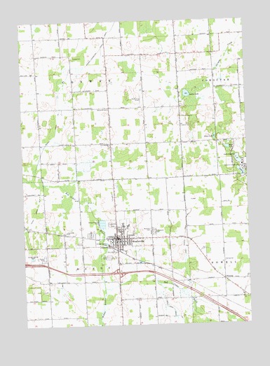
Fowlerville, MI USGS Topographic Map
Click on map above to begin viewing in our Map Viewer.

This topographic map contains these locations and features:
Feature Name Type Latitude Longitude GNIS ID View Map
Alan's Mobile Home ParkPopulated PlaceN42.6528°W84.1139°2630351View Map
Cedar River Estates Mobile Home ParkPopulated PlaceN42.6528°W84.0772°2630352View Map
Chase LakeLakeN42.7020°W84.0175°623126View Map
Conway Benjamin CemeteryCemeteryN42.7139°W84.0767°621099View Map
Conway Drain Number 1CanalN42.7061°W84.1052°1623294View Map
Conway Klein CemeteryCemeteryN42.7353°W84.0952°623719View Map
Cook LakeLakeN42.6873°W84.0032°623738View Map
Coughran CemeteryCemeteryN42.7070°W84.0369°623870View Map
First Baptist ChurchChurchN42.6592°W84.0733°2630339View Map
First Church of the NazareneChurchN42.6650°W84.0639°2630338View Map
First United Methodist ChurchChurchN42.6594°W84.0714°2630336View Map
FlemingPopulated PlaceN42.6436°W84.0133°626152View Map
Fleming Post Office (historical)Post OfficeN42.6436°W84.0133°2631016View Map
FowlervillePopulated PlaceN42.6606°W84.0730°626363View Map
Fowlerville Area Fire DepartmentBuildingN42.6623°W84.0729°2630345View Map
Fowlerville Christian SchoolSchoolN42.6634°W84.1011°626364View Map
Fowlerville Community ParkParkN42.6667°W84.0750°2630332View Map
Fowlerville FairgroundsLocaleN42.6617°W84.0861°2630333View Map
Fowlerville High SchoolSchoolN42.6869°W84.0694°2630347View Map
Fowlerville Junior High SchoolSchoolN42.6704°W84.0678°2630346View Map
Fowlerville Police DepartmentBuildingN42.6593°W84.0728°2630343View Map
Fowlerville Post OfficePost OfficeN42.6612°W84.0544°2630342View Map
Fowlerville StationLocaleN42.6575°W84.0764°2630335View Map
Fowlerville Village HallBuildingN42.6592°W84.0728°2630344View Map
Free Methodist ChurchChurchN42.6992°W84.0755°626452View Map
Grand Shire Estates Mobile Home ParkPopulated PlaceN42.6511°W84.0772°2630353View Map
Greenwood CemeteryCemeteryN42.6630°W84.0524°627379View Map
Handy Drain Number 5CanalN42.6711°W84.1183°1623389View Map
Handy Howell Drain Number 1CanalN42.6625°W84.0350°1623390View Map
Howell School District Number Five Schoolhouse Historical MarkerParkN42.6482°W84.0211°2630869View Map
Interchange 129CrossingN42.6467°W84.0722°2630851View Map
Kreeger Elementary SchoolSchoolN42.6662°W84.0643°2630348View Map
Lake CohoctahLakeN42.6926°W84.0050°623547View Map
Livingston Centre Historical MuseumBuildingN42.6611°W84.0881°2630334View Map
Maple Grove AirportAirportN42.7173°W84.0603°1623902View Map
McAuley-McPherson Family Care CenterBuildingN42.6510°W84.0776°2345401View Map
Middle Branch Red Cedar RiverStreamN42.6395°W84.0811°632239View Map
Mount Olivet CemeteryCemeteryN42.6643°W84.0544°632828View Map
Mud LakeLakeN42.6977°W84.0107°632938View Map
Munn Middle SchoolSchoolN42.6656°W84.0700°2630350View Map
Nazarene CampgroundLocaleN42.6900°W84.0016°633242View Map
Sabine LakeLakeN42.7199°W84.0327°636452View Map
Saint Agnes ChurchChurchN42.6606°W84.0639°2630337View Map
Saint John Lutheran ChurchChurchN42.6597°W84.0667°2630341View Map
Smith Elementary SchoolSchoolN42.6656°W84.0672°2630349View Map
Township of ConwayCivilN42.7316°W84.0955°1626130View Map
Township of HandyCivilN42.6424°W84.0905°1626430View Map
United Brethren in Christ ChurchChurchN42.6625°W84.1000°2630340View Map
Village of FowlervilleCivilN42.6595°W84.0744°2398911View Map
West Howell CemeteryCemeteryN42.6507°W84.0134°626153View Map

Note: Coordinates in the location and feature list above are referenced to NAD83 datum.


Copyright (C) 2008-2024 Ryan Niemi / Sunset Dynamics ... All Rights Reserved