TopoQuest Logo
Do you find TopoQuest useful?
Help keep TopoQuest running and adding new maps/features by donating!
Bitcoin:  19c7KJd3qBynnjoSw5npx9KScwjBe4ifkT
Litecoin:  LXs6TkuXGGXo1vDsWCkWVdjQX94eUKd6ui
Home View Maps Find Maps Find Places Resources & Links


Fort Myers Beach, Florida Topographic Map

USGS Map Title: Fort Myers Beach, FL
USGS Map MRC: 26081D8
DRG (GeoTIFF) Download: o26081d8.tif


Neighboring USGS Topographic Map Quads:


  Pine Island Center, FL  
26082E1
 

  Fort Myers SW, FL  
26081E8
 

  Fort Myers SE, FL  
26081E7
 

  Sanibel, FL  
26082D1
 

  Fort Myers Beach, FL  
26081D8
 

  Estero, FL  
26081D7


  Bonita Springs, FL  
26081C7


Map MRC Location:

N27°
W82°
N27°
W81°
H8 H7 H6 H5 H4 H3 H2 H1
G8 G7 G6 G5 G4 G3 G2 G1
F8 F7 F6 F5 F4 F3 F2 F1
E8 E7 E6 E5 E4 E3 E2 E1
D8 D7 D6 D5 D4 D3 D2 D1
C8 C7 C6 C5 C4 C3 C2 C1
B8 B7 B6 B5 B4 B3 B2 B1
A8 A7 A6 A5 A4 A3 A2 A1
N26°
W82°
N26°
W81°

Fort Myers Beach, FL USGS 1:24K Topographic Map Preview:
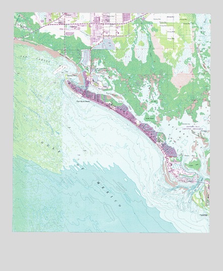
Fort Myers Beach, FL USGS Topographic Map
Click on map above to begin viewing in our Map Viewer.

This topographic map contains these locations and features:
Feature Name Type Latitude Longitude GNIS ID View Map
Aspen Indian Creek ParkPopulated PlaceN26.4901°W81.9412°2448149View Map
Big BayouLakeN26.4942°W81.8793°278621View Map
Big Carlos PassChannelN26.4031°W81.8829°278648View Map
Bodwitch PointCapeN26.4648°W81.9662°279130View Map
Box PointCapeN26.4895°W81.8806°279299View Map
Bunche BeachBeachN26.4759°W81.9673°279669View Map
Carlos PointCapeN26.4054°W81.8890°280038View Map
Coast Guard Station Fort Myers BeachMilitaryN26.4588°W81.9542°2512106View Map
Connie Mack IslandIslandN26.4920°W81.9940°280719View Map
Coon KeyIslandN26.4145°W81.8848°280761View Map
Cow CreekStreamN26.4659°W81.9112°280918View Map
Dog KeyIslandN26.4504°W81.9109°281656View Map
Estero IslandIslandN26.4367°W81.9204°282259View Map
Estero Island DivisionCivilN26.4000°W81.9238°1935758View Map
Estero PassChannelN26.4676°W81.9559°282261View Map
Fairwinds Golf CourseLocaleN26.4097°W81.8927°2448148View Map
Faith Baptist ChurchChurchN26.4891°W81.9427°2448150View Map
Fort Myers BeachPopulated PlaceN26.4520°W81.9481°282701View Map
Fort Myers Beach Cultural and Environmental Learning CenterBuildingN26.4428°W81.9302°2448147View Map
Fort Myers Beach Elementary SchoolSchoolN26.4486°W81.9388°298428View Map
Fort Myers Beach Fire Department Control District Station 31BuildingN26.4452°W81.9352°2131416View Map
Fort Myers Beach Fire Department Control District Station 32BuildingN26.4816°W81.9480°2131560View Map
Fort Myers Beach Fire Department Control District Station 33BuildingN26.4156°W81.8998°2644539View Map
Fort Myers Beach Post OfficePost OfficeN26.4525°W81.9492°2768144View Map
Fort Myers Beach Public LibraryBuildingN26.4478°W81.9391°2448146View Map
Grassy PondLakeN26.4921°W81.9650°283339View Map
Hell Peckney BayBayN26.4538°W81.9134°283878View Map
Hurricane BayBayN26.4659°W81.9414°284420View Map
Indian Creek Park Mobile Home ParkPopulated PlaceN26.4867°W81.9495°2448054View Map
Julies IslandIslandN26.4406°W81.9134°284965View Map
Key Estero Island ShopsLocaleN26.4351°W81.9359°296240View Map
Lawhon Shopping CenterLocaleN26.4476°W81.9568°296255View Map
Lee County Sheriff's Office - Fort Myers Beach PatrolBuildingN26.4537°W81.9571°2333544View Map
Lovers KeyIslandN26.3959°W81.8801°286153View Map
Lovers Key State ParkParkN26.3948°W81.8790°1946113View Map
Matanzas PassChannelN26.4509°W81.9309°286510View Map
Ostego BayBayN26.4182°W81.8882°288272View Map
Pavilion Shopping CenterLocaleN26.4531°W81.9706°296256View Map
Pelican BayBayN26.4690°W81.9541°288664View Map
Pine Ridge HelistopAirportN26.4906°W81.9331°309416View Map
Plaza Bonita Shopping CenterLocaleN26.4545°W81.9693°296258View Map
San Carlos Bay Light 1LocaleN26.4204°W81.9581°297545View Map
San Carlos IslandIslandN26.4598°W81.9481°290475View Map
Sand Castle KindergartenSchoolN26.4381°W81.9198°301507View Map
Starvation FlatsFlatN26.4306°W81.8806°291642View Map
Starvation KeyIslandN26.4376°W81.8940°291643View Map
Town of Fort Myers BeachCivilN26.4335°W81.9207°2406510View Map
TrucklandPopulated PlaceN26.4990°W81.9679°292486View Map
Villa Santini PlazaLocaleN26.4573°W81.9123°296239View Map

Note: Coordinates in the location and feature list above are referenced to NAD83 datum.


Copyright (C) 2008-2024 Ryan Niemi / Sunset Dynamics ... All Rights Reserved