TopoQuest Logo
Do you find TopoQuest useful?
Help keep TopoQuest running and adding new maps/features by donating!
Bitcoin:  19c7KJd3qBynnjoSw5npx9KScwjBe4ifkT
Litecoin:  LXs6TkuXGGXo1vDsWCkWVdjQX94eUKd6ui
Home View Maps Find Maps Find Places Resources & Links


Fort Dodge, Kansas Topographic Map

USGS Map Title: Fort Dodge, KS
USGS Map MRC: 37099F8
DRG (GeoTIFF) Download: o37099f8.tif


Neighboring USGS Topographic Map Quads:


  Dodge City, KS  
37100G1
 

  Wright, KS  
37099G8
 

  Spearville, KS  
37099G7
 

  South Dodge, KS  
37100F1
 

  Fort Dodge, KS  
37099F8
 

  Ford, KS  
37099F7
 

  Ensign SE, KS  
37100E1
 

  Fort Dodge SW, KS  
37099E8
 

  Kingsdown, KS  
37099E7


Map MRC Location:

N38°
W100°
N38°
W99°
H8 H7 H6 H5 H4 H3 H2 H1
G8 G7 G6 G5 G4 G3 G2 G1
F8 F7 F6 F5 F4 F3 F2 F1
E8 E7 E6 E5 E4 E3 E2 E1
D8 D7 D6 D5 D4 D3 D2 D1
C8 C7 C6 C5 C4 C3 C2 C1
B8 B7 B6 B5 B4 B3 B2 B1
A8 A7 A6 A5 A4 A3 A2 A1
N37°
W100°
N37°
W99°

Fort Dodge, KS USGS 1:24K Topographic Map Preview:
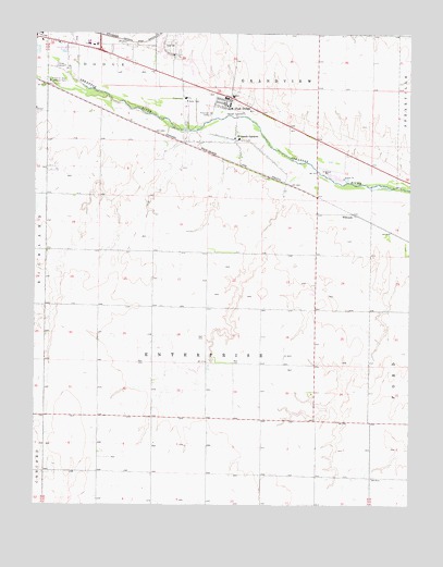
Fort Dodge, KS USGS Topographic Map
Click on map above to begin viewing in our Map Viewer.

This topographic map contains these locations and features:
Feature Name Type Latitude Longitude GNIS ID View Map
D and D Mobile Home ParkPopulated PlaceN37.7238°W99.9081°2694200View Map
Dodge City Pershing Barracks Post HospitalLocaleN37.7323°W99.9370°2625049View Map
Ford CountyCivilN37.6917°W99.8879°484997View Map
Fort DodgePopulated PlaceN37.7320°W99.9354°473892View Map
Fort Dodge (historical)MilitaryN37.7306°W99.9347°485192View Map
Fort Dodge Census Designated PlaceCensusN37.7304°W99.9370°2629156View Map
Fort Dodge ChapelChurchN37.7316°W99.9376°2625037View Map
Fort Dodge Eisenhower HallBuildingN37.7308°W99.9364°2625050View Map
Fort Dodge Halsey HallBuildingN37.7318°W99.9367°2625051View Map
Fort Dodge Kansas State Soldiers HomeBuildingN37.7333°W99.9344°2625338View Map
Fort Dodge LibraryBuildingN37.7311°W99.9375°2625040View Map
Fort Dodge MuseumBuildingN37.7311°W99.9375°2625052View Map
Green Acres Trailer ParkPopulated PlaceN37.7292°W99.9726°2694211View Map
Happy Homes ParkPopulated PlaceN37.7458°W99.9763°2694212View Map
Home for Boys Water TankReservoirN37.7372°W99.9946°473891View Map
Kansas Soldiers Home Wastewater Treatment PlantLocaleN37.7348°W99.9456°2693479View Map
Kansas Veterans' Cemetery at Fort DodgeCemeteryN37.7314°W99.9304°2673261View Map
Las Brisas Mobile Home ParkPopulated PlaceN37.7055°W99.9109°2694218View Map
Ranchwood Mobile EstatesPopulated PlaceN37.7410°W99.9683°2694395View Map
Right Co - Operative Association Grain Elevator Number 8LocaleN37.7018°W99.8940°2695423View Map
Riverview CampLocaleN37.7289°W99.9421°473896View Map
Township of EnterpriseCivilN37.6420°W99.9441°473894View Map
WilroadsPopulated PlaceN37.7017°W99.8937°484659View Map
Wilroads Christian ChurchChurchN37.7222°W99.9340°2689256View Map
Wilroads Feed YardLocaleN37.7128°W99.9569°2743367View Map
Wilroads GardensPopulated PlaceN37.7242°W99.9332°473893View Map
Wilroads Gardens Airport (historical)AirportN37.7228°W99.9262°481456View Map
Wilroads Gardens Census Designated PlaceCensusN37.7153°W99.9268°2629187View Map
Wilroads Gardens Elementary SchoolSchoolN37.7221°W99.9327°2427174View Map
Winter Feed YardLocaleN37.7431°W99.9458°2743371View Map

Note: Coordinates in the location and feature list above are referenced to NAD83 datum.


Copyright (C) 2008-2024 Ryan Niemi / Sunset Dynamics ... All Rights Reserved