TopoQuest Logo
Do you find TopoQuest useful?
Help keep TopoQuest running and adding new maps/features by donating!
Bitcoin:  19c7KJd3qBynnjoSw5npx9KScwjBe4ifkT
Litecoin:  LXs6TkuXGGXo1vDsWCkWVdjQX94eUKd6ui
Home View Maps Find Maps Find Places Resources & Links


Forks, Washington Topographic Map

USGS Map Title: Forks, WA
USGS Map MRC: 47124H4
DRG (GeoTIFF) Download: o47124h4.tif


Neighboring USGS Topographic Map Quads:


  Dickey Lake, WA  
48124A5
 

  Gunderson Mountain, WA  
48124A4
 

  Lake Pleasant, WA  
48124A3
 

  Quillayute Prairie, WA  
47124H5
 

  Forks, WA  
47124H4
 

  Reade Hill, WA  
47124H3
 

  Toleak Point, WA  
47124G5
 

  Hoh Head, WA  
47124G4
 

  Anderson Creek, WA  
47124G3


Map MRC Location:

N48°
W125°
N48°
W124°
H8 H7 H6 H5 H4 H3 H2 H1
G8 G7 G6 G5 G4 G3 G2 G1
F8 F7 F6 F5 F4 F3 F2 F1
E8 E7 E6 E5 E4 E3 E2 E1
D8 D7 D6 D5 D4 D3 D2 D1
C8 C7 C6 C5 C4 C3 C2 C1
B8 B7 B6 B5 B4 B3 B2 B1
A8 A7 A6 A5 A4 A3 A2 A1
N47°
W125°
N47°
W124°

Forks, WA USGS 1:24K Topographic Map Preview:
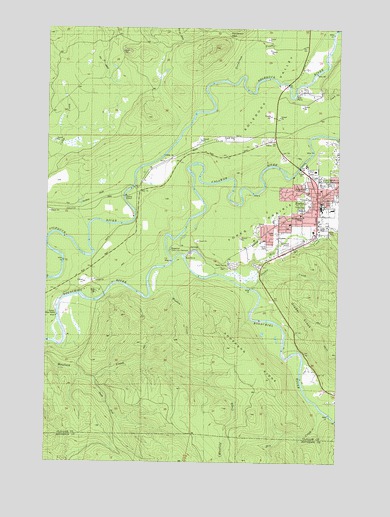
Forks, WA USGS Topographic Map
Click on map above to begin viewing in our Map Viewer.

This topographic map contains these locations and features:
Feature Name Type Latitude Longitude GNIS ID View Map
Anderson RidgeRidgeN47.9017°W124.4130°1515885View Map
Assembly of God ChurchChurchN47.9589°W124.3864°2609494View Map
Calawah RiverStreamN47.9329°W124.4474°1517218View Map
Calawah River BridgeBridgeN47.9598°W124.3931°2607995View Map
Calvary Chapel ForksChurchN47.9463°W124.3914°2608736View Map
Campbell QuarryMineN47.9508°W124.3898°2605669View Map
Church of the NazareneChurchN47.9526°W124.3864°2609495View Map
City of ForksCivilN47.9526°W124.3905°2410520View Map
Congregational ChurchChurchN47.9531°W124.3868°2609496View Map
Department of Natural Resources HeliportAirportN47.9501°W124.3847°1533772View Map
District Run Home SchoolSchoolN47.9469°W124.3860°2518483View Map
Dry CreekStreamN47.8890°W124.3822°1518938View Map
First Baptist ChurchChurchN47.9446°W124.3847°2609497View Map
First Congregational ChurchChurchN47.9482°W124.3847°2609498View Map
ForksPopulated PlaceN47.9504°W124.3855°1519696View Map
Forks AirportAirportN47.9377°W124.3924°1533771View Map
Forks Alternative SchoolSchoolN47.9462°W124.3830°1530627View Map
Forks Ambulance ServiceBuildingN47.9462°W124.3924°2643484View Map
Forks Bible ChurchChurchN47.9436°W124.3975°2609499View Map
Forks City HallBuildingN47.9498°W124.3795°2610612View Map
Forks City Police DepartmentBuildingN47.9498°W124.3796°2722008View Map
Forks Community HospitalHospitalN47.9461°W124.3927°2607644View Map
Forks DamDamN47.9331°W124.4397°1532585View Map
Forks Elementary SchoolSchoolN47.9474°W124.3788°1530399View Map
Forks High SchoolSchoolN47.9484°W124.3838°1530398View Map
Forks High SchoolSchoolN47.9479°W124.3834°1524773View Map
Forks Junior High SchoolSchoolN47.9479°W124.3838°1530401View Map
Forks LibraryBuildingN47.9492°W124.3851°2610148View Map
Forks Middle SchoolSchoolN47.9496°W124.3836°1530400View Map
Forks Mobile Home ParkPopulated PlaceN47.9548°W124.3790°2607247View Map
Forks Post OfficePost OfficeN47.9501°W124.3840°2606950View Map
Forks PrairieFlatN47.9487°W124.3791°1519698View Map
Forks Timber MuseumBuildingN47.9366°W124.3941°2610444View Map
Forks Transit CenterLocaleN47.9452°W124.3849°2605462View Map
Forks Wastewater Treatment PlantLocaleN47.9510°W124.4091°2610762View Map
Fossil CreekStreamN47.9801°W124.3819°1529079View Map
Grader CreekStreamN47.9242°W124.4116°1520181View Map
Grader Creek HillSummitN47.9067°W124.3783°1531813View Map
Gunderson CreekStreamN47.9848°W124.4241°1520412View Map
Gunderson PassGapN47.9981°W124.4222°1528919View Map
Kingdom Hall of Jehovahs WitnessesChurchN47.9428°W124.3813°2609500View Map
KLLM-FM (Forks)TowerN47.9542°W124.3902°1534347View Map
KVAC-AM (Forks)TowerN47.9542°W124.3902°1534254View Map
Marietta Mobile Home CourtPopulated PlaceN47.9490°W124.3807°2607248View Map
Mill CreekStreamN47.9295°W124.4144°1523160View Map
Muralts Mobile Home ParkPopulated PlaceN47.9483°W124.3901°2607249View Map
Old Smokey PitMineN47.9654°W124.4226°2605670View Map
Pacific Ranger District - Forks OfficeBuildingN47.9564°W124.3839°1529517View Map
Prince of Peace Lutheran ChurchChurchN47.9534°W124.3837°2609501View Map
Quillayute Valley School District 402 OfficeSchoolN47.9472°W124.3833°2518462View Map
Rain Forest Mobile Home ParkPopulated PlaceN47.9378°W124.3898°2607250View Map
Ripple CreekStreamN47.9956°W124.3785°1529114View Map
Saint Anne's ChurchChurchN47.9455°W124.3913°2609502View Map
Sol Duc ValleyValleyN47.9581°W124.4513°1526104View Map
South Fork Maxfield CreekStreamN47.8984°W124.4797°1526215View Map
Tassel CreekStreamN47.9817°W124.3947°1526944View Map
Tilicum ParkParkN47.9548°W124.3819°1527217View Map
Wasankaris Mobile Home ParkPopulated PlaceN47.9418°W124.3823°2607251View Map
Weeden CreekStreamN47.9223°W124.4563°1527878View Map
Whitcomb Dimmel PitMineN47.9772°W124.3918°2605672View Map
Willow Place Mobile Home ParkPopulated PlaceN47.9526°W124.3753°2607252View Map
Wilson RanchLocaleN47.9176°W124.4933°1528207View Map
Wilson RanchLocaleN47.9173°W124.4930°1529536View Map

Note: Coordinates in the location and feature list above are referenced to NAD83 datum.


Copyright (C) 2008-2024 Ryan Niemi / Sunset Dynamics ... All Rights Reserved