TopoQuest Logo
Do you find TopoQuest useful?
Help keep TopoQuest running and adding new maps/features by donating!
Bitcoin:  19c7KJd3qBynnjoSw5npx9KScwjBe4ifkT
Litecoin:  LXs6TkuXGGXo1vDsWCkWVdjQX94eUKd6ui
Home View Maps Find Maps Find Places Resources & Links


Floydada, Texas Topographic Map

USGS Map Title: Floydada, TX
USGS Map MRC: 33101H3
DRG (GeoTIFF) Download: o33101h3.tif


Neighboring USGS Topographic Map Quads:


  Lockney, TX  
34101A4
 

  Lockney SE, TX  
34101A3
 

  West of Dick Moore Canyon, TX  
34101A2
 

  Sandhill, TX  
33101H4
 

  Floydada, TX  
33101H3
 

  Boothe, TX  
33101H2
 

  Cone, TX  
33101G4
 

  Floydada SE, TX  
33101G3
 

  Mount Blanco, TX  
33101G2


Map MRC Location:

N34°
W102°
N34°
W101°
H8 H7 H6 H5 H4 H3 H2 H1
G8 G7 G6 G5 G4 G3 G2 G1
F8 F7 F6 F5 F4 F3 F2 F1
E8 E7 E6 E5 E4 E3 E2 E1
D8 D7 D6 D5 D4 D3 D2 D1
C8 C7 C6 C5 C4 C3 C2 C1
B8 B7 B6 B5 B4 B3 B2 B1
A8 A7 A6 A5 A4 A3 A2 A1
N33°
W102°
N33°
W101°

Floydada, TX USGS 1:24K Topographic Map Preview:
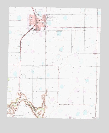
Floydada, TX USGS Topographic Map
Click on map above to begin viewing in our Map Viewer.

This topographic map contains these locations and features:
Feature Name Type Latitude Longitude GNIS ID View Map
A B Duncan Elementary SchoolSchoolN33.9754°W101.3311°2005827View Map
Andrews Ward SchoolSchoolN33.9879°W101.3443°1351123View Map
Annie M Taylor ParkParkN33.9909°W101.3174°2028897View Map
Bethany Baptist Mission ChurchChurchN33.9890°W101.3429°2018918View Map
Bible Baptist ChurchChurchN33.9776°W101.3396°2018919View Map
Cap Rock Learning Co - Op SchoolSchoolN33.9912°W101.3354°2004894View Map
Caprock County Learning Co - opSchoolN33.9845°W101.3374°2005829View Map
Church of Christ - City ParkChurchN33.9809°W101.3365°2018922View Map
City of FloydadaCivilN33.9835°W101.3368°2410514View Map
Della Plain SchoolSchoolN33.9917°W101.3260°1355898View Map
Eagles Hall ParkParkN33.9895°W101.3307°1356552View Map
First Baptist ChurchChurchN33.9820°W101.3485°2018920View Map
Floyd County CourthouseBuildingN33.9856°W101.3354°2030633View Map
Floyd County Historical MuseumBuildingN33.9856°W101.3346°2014151View Map
Floyd County JailBuildingN33.9850°W101.3341°2738821View Map
Floyd County Sheriff's OfficeBuildingN33.9848°W101.3337°2750297View Map
FloydadaPopulated PlaceN33.9845°W101.3377°1357507View Map
Floydada Country ClubLocaleN33.8865°W101.3727°1384563View Map
Floydada DivisionCivilN33.9416°W101.2999°1938744View Map
Floydada Emergency Medical ServicesBuildingN33.9865°W101.3351°2656073View Map
Floydada High SchoolSchoolN33.9792°W101.3470°2005830View Map
Floydada Junior High SchoolSchoolN33.9759°W101.3368°2005831View Map
Floydada Municipal BuildingBuildingN33.9869°W101.3359°2753959View Map
Floydada ParkParkN33.9787°W101.3443°2028359View Map
Floydada Police DepartmentBuildingN33.9869°W101.3360°2750345View Map
Floydada Post OfficePost OfficeN33.9859°W101.3375°2732308View Map
Floydada Volunteer Fire DepartmentBuildingN33.9870°W101.3352°2551894View Map
KKAP-AM (Floydada)TowerN33.9723°W101.3504°1385557View Map
KKAP-FM (Floydada)TowerN33.9687°W101.3540°1385852View Map
LakeviewPopulated PlaceN33.8767°W101.2574°1380051View Map
Mount Zion Baptist ChurchChurchN33.9887°W101.3260°2018921View Map
Napoleon ParkParkN33.9806°W101.3368°1363587View Map
Peoples HospitalHospitalN33.9748°W101.3365°1365051View Map
Plains AssemblyPopulated PlaceN33.8867°W101.3393°1375492View Map
R C Andrews Elementary SchoolSchoolN33.9870°W101.3449°2005835View Map
Ralls Alternative SchoolSchoolN33.9912°W101.3293°2004900View Map

Note: Coordinates in the location and feature list above are referenced to NAD83 datum.


Copyright (C) 2008-2024 Ryan Niemi / Sunset Dynamics ... All Rights Reserved