TopoQuest Logo
Do you find TopoQuest useful?
Help keep TopoQuest running and adding new maps/features by donating!
Bitcoin:  19c7KJd3qBynnjoSw5npx9KScwjBe4ifkT
Litecoin:  LXs6TkuXGGXo1vDsWCkWVdjQX94eUKd6ui
Home View Maps Find Maps Find Places Resources & Links


Flora, Louisiana Topographic Map

USGS Map Title: Flora, LA
USGS Map MRC: 31093E1
DRG (GeoTIFF) Download: o31093e1.tif


Neighboring USGS Topographic Map Quads:


  Provencal, LA  
31093F2
 

  Natchitoches South, LA  
31093F1
 

  Montgomery, LA  
31092F8
 

  Bellwood, LA  
31093E2
 

  Flora, LA  
31093E1
 

  Cloutierville, LA  
31092E8
 

  Kisatchie, LA  
31093D2
 

  Bayou Livrogne, LA  
31093D1
 

  Gorum, LA  
31092D8


Map MRC Location:

N32°
W94°
N32°
W93°
H8 H7 H6 H5 H4 H3 H2 H1
G8 G7 G6 G5 G4 G3 G2 G1
F8 F7 F6 F5 F4 F3 F2 F1
E8 E7 E6 E5 E4 E3 E2 E1
D8 D7 D6 D5 D4 D3 D2 D1
C8 C7 C6 C5 C4 C3 C2 C1
B8 B7 B6 B5 B4 B3 B2 B1
A8 A7 A6 A5 A4 A3 A2 A1
N31°
W94°
N31°
W93°

Flora, LA USGS 1:24K Topographic Map Preview:
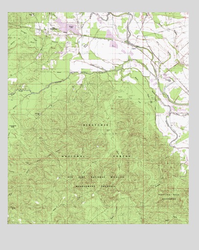
Flora, LA USGS Topographic Map
Click on map above to begin viewing in our Map Viewer.

This topographic map contains these locations and features:
Feature Name Type Latitude Longitude GNIS ID View Map
Antioch ChurchChurchN31.6046°W93.0368°541888View Map
Bayou BlueStreamN31.6113°W93.1238°547007View Map
Bayou DerbonneGutN31.5721°W93.0188°547016View Map
Bayou GorumGutN31.5643°W93.0068°547017View Map
Bayou LuceStreamN31.5907°W93.0502°547021View Map
Bayou Luce LakeSwampN31.5747°W93.0402°558739View Map
Bayou Luce OverlookLocaleN31.5549°W93.0429°559743View Map
Bayou PlatteStreamN31.5910°W93.0468°553509View Map
Bayou ProvencalStreamN31.6068°W93.0766°547023View Map
Bayou Saint JulianGutN31.6179°W93.0732°547026View Map
Bird LakeSwampN31.5728°W93.0242°547090View Map
Blague LakeSwampN31.6154°W93.0840°553707View Map
CypressPopulated PlaceN31.6054°W93.0388°547275View Map
Cypress Post OfficePost OfficeN31.6149°W93.0341°1631259View Map
Dowen CemeteryCemeteryN31.5357°W93.1107°547307View Map
Dry BayouGutN31.6049°W93.0191°547312View Map
FloraPopulated PlaceN31.6124°W93.0977°547366View Map
Flora Post OfficePost OfficeN31.6122°W93.0979°1631260View Map
Flora School (historical)SchoolN31.6127°W93.0904°549511View Map
Good Hope ChurchChurchN31.5649°W93.1027°547404View Map
Good Hope School (historical)SchoolN31.5654°W93.1024°549512View Map
Horseshoe LakeLakeN31.5812°W93.0161°554779View Map
Kisatchie BayouStreamN31.5852°W93.0213°554938View Map
Laird BranchStreamN31.5493°W93.1238°547559View Map
McKims CreekStreamN31.6077°W93.1166°547671View Map
Melrose OverlookLocaleN31.5507°W93.0260°559744View Map
Parish Governing Authority District 10CivilN31.5379°W93.1179°1929786View Map
Pentecost ChurchChurchN31.6246°W93.0546°549571View Map
Pole BranchStreamN31.5457°W93.0507°547861View Map
Provencal LakeSwampN31.6110°W93.1173°547873View Map
Red Dirt (historical)Populated PlaceN31.5074°W93.0354°549574View Map
Russell CemeteryCemeteryN31.5552°W93.0568°547919View Map
Russell School (historical)SchoolN31.5407°W93.0110°549576View Map
Saint Marys ChurchChurchN31.5624°W93.0129°547935View Map
Sand CreekStreamN31.5899°W93.0571°547954View Map
Sand CreekStreamN31.6160°W93.0860°547956View Map
Ward FourCivilN31.5557°W93.0168°545141View Map
Weaver CemeteryCemeteryN31.6235°W93.1079°548129View Map

Note: Coordinates in the location and feature list above are referenced to NAD83 datum.


Copyright (C) 2008-2024 Ryan Niemi / Sunset Dynamics ... All Rights Reserved