TopoQuest Logo
Do you find TopoQuest useful?
Help keep TopoQuest running and adding new maps/features by donating!
Bitcoin:  19c7KJd3qBynnjoSw5npx9KScwjBe4ifkT
Litecoin:  LXs6TkuXGGXo1vDsWCkWVdjQX94eUKd6ui
Home View Maps Find Maps Find Places Resources & Links


Flener, Kentucky Topographic Map

USGS Map Title: Flener, KY
USGS Map MRC: 37086C6
DRG (GeoTIFF) Download: o37086c6.tif


Neighboring USGS Topographic Map Quads:


  Horton, KY  
37086D7
 

  Rosine, KY  
37086D6
 

  Spring Lick, KY  
37086D5
 

  Cromwell, KY  
37086C7
 

  Flener, KY  
37086C6
 

  Welchs Creek, KY  
37086C5
 

  South Hill, KY  
37086B7
 

  Morgantown, KY  
37086B6
 

  Riverside, KY  
37086B5


Map MRC Location:

N38°
W87°
N38°
W86°
H8 H7 H6 H5 H4 H3 H2 H1
G8 G7 G6 G5 G4 G3 G2 G1
F8 F7 F6 F5 F4 F3 F2 F1
E8 E7 E6 E5 E4 E3 E2 E1
D8 D7 D6 D5 D4 D3 D2 D1
C8 C7 C6 C5 C4 C3 C2 C1
B8 B7 B6 B5 B4 B3 B2 B1
A8 A7 A6 A5 A4 A3 A2 A1
N37°
W87°
N37°
W86°

Flener, KY USGS 1:24K Topographic Map Preview:
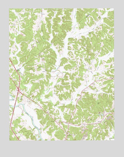
Flener, KY USGS Topographic Map
Click on map above to begin viewing in our Map Viewer.

This topographic map contains these locations and features:
Feature Name Type Latitude Longitude GNIS ID View Map
AberdeenPopulated PlaceN37.2539°W86.6817°485727View Map
BaizetownPopulated PlaceN37.3706°W86.7108°507436View Map
BanockPopulated PlaceN37.3509°W86.6555°507450View Map
Belmont ChurchChurchN37.2670°W86.6375°486833View Map
Cowhorn HollowValleyN37.3192°W86.6924°490203View Map
Cromwell Fire DepartmentBuildingN37.2965°W86.7343°2636469View Map
DextervillePopulated PlaceN37.3175°W86.6561°507852View Map
East Prong Indian Camp CreekStreamN37.2900°W86.7139°491498View Map
EdenPopulated PlaceN37.2756°W86.7044°507907View Map
Fifth District SchoolSchoolN37.3087°W86.6267°492071View Map
Fifth District Volunteer Fire Department Station 2BuildingN37.3168°W86.7087°2637350View Map
FlenerPopulated PlaceN37.2895°W86.6667°508011View Map
Flener ChapelChurchN37.2973°W86.6614°492238View Map
Flint SpringsPopulated PlaceN37.3434°W86.7136°508015View Map
Fourth District Volunteer Fire Department Main StationBuildingN37.2659°W86.6909°2637359View Map
GilstrapPopulated PlaceN37.3153°W86.7067°508089View Map
Green River Boys CampLocaleN37.2900°W86.7358°493286View Map
Haunted HollowValleyN37.2588°W86.6261°493872View Map
Holston HollowValleyN37.3168°W86.7319°494436View Map
Indian Camp CreekStreamN37.2842°W86.7330°494914View Map
Lindsey CreekStreamN37.2828°W86.6936°496574View Map
Mauldon BranchStreamN37.3114°W86.6497°497688View Map
McKendree ChapelChurchN37.2850°W86.6450°497894View Map
MonfordPopulated PlaceN37.2673°W86.6414°508623View Map
Mount Liberty ChurchChurchN37.3667°W86.6433°498769View Map
Mount Vernon ChurchChurchN37.3267°W86.6566°498892View Map
Mount Zion ChurchChurchN37.3706°W86.7108°498932View Map
North Prong Indian Camp CreekStreamN37.3473°W86.6789°499584View Map
Rattlesnake HollowValleyN37.2933°W86.6320°2742347View Map
SelectPopulated PlaceN37.3598°W86.7450°509029View Map
Sixes CreekStreamN37.3412°W86.7000°503585View Map
Stillhouse HollowValleyN37.3731°W86.6262°504421View Map
Walnut Grove ChurchChurchN37.2678°W86.6964°506174View Map
Welchs Creek DivisionCivilN37.3170°W86.6256°1937312View Map
WelcomePopulated PlaceN37.3037°W86.6514°509335View Map
West Prong Indian Camp CreekStreamN37.2914°W86.7300°506472View Map
Wild BranchStreamN37.3270°W86.6894°506722View Map
Wolfpen HollowValleyN37.2984°W86.6595°507068View Map

Note: Coordinates in the location and feature list above are referenced to NAD83 datum.


Copyright (C) 2008-2024 Ryan Niemi / Sunset Dynamics ... All Rights Reserved