TopoQuest Logo
Do you find TopoQuest useful?
Help keep TopoQuest running and adding new maps/features by donating!
Bitcoin:  19c7KJd3qBynnjoSw5npx9KScwjBe4ifkT
Litecoin:  LXs6TkuXGGXo1vDsWCkWVdjQX94eUKd6ui
Home View Maps Find Maps Find Places Resources & Links


Five Points, New Jersey Topographic Map

USGS Map Title: Five Points, NJ
USGS Map MRC: 39074D8
DRG (GeoTIFF) Download: o39074d8.tif


Neighboring USGS Topographic Map Quads:


  Newfield, NJ  
39075E1
 

  Buena, NJ  
39074E8
 

  Newtonville, NJ  
39074E7
 

  Millville, NJ  
39075D1
 

  Five Points, NJ  
39074D8
 

  Dorothy, NJ  
39074D7
 

  Dividing Creek, NJ  
39075C1
 

  Port Elizabeth, NJ  
39074C8
 

  Tuckahoe, NJ  
39074C7


Map MRC Location:

N40°
W75°
N40°
W74°
H8 H7 H6 H5 H4 H3 H2 H1
G8 G7 G6 G5 G4 G3 G2 G1
F8 F7 F6 F5 F4 F3 F2 F1
E8 E7 E6 E5 E4 E3 E2 E1
D8 D7 D6 D5 D4 D3 D2 D1
C8 C7 C6 C5 C4 C3 C2 C1
B8 B7 B6 B5 B4 B3 B2 B1
A8 A7 A6 A5 A4 A3 A2 A1
N39°
W75°
N39°
W74°

Five Points, NJ USGS 1:24K Topographic Map Preview:
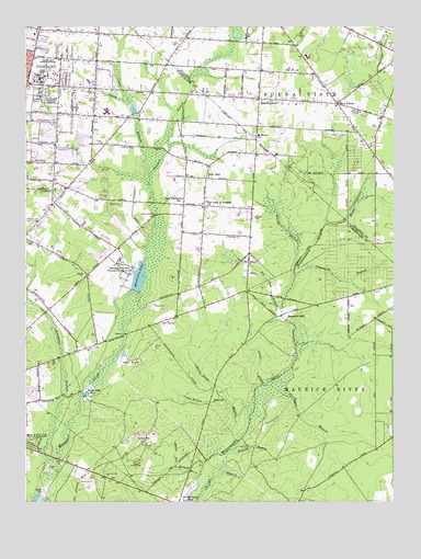
Five Points, NJ USGS Topographic Map
Click on map above to begin viewing in our Map Viewer.

This topographic map contains these locations and features:
Feature Name Type Latitude Longitude GNIS ID View Map
Anthony Rossi Intermediate SchoolSchoolN39.4481°W74.9796°2333363View Map
Bear BranchStreamN39.4797°W74.9649°874583View Map
Bears Head BranchStreamN39.3900°W74.9290°874606View Map
Bennetts MillPopulated PlaceN39.4246°W74.9113°874673View Map
Berryman BranchStreamN39.3858°W74.9928°874700View Map
Big Neal BranchStreamN39.4225°W74.9116°874757View Map
Buena Vista Township Emergency Medical ServicesBuildingN39.4807°W74.9224°2659978View Map
Canute BranchStreamN39.4056°W74.9197°875185View Map
Cedar BranchStreamN39.4056°W74.9186°875254View Map
Cedar BranchStreamN39.4606°W74.9577°875257View Map
Chincopin BranchStreamN39.3762°W74.9417°875418View Map
City of VinelandCivilN39.4653°W74.9981°885428View Map
Cossa Boones BranchStreamN39.4014°W74.9322°875662View Map
East VinelandPopulated PlaceN39.4809°W74.9193°876071View Map
East Vineland SchoolSchoolN39.4551°W74.9454°876072View Map
East Vineland Volunteer Fire DepartmentBuildingN39.4807°W74.9226°2401858View Map
Emmanuel Day SchoolSchoolN39.4974°W74.9541°2333402View Map
Five PointsPopulated PlaceN39.4798°W74.8935°876364View Map
Free Spirit Airport (historical)AirportN39.4423°W74.9421°884965View Map
Hances BridgeBridgeN39.4504°W74.9549°876923View Map
Holly Heights Elementary SchoolSchoolN39.3854°W74.9956°2333195View Map
Ingersall BranchStreamN39.4343°W74.9085°877339View Map
J L Gentile HeliportAirportN39.4843°W74.8813°884686View Map
Leamings MillPopulated PlaceN39.4029°W74.9793°877716View Map
Little Acres Learning Center SchoolSchoolN39.4845°W74.9814°2333358View Map
Memorial Park PondReservoirN39.4785°W74.9637°883961View Map
Memorial Park Pond DamDamN39.4768°W74.9630°883960View Map
Menantico ColonySchoolN39.4373°W74.9680°878061View Map
Menantico DamDamN39.4301°W74.9630°883959View Map
Menantico LakeReservoirN39.4329°W74.9620°878063View Map
Nash Education Center PreschoolSchoolN39.4838°W74.9949°2333415View Map
New ItalyPopulated PlaceN39.4598°W74.9368°878741View Map
Newcombs NurseryBuildingN39.4969°W74.9611°2634358View Map
Oak and Main School Kindergarten CenterSchoolN39.4997°W74.9956°2333409View Map
Our Lady of Pompeii ChurchChurchN39.4534°W74.9396°879039View Map
Panther BranchStreamN39.4606°W74.9577°879108View Map
Petway Elementary SchoolSchoolN39.4677°W74.9745°2333414View Map
Saint Mary's Regional SchoolSchoolN39.4715°W74.9210°2333296View Map
Saint Marys ChurchChurchN39.4715°W74.9207°880106View Map
Sharps BranchStreamN39.4378°W74.9073°880511View Map
Simone's Apple FarmLocaleN39.4992°W74.9531°2516168View Map
Sweeten WaterStreamN39.3885°W74.9304°881056View Map
The Ellison SchoolSchoolN39.4697°W74.9890°2333319View Map
Vineland Fire Department Station 4BuildingN39.4999°W74.9965°2401895View Map
Vineland Fire Department Station 5BuildingN39.4608°W74.9446°2401896View Map
Vineland High School NorthSchoolN39.4807°W74.9707°2333269View Map
Vineland High School SouthSchoolN39.4775°W74.9725°883415View Map
Vineland State SchoolSchoolN39.4904°W74.9924°881467View Map
Vineland Training SchoolSchoolN39.4815°W74.9910°881468View Map
White Oak BranchStreamN39.3823°W74.9415°881788View Map

Note: Coordinates in the location and feature list above are referenced to NAD83 datum.


Copyright (C) 2008-2024 Ryan Niemi / Sunset Dynamics ... All Rights Reserved