TopoQuest Logo
Do you find TopoQuest useful?
Help keep TopoQuest running and adding new maps/features by donating!
Bitcoin:  19c7KJd3qBynnjoSw5npx9KScwjBe4ifkT
Litecoin:  LXs6TkuXGGXo1vDsWCkWVdjQX94eUKd6ui
Home View Maps Find Maps Find Places Resources & Links


Fife Peak, Arizona Topographic Map

USGS Map Title: Fife Peak, AZ
USGS Map MRC: 31109H4
DRG (GeoTIFF) Download: o31109h4.tif


Neighboring USGS Topographic Map Quads:


  Pat Hills North, AZ  
32109A5
 

  Bowie Mountain South, AZ  
32109A4
 

  Cochise Head, AZ  
32109A3
 

  Pat Hills South, AZ  
31109H5
 

  Fife Peak, AZ  
31109H4
 

  Rustler Park, AZ  
31109H3
 

  Squaretop Hills East, AZ  
31109G5
 

  Stanford Canyon, AZ  
31109G4
 

  Chiricahua Peak, AZ  
31109G3


Map MRC Location:

N32°
W110°
N32°
W109°
H8 H7 H6 H5 H4 H3 H2 H1
G8 G7 G6 G5 G4 G3 G2 G1
F8 F7 F6 F5 F4 F3 F2 F1
E8 E7 E6 E5 E4 E3 E2 E1
D8 D7 D6 D5 D4 D3 D2 D1
C8 C7 C6 C5 C4 C3 C2 C1
B8 B7 B6 B5 B4 B3 B2 B1
A8 A7 A6 A5 A4 A3 A2 A1
N31°
W110°
N31°
W109°

Fife Peak, AZ USGS 1:24K Topographic Map Preview:
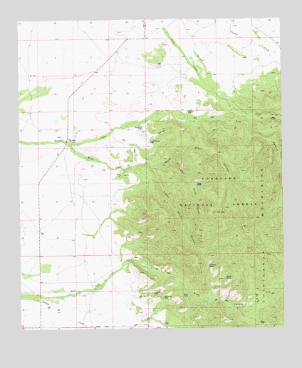
Fife Peak, AZ USGS Topographic Map
Click on map above to begin viewing in our Map Viewer.

This topographic map contains these locations and features:
Feature Name Type Latitude Longitude GNIS ID View Map
Baldridge TankReservoirN31.8859°W109.3891°21921View Map
Bates TankReservoirN31.8768°W109.3877°1077View Map
Boundary TankReservoirN31.9567°W109.4417°1882View Map
Bumblebee TankReservoirN31.8876°W109.4328°2193View Map
Chiricahua MountainsRangeN31.9298°W109.3823°2876View Map
Concrete TankReservoirN31.8895°W109.4375°3163View Map
Crescent TankReservoirN31.9632°W109.4204°3568View Map
Fife CanyonValleyN31.9637°W109.4309°4585View Map
Fife Canyon Trail Two Hundred FiftyeightTrailN31.9329°W109.4006°22045View Map
Fife PeakSummitN31.9218°W109.4070°4586View Map
Madrono SpringSpringN31.9002°W109.4111°7583View Map
Middle Witch CanyonValleyN31.9431°W109.4284°8023View Map
North Witch CanyonValleyN31.9393°W109.4378°8806View Map
Oak RanchLocaleN31.9518°W109.4740°8872View Map
Pine CanyonValleyN31.9654°W109.4020°9452View Map
Ratliff SpringSpringN31.8955°W109.4032°9964View Map
Riggs TankReservoirN31.9331°W109.4164°10272View Map
Rock CanyonValleyN31.9012°W109.4509°10381View Map
Rock CreekStreamN31.8887°W109.4995°10392View Map
Rock TankReservoirN31.8885°W109.4211°10426View Map
Roll RanchLocaleN31.9751°W109.4878°22201View Map
South Witch CanyonValleyN31.9393°W109.4378°11651View Map
Trunk CanyonValleyN31.9495°W109.4437°12740View Map
Trunk Canyon TankReservoirN31.9505°W109.4390°12741View Map
Witch Canyon Trail Two Hundred SixtyTrailN31.9081°W109.4173°22299View Map
Witch CreekStreamN31.9509°W109.4778°13947View Map

Note: Coordinates in the location and feature list above are referenced to NAD83 datum.


Copyright (C) 2008-2024 Ryan Niemi / Sunset Dynamics ... All Rights Reserved