TopoQuest Logo
Do you find TopoQuest useful?
Help keep TopoQuest running and adding new maps/features by donating!
Bitcoin:  19c7KJd3qBynnjoSw5npx9KScwjBe4ifkT
Litecoin:  LXs6TkuXGGXo1vDsWCkWVdjQX94eUKd6ui
Home View Maps Find Maps Find Places Resources & Links


Festus, Missouri Topographic Map

USGS Map Title: Festus, MO
USGS Map MRC: 38090B4
DRG (GeoTIFF) Download: o38090b4.tif


Neighboring USGS Topographic Map Quads:


  Belews Creek, MO  
38090C5
 

  Herculaneum, MO  
38090C4
 

  Valmeyer, IL  
38090C3
 

  De Soto, MO  
38090B5
 

  Festus, MO  
38090B4
 

  Selma, MO  
38090B3
 

  Vineland, MO  
38090A5
 

  Halifax, MO  
38090A4
 

  Danby, MO  
38090A3


Map MRC Location:

N39°
W91°
N39°
W90°
H8 H7 H6 H5 H4 H3 H2 H1
G8 G7 G6 G5 G4 G3 G2 G1
F8 F7 F6 F5 F4 F3 F2 F1
E8 E7 E6 E5 E4 E3 E2 E1
D8 D7 D6 D5 D4 D3 D2 D1
C8 C7 C6 C5 C4 C3 C2 C1
B8 B7 B6 B5 B4 B3 B2 B1
A8 A7 A6 A5 A4 A3 A2 A1
N38°
W91°
N38°
W90°

Festus, MO USGS 1:24K Topographic Map Preview:
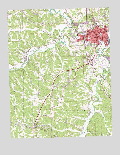
Festus, MO USGS Topographic Map
Click on map above to begin viewing in our Map Viewer.

This topographic map contains these locations and features:
Feature Name Type Latitude Longitude GNIS ID View Map
BaileyPopulated PlaceN38.2251°W90.4315°738302View Map
Bailey School (historical)SchoolN38.2206°W90.4237°737731View Map
Baker CemeteryCemeteryN38.2465°W90.4283°713112View Map
Buck CreekStreamN38.2131°W90.4426°714955View Map
City of Crystal CityCivilN38.2221°W90.3808°2393684View Map
City of FestusCivilN38.2199°W90.4096°2394763View Map
City of Olympian VillageCivilN38.1347°W90.4584°2396063View Map
Crystal CityPopulated PlaceN38.2212°W90.3790°736291View Map
Crystal City Police DepartmentBuildingN38.2210°W90.3774°2752477View Map
Crystal City Post OfficePost OfficeN38.2175°W90.3820°2779545View Map
Crystal City Volunteer Fire DepartmentBuildingN38.2209°W90.3781°2621242View Map
DonnellPopulated PlaceN38.2137°W90.4590°738303View Map
Dry CreekStreamN38.2288°W90.4986°717092View Map
Fairview ChurchChurchN38.1645°W90.3796°717783View Map
FestusPopulated PlaceN38.2206°W90.3960°736296View Map
Festus Crystal City Sewage Treatment PlantLocaleN38.2101°W90.3834°2469029View Map
Festus Fire DepartmentBuildingN38.2215°W90.3929°2467958View Map
Festus Memorial AirportAirportN38.1950°W90.3864°758680View Map
Festus Police DepartmentBuildingN38.2193°W90.3992°2752249View Map
Festus Post OfficePost OfficeN38.2203°W90.3964°2782780View Map
Festus Senior High SchoolSchoolN38.2238°W90.4141°2469371View Map
Flucom CreekStreamN38.1251°W90.4157°718043View Map
Gamel CemeteryCemeteryN38.2158°W90.4009°2702341View Map
Hardys LakeLakeN38.1280°W90.4122°719091View Map
Harrison LakeReservoirN38.2164°W90.4321°719162View Map
HematitePopulated PlaceN38.2020°W90.4810°736304View Map
Hematite Fire Protection DistrictBuildingN38.2039°W90.4860°2620995View Map
Hematite Fire Protection District Station 2BuildingN38.1846°W90.4579°2467983View Map
Hematite Post OfficePost OfficeN38.2032°W90.4785°2783011View Map
Hocum HollowValleyN38.1501°W90.3954°719658View Map
Jefferson Memorial Hospital HeliportAirportN38.1959°W90.3935°758652View Map
KJCF-AM (Festus)TowerN38.2323°W90.3973°759244View Map
Lake Trails DamDamN38.2451°W90.4651°764218View Map
Lake VirginiaReservoirN38.2084°W90.4818°758358View Map
Lake Virginia DamDamN38.2084°W90.4818°764215View Map
Little CreekStreamN38.2279°W90.4372°721204View Map
LudwigPopulated PlaceN38.2351°W90.4190°741030View Map
Madison CemeteryCemeteryN38.1836°W90.3930°721746View Map
MapavillePopulated PlaceN38.2489°W90.4835°721814View Map
Mapaville Fire Protection DistrictBuildingN38.2462°W90.4901°2620918View Map
Mapaville Post OfficePost OfficeN38.2485°W90.4848°2783091View Map
McClain CemeteryCemeteryN38.1267°W90.3800°722040View Map
McCormack CemeteryCemeteryN38.1264°W90.4073°722056View Map
McCormack School (historical)SchoolN38.1312°W90.4129°737732View Map
McNutt SchoolSchoolN38.2434°W90.3996°742599View Map
Mercy Hospital JeffersonHospitalN38.1972°W90.3935°720276View Map
Mount Zion CemeteryCemeteryN38.2014°W90.4079°722931View Map
Ogles Lake DamDamN38.2401°W90.4485°765172View Map
Old Plattin ChurchChurchN38.1298°W90.4037°723773View Map
Old Town CemeteryCemeteryN38.2150°W90.3807°723794View Map
Olympian VillagePopulated PlaceN38.1362°W90.4579°738373View Map
Our Lady SchoolSchoolN38.2267°W90.4187°723896View Map
PlattinPopulated PlaceN38.1312°W90.4115°724470View Map
Pleasant Valley SchoolSchoolN38.1639°W90.4368°742601View Map
Randall SchoolSchoolN38.2037°W90.3985°742600View Map
Roselawn CemeteryCemeteryN38.2312°W90.3857°725573View Map
Sacred Heart CemeteryCemeteryN38.2325°W90.3868°725703View Map
Sacred Heart SchoolSchoolN38.2209°W90.3890°725706View Map
Saint Pius X High SchoolSchoolN38.2014°W90.3929°725900View Map
SilicaPopulated PlaceN38.2348°W90.4260°736349View Map
Sunny Side Church (historical)ChurchN38.1531°W90.4648°737735View Map
Sunnyside CemeteryCemeteryN38.1534°W90.4654°713116View Map
Sunset ParkParkN38.2206°W90.4001°727333View Map
Telegraph ChurchChurchN38.1692°W90.3843°727521View Map
Telegraph SchoolSchoolN38.1692°W90.3843°742078View Map
Township of River ViewCivilN38.2215°W90.3964°2397861View Map
Wildwood Lake DamDamN38.1267°W90.4435°764216View Map
Willers LakeReservoirN38.2078°W90.3901°728873View Map
Williams DamDamN38.2151°W90.4701°764150View Map
Williams LakeReservoirN38.2160°W90.4715°764151View Map
Zion SchoolSchoolN38.2487°W90.4840°742598View Map
Zion United Methodist Church CemeteryCemeteryN38.2492°W90.4813°2702381View Map

Note: Coordinates in the location and feature list above are referenced to NAD83 datum.


Copyright (C) 2008-2024 Ryan Niemi / Sunset Dynamics ... All Rights Reserved