TopoQuest Logo
Do you find TopoQuest useful?
Help keep TopoQuest running and adding new maps/features by donating!
Bitcoin:  19c7KJd3qBynnjoSw5npx9KScwjBe4ifkT
Litecoin:  LXs6TkuXGGXo1vDsWCkWVdjQX94eUKd6ui
Home View Maps Find Maps Find Places Resources & Links


Felderville, South Carolina Topographic Map

USGS Map Title: Felderville, SC
USGS Map MRC: 33080D5
DRG (GeoTIFF) Download: o33080d5.tif


Neighboring USGS Topographic Map Quads:


  Cameron, SC  
33080E6
 

  Elloree, SC  
33080E5
 

  Saint Paul, SC  
33080E4
 

  Indian Camp Branch, SC  
33080D6
 

  Felderville, SC  
33080D5
 

  Vance, SC  
33080D4
 

  Bowman, SC  
33080C6
 

  Wadboo Swamp, SC  
33080C5
 

  Holly Hill, SC  
33080C4


Map MRC Location:

N34°
W81°
N34°
W80°
H8 H7 H6 H5 H4 H3 H2 H1
G8 G7 G6 G5 G4 G3 G2 G1
F8 F7 F6 F5 F4 F3 F2 F1
E8 E7 E6 E5 E4 E3 E2 E1
D8 D7 D6 D5 D4 D3 D2 D1
C8 C7 C6 C5 C4 C3 C2 C1
B8 B7 B6 B5 B4 B3 B2 B1
A8 A7 A6 A5 A4 A3 A2 A1
N33°
W81°
N33°
W80°

Felderville, SC USGS 1:24K Topographic Map Preview:
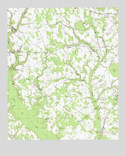
Felderville, SC USGS Topographic Map
Click on map above to begin viewing in our Map Viewer.

This topographic map contains these locations and features:
Feature Name Type Latitude Longitude GNIS ID View Map
Antioch CemeteryCemeteryN33.4602°W80.5256°1242508View Map
Antioch ChurchChurchN33.4604°W80.5251°1220214View Map
Ball BranchStreamN33.4321°W80.5456°1242493View Map
Ball BranchStreamN33.4313°W80.5351°1242512View Map
Bochette CemeteryCemeteryN33.4593°W80.6123°1220846View Map
Bulls Pond Dam D-3774DamN33.4418°W80.5481°1240352View Map
Bush BranchStreamN33.4021°W80.5956°1247072View Map
Candy BranchStreamN33.4277°W80.5329°1221301View Map
Canty BranchStreamN33.4282°W80.5345°1242492View Map
Center School (historical)SchoolN33.3774°W80.6187°1247232View Map
DantzlerPopulated PlaceN33.4196°W80.5040°1242594View Map
Dantzler Middle SchoolSchoolN33.4160°W80.5004°1251812View Map
Elloree DivisionCivilN33.4617°W80.5659°1938260View Map
FeldervillePopulated PlaceN33.4635°W80.5437°1247732View Map
Felderville ChurchChurchN33.4413°W80.6148°1242616View Map
Felderville SchoolSchoolN33.4410°W80.6126°1222368View Map
Ferris SchoolSchoolN33.3757°W80.6104°1222378View Map
Goodbys School (historical)SchoolN33.4696°W80.6065°1245770View Map
Goodbys SwampStreamN33.4415°W80.6198°1245771View Map
Granger ChurchChurchN33.4913°W80.6034°1242641View Map
Granger School (historical)SchoolN33.4915°W80.6009°1245810View Map
Greater Friendship African Methodist Episcopal ChurchChurchN33.4482°W80.5144°1222572View Map
Gresham CemeteryCemeteryN33.4907°W80.6029°1242644View Map
Hickory Grove ChurchChurchN33.4977°W80.6084°1223133View Map
Interchange 90CrossingN33.3827°W80.5187°1228312View Map
Ireland School (historical)SchoolN33.4213°W80.5865°1242668View Map
Island CemeteriesCemeteryN33.4260°W80.5723°1242669View Map
Island SchoolSchoolN33.4277°W80.5665°1223468View Map
Jack BranchStreamN33.4096°W80.5262°1242670View Map
Keller BranchStreamN33.4774°W80.6201°1241280View Map
Lewis Shuler Family CemeteryCemeteryN33.3846°W80.5430°1242850View Map
Martin CemeteryCemeteryN33.4131°W80.5013°1242689View Map
McGrew CemeteryCemeteryN33.4860°W80.6027°2681220View Map
Mill BranchStreamN33.4113°W80.6223°1246656View Map
Mount Olive ChurchChurchN33.3977°W80.5506°1242714View Map
Mount Olive SchoolSchoolN33.3974°W80.5498°1224755View Map
Murcheys Landing CemeteryCemeteryN33.3902°W80.5842°2681226View Map
North Providence SchoolSchoolN33.4204°W80.5543°1225088View Map
Oak Grove Baptist ChurchChurchN33.4583°W80.5304°1225102View Map
Oak Grove Baptist Church CemeteryCemeteryN33.4586°W80.5296°2681231View Map
Oak Grove School (historical)SchoolN33.4596°W80.5301°1242738View Map
Oaks CrossroadsPopulated PlaceN33.4585°W80.6245°1242742View Map
ParlerPopulated PlaceN33.4935°W80.5104°1231635View Map
ProvidencePopulated PlaceN33.3927°W80.5420°1242788View Map
Providence CemeteryCemeteryN33.3929°W80.5401°1242789View Map
Providence CemeteryCemeteryN33.4357°W80.5193°1242790View Map
Providence ChurchChurchN33.4304°W80.5198°1242791View Map
Providence ChurchChurchN33.3927°W80.5404°1242792View Map
Providence Fire DepartmentBuildingN33.3934°W80.5423°2368478View Map
Providence Fire Department Station 2BuildingN33.4571°W80.5947°2368110View Map
Providence SchoolSchoolN33.3918°W80.5390°1225701View Map
Providence SchoolSchoolN33.4299°W80.5187°1225702View Map
Red Hill Baptist ChurchChurchN33.4322°W80.6019°2490198View Map
Saluda ChurchChurchN33.4757°W80.5595°1242834View Map
South Carolina Noname 38030 D-3761 DamDamN33.4652°W80.5448°1238130View Map
White Cane BranchStreamN33.4468°W80.5220°1242892View Map

Note: Coordinates in the location and feature list above are referenced to NAD83 datum.


Copyright (C) 2008-2024 Ryan Niemi / Sunset Dynamics ... All Rights Reserved