TopoQuest Logo
Do you find TopoQuest useful?
Help keep TopoQuest running and adding new maps/features by donating!
Bitcoin:  19c7KJd3qBynnjoSw5npx9KScwjBe4ifkT
Litecoin:  LXs6TkuXGGXo1vDsWCkWVdjQX94eUKd6ui
Home View Maps Find Maps Find Places Resources & Links


Fancy Gap, Virginia Topographic Map

USGS Map Title: Fancy Gap, VA
USGS Map MRC: 36080F6
DRG (GeoTIFF) Download: o36080f6.tif


Neighboring USGS Topographic Map Quads:


  Sylvatus, VA  
36080G7
 

  Hillsville, VA  
36080G6
 

  Dugspur, VA  
36080G5
 

  Woodlawn, VA  
36080F7
 

  Fancy Gap, VA  
36080F6
 

  Laurel Fork, VA  
36080F5
 

  Lambsburg, VA  
36080E7
 

  Cana, VA  
36080E6
 

  Mount Airy North, NC  
36080E5


Map MRC Location:

N37°
W81°
N37°
W80°
H8 H7 H6 H5 H4 H3 H2 H1
G8 G7 G6 G5 G4 G3 G2 G1
F8 F7 F6 F5 F4 F3 F2 F1
E8 E7 E6 E5 E4 E3 E2 E1
D8 D7 D6 D5 D4 D3 D2 D1
C8 C7 C6 C5 C4 C3 C2 C1
B8 B7 B6 B5 B4 B3 B2 B1
A8 A7 A6 A5 A4 A3 A2 A1
N36°
W81°
N36°
W80°

Fancy Gap, VA USGS 1:24K Topographic Map Preview:
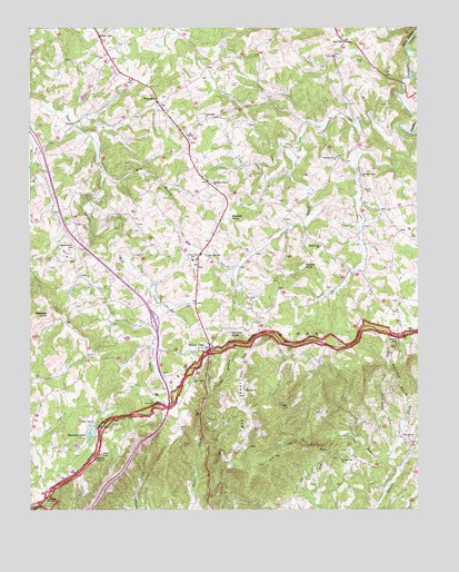
Fancy Gap, VA USGS Topographic Map
Click on map above to begin viewing in our Map Viewer.

This topographic map contains these locations and features:
Feature Name Type Latitude Longitude GNIS ID View Map
Alexander Webb CemeteryCemeteryN36.7054°W80.6698°1738582View Map
Ayers CemeteryCemeteryN36.6504°W80.6562°1738591View Map
Banks CemeteryCemeteryN36.7079°W80.6398°1462766View Map
Beamer KnobSummitN36.6757°W80.7442°1495242View Map
Blue Ridge ParkwayParkN36.6721°W80.6426°1462298View Map
Bobbitt KnobSummitN36.7010°W80.6856°1495281View Map
Carroll CountyCivilN36.7316°W80.7339°1480108View Map
Charles H Webb CemeteryCemeteryN36.7457°W80.7184°1738629View Map
Crooked Oak CemeteryCemeteryN36.6385°W80.6506°1738649View Map
Crooked Oak ChurchChurchN36.6379°W80.6501°1465466View Map
Dell Turner CemeteryCemeteryN36.6848°W80.6706°1738662View Map
Doctor Jess Dickens CemeteryCemeteryN36.6793°W80.6334°1738666View Map
East Fork Little Reed Island CreekStreamN36.7326°W80.7495°1466103View Map
Elk SpurRidgeN36.6518°W80.6817°1466227View Map
Elk Spur BranchStreamN36.6387°W80.6351°1466228View Map
Elk Spur CemeteryCemeteryN36.6582°W80.6806°1738677View Map
Elk Spur ChurchChurchN36.6560°W80.6809°1466229View Map
Elk Spur School (historical)SchoolN36.6562°W80.6809°1738678View Map
Fancy GapPopulated PlaceN36.6660°W80.6923°1495531View Map
Fancy Gap Census Designated PlaceCensusN36.6770°W80.6997°2389075View Map
Fancy Gap ChurchChurchN36.6587°W80.6976°1466479View Map
Fancy Gap Elementary schoolSchoolN36.6899°W80.6979°1466480View Map
Fancy Gap Post OfficePost OfficeN36.6700°W80.6934°2766362View Map
Fielden Worrell CemeteryCemeteryN36.7273°W80.7153°1738687View Map
Guynn CemeteryCemeteryN36.6443°W80.6478°1738713View Map
Hall CemeteryCemeteryN36.7068°W80.6606°1738714View Map
Hardy-Jenkins CemeteryCemeteryN36.7323°W80.6737°1738715View Map
Harris MountainSummitN36.6451°W80.7020°1738716View Map
Heath Banks CemeteryCemeteryN36.6971°W80.6548°1738718View Map
Henley CemeteryCemeteryN36.7260°W80.6781°1738720View Map
Hill CemeteryCemeteryN36.6873°W80.7223°1738723View Map
Horton CemeteryCemeteryN36.7157°W80.7184°1738728View Map
Horton CemeteryCemeteryN36.7301°W80.6348°1738729View Map
Horton CemeteryCemeteryN36.6985°W80.6403°1738730View Map
Independence CemeteryCemeteryN36.6932°W80.7356°1468450View Map
Independence School (historical)SchoolN36.6926°W80.7353°1738732View Map
Interchange 8CrossingN36.6743°W80.7098°1738734View Map
Jack Allen CemeteryCemeteryN36.6804°W80.6984°1738738View Map
Jesse Bond CemeteryCemeteryN36.6829°W80.6528°1738746View Map
Johnson-Leftwich CemeteryCemeteryN36.6329°W80.7387°1738755View Map
Joseph Horton CemeteryCemeteryN36.7398°W80.6545°1738760View Map
Lewis F Webb CemeteryCemeteryN36.7471°W80.6731°1738771View Map
Little Snake CreekStreamN36.7254°W80.6251°1469653View Map
Macey BranchStreamN36.7168°W80.6267°1469983View Map
McCraw CemeteryCemeteryN36.6879°W80.7437°1738800View Map
McMillian CemeteryCemeteryN36.6990°W80.7153°1738804View Map
Melton CemeteryCemeteryN36.6771°W80.6787°1738808View Map
Milepost 197 CemeteryCemeteryN36.6676°W80.6506°1738810View Map
Mine BranchStreamN36.7118°W80.7265°1470591View Map
Mitchell KnobSummitN36.6696°W80.6851°1470641View Map
Morris CemeteryCemeteryN36.6462°W80.7017°1470756View Map
Mountain Plains CemeteryCemeteryN36.7104°W80.6915°1738826View Map
Mountain Plains ChurchChurchN36.7099°W80.6915°1471175View Map
Nelson CemeteryCemeteryN36.6973°W80.7145°1738829View Map
Oak Grove CemeteryCemeteryN36.6435°W80.6287°1738840View Map
Oak Grove ChurchChurchN36.6432°W80.6281°1471702View Map
Old Fellowship ChurchChurchN36.7118°W80.6431°1471841View Map
Patch Incorporated DamDamN36.6735°W80.7165°1489404View Map
Piedmont OverlookLocaleN36.6274°W80.7453°1472280View Map
Pleasant Grove Baptist ChurchChurchN36.7162°W80.6512°1472471View Map
Pleasant Grove CemeteryCemeteryN36.7165°W80.6512°1738863View Map
Quesenberry-Semones CemeteryCemeteryN36.7371°W80.6945°1738868View Map
Red HillPopulated PlaceN36.7462°W80.6487°1477666View Map
Rigney CemeteryCemeteryN36.6373°W80.6859°1738872View Map
Round KnobSummitN36.6882°W80.6617°1496173View Map
Round Knob ChurchChurchN36.6932°W80.6565°1473582View Map
Sarah Payne CemeteryCemeteryN36.6257°W80.7478°1738885View Map
Semones CemeteryCemeteryN36.7323°W80.7059°1738887View Map
Semones-Sunnyside CemeteryCemeteryN36.7260°W80.6928°1738888View Map
Sky View ChurchChurchN36.6912°W80.6931°1474658View Map
Skyland LakesLocaleN36.6460°W80.7276°1474659View Map
Skyview-Webb CemeteryCemeteryN36.6915°W80.6923°1738901View Map
Snake CreekStreamN36.7446°W80.6284°1474797View Map
Stockner CemeteryCemeteryN36.6412°W80.7431°1738909View Map
Sugarloaf OverlookLocaleN36.6382°W80.7295°1475299View Map
SunnysidePopulated PlaceN36.7301°W80.7081°1477794View Map
Sunnyside ChurchChurchN36.7265°W80.6931°1475337View Map
Sunnyside School (historical)SchoolN36.7312°W80.7084°1738913View Map
Thomas CemeteryCemeteryN36.6315°W80.6598°1738923View Map
Vinson CemeteryCemeteryN36.7354°W80.6848°1738940View Map
Wards GapGapN36.6679°W80.6323°1476317View Map
Wash Edwards CemeteryCemeteryN36.6507°W80.6778°1738943View Map
Waterfall BranchStreamN36.6526°W80.6284°1476368View Map
Webb CemeteryCemeteryN36.7415°W80.6451°1738945View Map
Webb CemeteryCemeteryN36.7246°W80.6578°1738946View Map
West DamDamN36.6435°W80.7315°1489405View Map
Wilson CemeteryCemeteryN36.6912°W80.7417°1738961View Map
Yankee BranchStreamN36.6551°W80.6926°1474322View Map

Note: Coordinates in the location and feature list above are referenced to NAD83 datum.


Copyright (C) 2008-2024 Ryan Niemi / Sunset Dynamics ... All Rights Reserved