TopoQuest Logo
Do you find TopoQuest useful?
Help keep TopoQuest running and adding new maps/features by donating!
Bitcoin:  19c7KJd3qBynnjoSw5npx9KScwjBe4ifkT
Litecoin:  LXs6TkuXGGXo1vDsWCkWVdjQX94eUKd6ui
Home View Maps Find Maps Find Places Resources & Links


Falun, Kansas Topographic Map

USGS Map Title: Falun, KS
USGS Map MRC: 38097F7
DRG (GeoTIFF) Download: o38097f7.tif


Neighboring USGS Topographic Map Quads:


  Brookville SW, KS  
38097G8
 

  Brookville, KS  
38097G7
 

  Salina SW, KS  
38097G6
 

  Venango, KS  
38097F8
 

  Falun, KS  
38097F7
 

  Smolan, KS  
38097F6
 

  Langley, KS  
38097E8
 

  Marquette, KS  
38097E7
 

  Lindsborg, KS  
38097E6


Map MRC Location:

N39°
W98°
N39°
W97°
H8 H7 H6 H5 H4 H3 H2 H1
G8 G7 G6 G5 G4 G3 G2 G1
F8 F7 F6 F5 F4 F3 F2 F1
E8 E7 E6 E5 E4 E3 E2 E1
D8 D7 D6 D5 D4 D3 D2 D1
C8 C7 C6 C5 C4 C3 C2 C1
B8 B7 B6 B5 B4 B3 B2 B1
A8 A7 A6 A5 A4 A3 A2 A1
N38°
W98°
N38°
W97°

Falun, KS USGS 1:24K Topographic Map Preview:
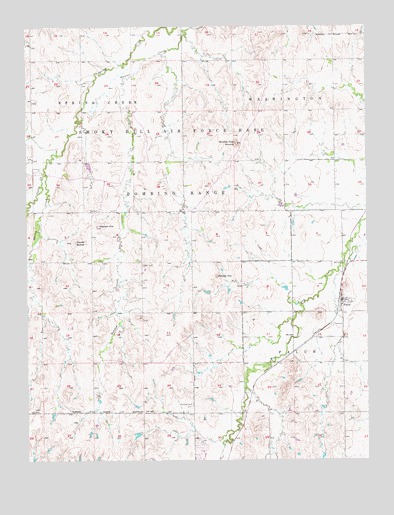
Falun, KS USGS Topographic Map
Click on map above to begin viewing in our Map Viewer.

This topographic map contains these locations and features:
Feature Name Type Latitude Longitude GNIS ID View Map
Castle CreekStreamN38.7075°W97.8681°476941View Map
Coiner DomeSummitN38.6878°W97.8573°476939View Map
Dry Creek (historical)LocaleN38.6436°W97.7948°485155View Map
Dry Creek CemeteryCemeteryN38.6408°W97.8150°476936View Map
FalunPopulated PlaceN38.6711°W97.7595°476938View Map
Falun Census Designated PlaceCensusN38.6744°W97.7511°2583499View Map
Falun Lutheran ChurchChurchN38.6713°W97.7577°2690006View Map
Falun Post OfficePost OfficeN38.6698°W97.7596°2693717View Map
Falun Wastewater PlantLocaleN38.6740°W97.7638°2693438View Map
Potato HillSummitN38.6781°W97.8056°476937View Map
Smoky Hill RangeMilitaryN38.7038°W97.8130°2512018View Map
Soldier Cap MoundSummitN38.7161°W97.7953°476942View Map
Team Marketing Alliance Grain Elevator Number 12LocaleN38.6725°W97.7601°2695385View Map
Township of FalunCivilN38.6531°W97.8142°476943View Map
Township of WashingtonCivilN38.7402°W97.7618°476788View Map
Weston HillSummitN38.6925°W97.8495°476940View Map

Note: Coordinates in the location and feature list above are referenced to NAD83 datum.


Copyright (C) 2008-2024 Ryan Niemi / Sunset Dynamics ... All Rights Reserved