TopoQuest Logo
Do you find TopoQuest useful?
Help keep TopoQuest running and adding new maps/features by donating!
Bitcoin:  19c7KJd3qBynnjoSw5npx9KScwjBe4ifkT
Litecoin:  LXs6TkuXGGXo1vDsWCkWVdjQX94eUKd6ui
Home View Maps Find Maps Find Places Resources & Links


Fairview, South Dakota Topographic Map

USGS Map Title: Fairview, SD
USGS Map MRC: 43096B4
DRG (GeoTIFF) Download: o43096b4.tif


Neighboring USGS Topographic Map Quads:


  Canton, SD  
43096C5
 

  Inwood, IA  
43096C4
 

  Alvord, IA  
43096C3
 

  Alcester NE, SD  
43096B5
 

  Fairview, SD  
43096B4
 

  Rock Valley, IA  
43096B3
 

  Alcester SE, SD  
43096A5
 

  Hawarden North, IA  
43096A4
 

  Lebanon, IA  
43096A3


Map MRC Location:

N44°
W97°
N44°
W96°
H8 H7 H6 H5 H4 H3 H2 H1
G8 G7 G6 G5 G4 G3 G2 G1
F8 F7 F6 F5 F4 F3 F2 F1
E8 E7 E6 E5 E4 E3 E2 E1
D8 D7 D6 D5 D4 D3 D2 D1
C8 C7 C6 C5 C4 C3 C2 C1
B8 B7 B6 B5 B4 B3 B2 B1
A8 A7 A6 A5 A4 A3 A2 A1
N43°
W97°
N43°
W96°

Fairview, SD USGS 1:24K Topographic Map Preview:
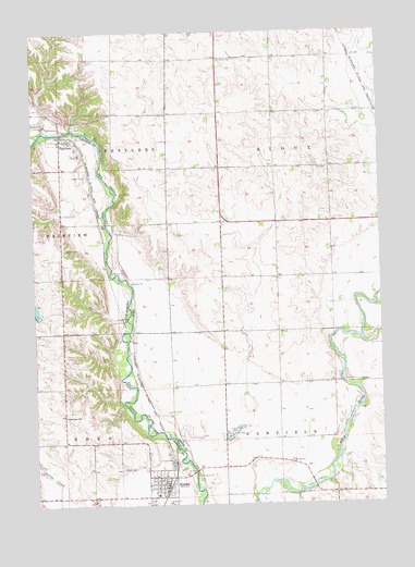
Fairview, SD USGS Topographic Map
Click on map above to begin viewing in our Map Viewer.

This topographic map contains these locations and features:
Feature Name Type Latitude Longitude GNIS ID View Map
Big Sioux Public Hunting AreaAreaN43.2025°W96.4684°464361View Map
Big Sioux River Wildlife AreaParkN43.2014°W96.4711°1906359View Map
Blanchard SchoolSchoolN43.1486°W96.4898°1253960View Map
Darlington Post Office (historical)Post OfficeN43.2255°W96.4975°1906361View Map
Driesen Hog FarmLocaleN43.1736°W96.4111°2712636View Map
Eden CemeteryCemeteryN43.1343°W96.4695°1254879View Map
Elmsprings (historical)LocaleN43.2255°W96.4975°1906363View Map
Elmsprings Post Office (historical)Post OfficeN43.2255°W96.4975°1906362View Map
FairviewPopulated PlaceN43.2216°W96.4900°1254984View Map
Fairview (historical)LocaleN43.2125°W96.4881°1263283View Map
Fairview AreaParkN43.2333°W96.4809°1906357View Map
Fairview CemeteryCemeteryN43.1927°W96.4896°1254985View Map
Fairview Fire DepartmentBuildingN43.2218°W96.4883°2580742View Map
Fairview Post OfficePost OfficeN43.2218°W96.4886°2709878View Map
Farmers Post Office (historical)Post OfficeN43.2433°W96.4703°466433View Map
HudsonPopulated PlaceN43.1303°W96.4542°1265658View Map
Hudson Ambulance AssociationBuildingN43.1289°W96.4545°2659017View Map
Hudson Fire DepartmentBuildingN43.1292°W96.4545°2580914View Map
Hudson Post OfficePost OfficeN43.1302°W96.4538°2710044View Map
Hudson Public LibraryBuildingN43.1302°W96.4536°2723590View Map
J and L FarmLocaleN43.1558°W96.3911°2712609View Map
Kaskie FarmLocaleN43.2022°W96.4342°2712605View Map
Settlers Canoe AccessLocaleN43.2278°W96.4809°1906358View Map
Sioux CemeteryCemeteryN43.2426°W96.4321°461651View Map
Sioux TownhallBuildingN43.2139°W96.3939°463367View Map
Stonebarn FarmsLocaleN43.2125°W96.4442°2712603View Map
Town of FairviewCivilN43.2220°W96.4874°1267387View Map
Town of HudsonCivilN43.1301°W96.4556°1267430View Map
Township of GarfieldCivilN43.1283°W96.3936°467900View Map
Township of SettlersCivilN43.2322°W96.4967°468680View Map
Township of SiouxCivilN43.2143°W96.3928°468719View Map
Van Grootheest FarmsLocaleN43.2128°W96.3789°2712630View Map
Vonk FarmsLocaleN43.1528°W96.3933°2712602View Map
Ysselstein DairyLocaleN43.2186°W96.4392°2650388View Map

Note: Coordinates in the location and feature list above are referenced to NAD83 datum.


Copyright (C) 2008-2024 Ryan Niemi / Sunset Dynamics ... All Rights Reserved