TopoQuest Logo
Do you find TopoQuest useful?
Help keep TopoQuest running and adding new maps/features by donating!
Bitcoin:  19c7KJd3qBynnjoSw5npx9KScwjBe4ifkT
Litecoin:  LXs6TkuXGGXo1vDsWCkWVdjQX94eUKd6ui
Home View Maps Find Maps Find Places Resources & Links


Excell, Tennessee Topographic Map

USGS Map Title: Excell, TN
USGS Map MRC: 36087D3
DRG (GeoTIFF) Download: o36087d3.tif


Neighboring USGS Topographic Map Quads:


  New Providence, TN  
36087E4
 

  Clarksville, TN  
36087E3
 

  Sango, TN  
36087E2
 

  Palmyra, TN  
36087D4
 

  Excell, TN  
36087D3
 

  Henrietta, TN  
36087D2
 

  Slayden, TN  
36087C4
 

  Cumberland Furnace, TN  
36087C3
 

  Cheatham Dam, TN  
36087C2


Map MRC Location:

N37°
W88°
N37°
W87°
H8 H7 H6 H5 H4 H3 H2 H1
G8 G7 G6 G5 G4 G3 G2 G1
F8 F7 F6 F5 F4 F3 F2 F1
E8 E7 E6 E5 E4 E3 E2 E1
D8 D7 D6 D5 D4 D3 D2 D1
C8 C7 C6 C5 C4 C3 C2 C1
B8 B7 B6 B5 B4 B3 B2 B1
A8 A7 A6 A5 A4 A3 A2 A1
N36°
W88°
N36°
W87°

Excell, TN USGS 1:24K Topographic Map Preview:
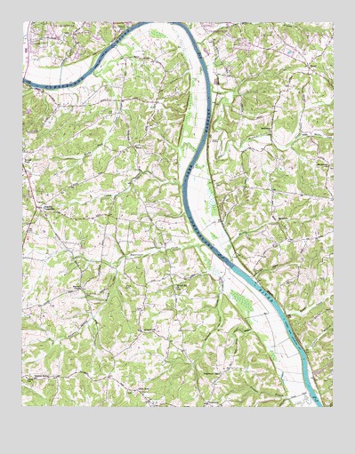
Excell, TN USGS Topographic Map
Click on map above to begin viewing in our Map Viewer.

This topographic map contains these locations and features:
Feature Name Type Latitude Longitude GNIS ID View Map
Bethlehem ChurchChurchN36.4645°W87.2753°1305178View Map
Bethlehem School (historical)SchoolN36.4756°W87.2695°1319586View Map
Big McAdoo CreekStreamN36.4800°W87.2995°1305219View Map
Brame CemeteryCemeteryN36.4131°W87.3336°1278223View Map
Brush CreekStreamN36.4051°W87.2689°1278682View Map
Burtons LandingLocaleN36.3912°W87.2608°1645001View Map
Cabin RowLocaleN36.3792°W87.3258°1279270View Map
Cabin Row Missionary Baptist ChurchChurchN36.3803°W87.3322°1319594View Map
Camp CreekStreamN36.4470°W87.3103°1305623View Map
Chapel Hill ChurchChurchN36.4137°W87.3128°1305855View Map
Clarksville Boat ClubLocaleN36.4925°W87.3397°1319603View Map
Clarksville Fire Rescue Station 4BuildingN36.4992°W87.3382°2654093View Map
Commissioner District 4CivilN36.3991°W87.3349°2464070View Map
Cotton BarBarN36.4376°W87.3083°1311480View Map
Coxs BarBarN36.4509°W87.3089°1645003View Map
Cumberland HillsPopulated PlaceN36.4981°W87.3606°1311484View Map
Davidson CemeteryCemeteryN36.4159°W87.2692°1282101View Map
Davidsons LandingLocaleN36.4173°W87.2833°1645004View Map
Davis RippleRapidsN36.4028°W87.2697°1645005View Map
Dawson CreekStreamN36.4276°W87.3039°1282214View Map
DeerfieldPopulated PlaceN36.4912°W87.2683°1311488View Map
District 15 (historical)CivilN36.4667°W87.2625°1325939View Map
District 16 (historical)CivilN36.3764°W87.2917°1325940View Map
District 17 (historical)CivilN36.4501°W87.3500°1325941View Map
Dixon SchoolSchoolN36.3845°W87.3725°1306353View Map
Edmondsons Ferry (historical)CrossingN36.4789°W87.3603°1645006View Map
ExcellPopulated PlaceN36.4862°W87.2600°1315032View Map
Excell Baptist ChurchChurchN36.4928°W87.2533°1319626View Map
Forest AcresPopulated PlaceN36.4848°W87.2917°1311493View Map
Frazier BranchStreamN36.3787°W87.2586°1284851View Map
GlenstonePopulated PlaceN36.4945°W87.2797°1311499View Map
Grantville (historical)Populated PlaceN36.4548°W87.2520°1311500View Map
Gratton Station (historical)LocaleN36.4828°W87.2970°1319640View Map
Greenland FarmsPopulated PlaceN36.4881°W87.3706°1311503View Map
Hagewood ChapelChurchN36.3859°W87.2947°1286489View Map
Harmon School (historical)SchoolN36.4537°W87.2511°1319646View Map
Harris LandingLocaleN36.3831°W87.2614°1645008View Map
Hickory Point School (historical)SchoolN36.4331°W87.2692°1319651View Map
Hollingsworth LandingLocaleN36.4214°W87.2931°1645010View Map
Hurricane CreekStreamN36.4284°W87.3014°1288817View Map
KingsburyPopulated PlaceN36.4945°W87.3456°1311516View Map
Lakeside EstatesPopulated PlaceN36.4900°W87.3533°1311518View Map
Lime Kiln LandingLocaleN36.4639°W87.3006°1645012View Map
Little McAdoo CreekStreamN36.4634°W87.2639°1291563View Map
LiverworthPopulated PlaceN36.4003°W87.3264°1291732View Map
Lock BDamN36.4206°W87.2920°1291753View Map
Lyle CemeteryCemeteryN36.4706°W87.3386°1292324View Map
Marthas ChapelChurchN36.4131°W87.3508°1292788View Map
Medallion AcresPopulated PlaceN36.4931°W87.2875°1311526View Map
Midnight HollowValleyN36.4168°W87.2825°1293717View Map
Mount Herman Christian Methodist Episcopal ChurchChurchN36.4539°W87.2514°1294633View Map
Muddy BranchStreamN36.4226°W87.2914°1295030View Map
Neblets LandingLocaleN36.4384°W87.3095°1645016View Map
Old Lock and Dam B (historical)DamN36.4203°W87.2903°1319687View Map
Orgains CrossroadsPopulated PlaceN36.4389°W87.3692°1315656View Map
Rock BarsBarN36.4823°W87.3503°1645022View Map
Rocky Ford CreekStreamN36.4842°W87.3461°1299885View Map
Rotary HillsPopulated PlaceN36.4959°W87.2695°1311549View Map
Round Pond School (historical)SchoolN36.4578°W87.3742°1319702View Map
SalemPopulated PlaceN36.4598°W87.3303°1315866View Map
Salem Field Airport (historical)AirportN36.4791°W87.3494°2675492View Map
Salem School (historical)SchoolN36.4598°W87.3303°1319708View Map
Salem United Methodist ChurchChurchN36.4589°W87.3300°1319709View Map
Seven Mile Ferry (historical)CrossingN36.4925°W87.3386°1645026View Map
Seven Mile IslandIslandN36.4878°W87.3458°1645027View Map
Sheltons LandingLocaleN36.3926°W87.2636°1645028View Map
Southern ViewPopulated PlaceN36.4917°W87.3708°1311558View Map
Southside Post OfficePost OfficeN36.3770°W87.3003°1651293View Map
Southside School (historical)SchoolN36.3759°W87.2950°1319716View Map
Stewart CemeteryCemeteryN36.4172°W87.2529°1271367View Map
Sulphur BranchStreamN36.3923°W87.2611°1271771View Map
Sulphur Spring BranchStreamN36.4220°W87.3358°1271810View Map
Sulphur Spring ChurchChurchN36.3842°W87.3692°1303923View Map
Taylors LandingLocaleN36.3934°W87.2614°1645029View Map
Tin Cup HollowValleyN36.4123°W87.2945°1272662View Map
Titan FieldAirportN36.4895°W87.3315°2675493View Map
Wall BranchStreamN36.4934°W87.3050°1304343View Map
Washington Furnace (historical)LocaleN36.4045°W87.3472°1326880View Map
Whiskey BarBarN36.4898°W87.3042°1645031View Map
Wilsons LandingLocaleN36.4273°W87.2986°1645032View Map
Woodridge EstatesPopulated PlaceN36.4953°W87.2595°1311577View Map

Note: Coordinates in the location and feature list above are referenced to NAD83 datum.


Copyright (C) 2008-2024 Ryan Niemi / Sunset Dynamics ... All Rights Reserved