TopoQuest Logo
Do you find TopoQuest useful?
Help keep TopoQuest running and adding new maps/features by donating!
Bitcoin:  19c7KJd3qBynnjoSw5npx9KScwjBe4ifkT
Litecoin:  LXs6TkuXGGXo1vDsWCkWVdjQX94eUKd6ui
Home View Maps Find Maps Find Places Resources & Links


Eutaw, Alabama Topographic Map

USGS Map Title: Eutaw, AL
USGS Map MRC: 32087G8
DRG (GeoTIFF) Download: o32087g8.tif


Neighboring USGS Topographic Map Quads:


  West Greene, AL  
32088H1
 

  Union, AL  
32087H8
 

  Knoxville, AL  
32087H7
 

  Boligee, AL  
32088G1
 

  Eutaw, AL  
32087G8
 

  Warrior Dam, AL  
32087G7
 

  Epes East, AL  
32088F1
 

  Forkland, AL  
32087F8
 

  Mason Bend, AL  
32087F7


Map MRC Location:

N33°
W88°
N33°
W87°
H8 H7 H6 H5 H4 H3 H2 H1
G8 G7 G6 G5 G4 G3 G2 G1
F8 F7 F6 F5 F4 F3 F2 F1
E8 E7 E6 E5 E4 E3 E2 E1
D8 D7 D6 D5 D4 D3 D2 D1
C8 C7 C6 C5 C4 C3 C2 C1
B8 B7 B6 B5 B4 B3 B2 B1
A8 A7 A6 A5 A4 A3 A2 A1
N32°
W88°
N32°
W87°

Eutaw, AL USGS 1:24K Topographic Map Preview:
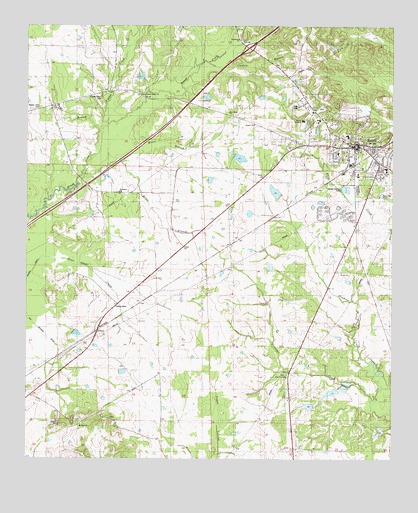
Eutaw, AL USGS Topographic Map
Click on map above to begin viewing in our Map Viewer.

This topographic map contains these locations and features:
Feature Name Type Latitude Longitude GNIS ID View Map
AllisonPopulated PlaceN32.7868°W87.9758°155987View Map
Banks LakeReservoirN32.8384°W87.9301°131043View Map
Bankston SchoolSchoolN32.8476°W87.9283°132451View Map
Bean Stack CreekStreamN32.8076°W87.9956°113632View Map
Bermul (historical)LocaleN32.8051°W87.9431°132461View Map
Bethlehem CemeteryCemeteryN32.8717°W87.9267°158624View Map
Bethlehem Primitive Baptist ChurchChurchN32.8712°W87.9281°157891View Map
Beulah CemeteryCemeteryN32.8043°W87.8922°158627View Map
Beulah ChurchChurchN32.8040°W87.8925°114185View Map
Boligee Hill Plantation (historical)LocaleN32.7599°W87.9889°132475View Map
Bovell BranchStreamN32.8451°W87.9756°114766View Map
Clanton BranchStreamN32.8643°W87.9392°116165View Map
Cook School (historical)SchoolN32.8257°W87.9653°132510View Map
Cooks Chapel Number 2 ChurchChurchN32.8271°W87.9689°132512View Map
Culpeper CreekStreamN32.7660°W87.8753°116950View Map
Dance BranchStreamN32.8315°W87.9814°132522View Map
Daniels PrairieAreaN32.7543°W87.9125°132523View Map
Danoe BranchStreamN32.8349°W87.9722°132524View Map
Doc Hollingsworth LakeReservoirN32.7653°W87.9035°131014View Map
Doctor Hollingsworth DamDamN32.7668°W87.9033°131013View Map
Elizabeth School (historical)SchoolN32.7960°W87.8817°132536View Map
EutawPopulated PlaceN32.8407°W87.8875°118059View Map
Eutaw ChurchChurchN32.8415°W87.8897°132542View Map
Eutaw Female College (historical)SchoolN32.8412°W87.8895°137012View Map
Eutaw Middle SchoolSchoolN32.8337°W87.8772°132543View Map
Eutaw Police DepartmentBuildingN32.8412°W87.8867°2751879View Map
Eutaw Post OfficePost OfficeN32.8396°W87.8877°2789106View Map
Eutaw Volunteer Fire DepartmentBuildingN32.8411°W87.8900°2691286View Map
Exit 40CrossingN32.8687°W87.9245°155710View Map
Ezekiel ChurchChurchN32.8465°W87.9231°118094View Map
First Baptist ChurchChurchN32.8360°W87.8806°158340View Map
First Christian ChurchChurchN32.8410°W87.8889°137013View Map
First Methodist Episcopal Church (historical)ChurchN32.8404°W87.8903°137014View Map
Green Oak School (historical)SchoolN32.7637°W87.9478°132564View Map
Greene CountyCivilN32.8531°W87.9522°161557View Map
Greene County Area Vocational CenterSchoolN32.8479°W87.9000°143006View Map
Greene County CourthouseBuildingN32.8404°W87.8875°154917View Map
Greene County Courthouse Square Historic DistrictParkN32.8404°W87.8872°158341View Map
Greene County HospitalHospitalN32.8431°W87.8902°2669269View Map
Greene County Sheriff's OfficeBuildingN32.8406°W87.8875°2752060View Map
Hardy Lake Number 1ReservoirN32.7691°W87.8957°131016View Map
Hatfield Seminary (historical)SchoolN32.8549°W87.9050°132570View Map
Hays MountSummitN32.7615°W87.9745°132571View Map
Hays Plantation (historical)LocaleN32.7615°W87.9745°132572View Map
Jerusalem Baptist ChurchChurchN32.8271°W87.9689°157993View Map
Jerusalem Church (historical)ChurchN32.8143°W87.9625°132596View Map
Jordan Artesian WellWellN32.8532°W87.8814°154071View Map
KirkwoodBuildingN32.8465°W87.8958°158342View Map
L C Hardy DamsDamN32.7685°W87.8967°131015View Map
Lower Gainesville Road Volunteer Fire DepartmentBuildingN32.8516°W87.9913°2691378View Map
Mesopotamia (historical)LocaleN32.8515°W87.9028°166006View Map
Mesopotamia CemeteryCemeteryN32.8511°W87.9000°132641View Map
Mesopotamia Post Office (historical)Post OfficeN32.8515°W87.9028°169287View Map
Miles CollegeSchoolN32.8432°W87.8903°132644View Map
Miller BranchStreamN32.8321°W87.9814°122816View Map
Moore BranchStreamN32.8357°W87.9684°122985View Map
Mount Zoar Baptist ChurchChurchN32.7596°W87.9814°158037View Map
Mount Zoar CemeteryCemeteryN32.7603°W87.9809°158644View Map
Mount Zoar School (historical)SchoolN32.7599°W87.9800°132655View Map
New Christian Baptist ChurchChurchN32.8268°W87.8825°158120View Map
New Hope Church (historical)ChurchN32.8224°W87.9297°132659View Map
New Hope Primitive Baptist ChurchChurchN32.8501°W87.9320°123822View Map
Odum Lake Number 1ReservoirN32.8272°W87.9151°131039View Map
Peter J Kirksey Area Vocational CenterSchoolN32.8460°W87.9189°158414View Map
Pippen CreekStreamN32.8465°W87.9725°152953View Map
Pippen Lawn CemeteryCemeteryN32.8516°W87.9958°158903View Map
Pippen Place CemeteryCemeteryN32.8549°W87.9748°152954View Map
R R Banks Lake DamDamN32.8385°W87.9317°131044View Map
Ragans Christian Methodist Episcopal Chapel (historical)ChurchN32.8421°W87.8850°150880View Map
Rising Star Church (historical)ChurchN32.7826°W87.9442°132687View Map
Saint Stephens ChurchChurchN32.8421°W87.8922°154073View Map
Second Baptist ChurchChurchN32.8412°W87.8847°137018View Map
Taylor LakeReservoirN32.7573°W87.8798°131000View Map
Temperence School (historical)SchoolN32.8093°W87.9736°132722View Map
The PrairieAreaN32.7918°W87.8958°132681View Map
Town of EutawCivilN32.8436°W87.8986°2406470View Map
W A Taylor Camp DamDamN32.7585°W87.8783°131001View Map
W R Odum DamDamN32.8251°W87.9150°131038View Map
Warrior AcademySchoolN32.8479°W87.9061°128595View Map
Zion Brush Creek ChurchChurchN32.8554°W87.9614°154058View Map
Zion ChurchChurchN32.7740°W87.9097°132756View Map
Zion Friendship Baptist ChurchChurchN32.7743°W87.9108°158965View Map
Zion Friendship CemeteryCemeteryN32.7743°W87.9114°158661View Map

Note: Coordinates in the location and feature list above are referenced to NAD83 datum.


Copyright (C) 2008-2024 Ryan Niemi / Sunset Dynamics ... All Rights Reserved