TopoQuest Logo
Do you find TopoQuest useful?
Help keep TopoQuest running and adding new maps/features by donating!
Bitcoin:  19c7KJd3qBynnjoSw5npx9KScwjBe4ifkT
Litecoin:  LXs6TkuXGGXo1vDsWCkWVdjQX94eUKd6ui
Home View Maps Find Maps Find Places Resources & Links


Ethel South, Mississippi Topographic Map

USGS Map Title: Ethel South, MS
USGS Map MRC: 33089A4
DRG (GeoTIFF) Download: o33089a4.tif


Neighboring USGS Topographic Map Quads:


  Kosciusko NE, MS  
33089B5
 

  Ethel North, MS  
33089B4
 

  McCool, MS  
33089B3
 

  Kosciusko, MS  
33089A5
 

  Ethel South, MS  
33089A4
 

  Ethel SE, MS  
33089A3
 

  Singleton, MS  
32089H5
 

  Zama, MS  
32089H4
 

  Four Corners, MS  
32089H3


Map MRC Location:

N34°
W90°
N34°
W89°
H8 H7 H6 H5 H4 H3 H2 H1
G8 G7 G6 G5 G4 G3 G2 G1
F8 F7 F6 F5 F4 F3 F2 F1
E8 E7 E6 E5 E4 E3 E2 E1
D8 D7 D6 D5 D4 D3 D2 D1
C8 C7 C6 C5 C4 C3 C2 C1
B8 B7 B6 B5 B4 B3 B2 B1
A8 A7 A6 A5 A4 A3 A2 A1
N33°
W90°
N33°
W89°

Ethel South, MS USGS 1:24K Topographic Map Preview:
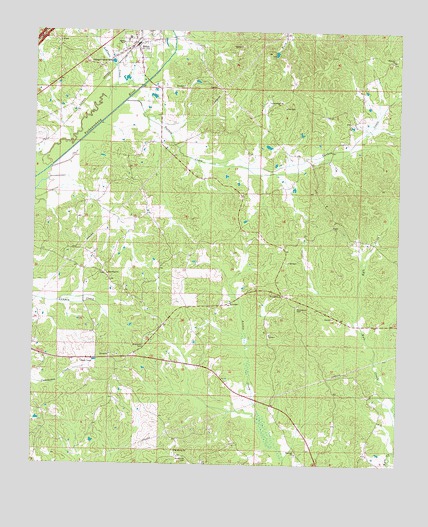
Ethel South, MS USGS Topographic Map
Click on map above to begin viewing in our Map Viewer.

This topographic map contains these locations and features:
Feature Name Type Latitude Longitude GNIS ID View Map
Breazeale CemeteryCemeteryN33.0340°W89.4620°690908View Map
Carson Ridge (historical)Populated PlaceN33.1043°W89.4320°710853View Map
Carson Ridge Baptist ChurchChurchN33.1051°W89.4156°668103View Map
Carson Ridge CemeteryCemeteryN33.1051°W89.4162°691049View Map
Carson Ridge School (historical)SchoolN33.1043°W89.4329°710854View Map
Cowpen (historical)Populated PlaceN33.0418°W89.4798°690015View Map
Eagle Mills (historical)LocaleN33.0154°W89.4967°690017View Map
Ebenezer Baptist ChurchChurchN33.0032°W89.4084°669650View Map
Ebenezer CemeteryCemeteryN33.0029°W89.4090°710874View Map
Edgefield School (historical)SchoolN33.0010°W89.4070°710878View Map
EthelPopulated PlaceN33.1204°W89.4659°669815View Map
Ethel Baptist ChurchChurchN33.1237°W89.4662°690018View Map
Ethel High SchoolSchoolN33.1232°W89.4681°710879View Map
Ethel Post OfficePost OfficeN33.1208°W89.4657°2768863View Map
Harmony Baptist ChurchChurchN33.1168°W89.3781°670938View Map
Harmony CemeteryCemeteryN33.1162°W89.3781°710892View Map
Joplin (historical)Populated PlaceN33.0312°W89.4654°710901View Map
Joplin School (historical)SchoolN33.0318°W89.4681°710903View Map
Joplins Mill (historical)LocaleN33.0312°W89.4262°710902View Map
Mercer (historical)Populated PlaceN33.0446°W89.4509°690026View Map
Mississippi No Name 5 DamDamN33.0935°W89.4217°681842View Map
Mount Moriah CemeteryCemeteryN33.0023°W89.4476°674056View Map
Mount Moriah ChurchChurchN33.0040°W89.4509°674068View Map
New Hope (historical)Populated PlaceN33.0557°W89.4765°710946View Map
New Hope Baptist ChurchChurchN33.0549°W89.4748°674706View Map
New Hope CemeteryCemeteryN33.0551°W89.4751°710949View Map
New Hope School (historical)SchoolN33.0546°W89.4745°710950View Map
Newtonville (historical)Populated PlaceN33.0632°W89.4153°690028View Map
Pansy School (historical)SchoolN33.0187°W89.3840°710966View Map
Peeler School (historical)SchoolN33.0610°W89.4795°710969View Map
ProvidencePopulated PlaceN33.0493°W89.4151°710983View Map
Providence Baptist ChurchChurchN33.0490°W89.4145°676384View Map
Providence CemeteryCemeteryN33.0460°W89.4095°676368View Map
Supervisor District 5CivilN33.0584°W89.4038°711778View Map
Tabernacle (historical)Populated PlaceN33.0785°W89.4287°711021View Map
Tabernacle CemeteryCemeteryN33.0773°W89.4292°711022View Map
Tabernacle Methodist ChurchChurchN33.0779°W89.4287°711023View Map
Tabernacle School (historical)SchoolN33.0779°W89.4290°711024View Map
Thompson (historical)Populated PlaceN33.1168°W89.3792°711025View Map
Thompson School (historical)SchoolN33.1168°W89.3784°711026View Map
Town of EthelCivilN33.1221°W89.4650°2406464View Map
Turkey CreekStreamN33.1049°W89.4692°678953View Map
Turkey Post Office (historical)Post OfficeN33.0893°W89.4103°713063View Map

Note: Coordinates in the location and feature list above are referenced to NAD83 datum.


Copyright (C) 2008-2024 Ryan Niemi / Sunset Dynamics ... All Rights Reserved