TopoQuest Logo
Do you find TopoQuest useful?
Help keep TopoQuest running and adding new maps/features by donating!
Bitcoin:  19c7KJd3qBynnjoSw5npx9KScwjBe4ifkT
Litecoin:  LXs6TkuXGGXo1vDsWCkWVdjQX94eUKd6ui
Home View Maps Find Maps Find Places Resources & Links


Emmett, Kansas Topographic Map

USGS Map Title: Emmett, KS
USGS Map MRC: 39096C1
DRG (GeoTIFF) Download: o39096c1.tif


Neighboring USGS Topographic Map Quads:


  Onaga, KS  
39096D2
 

  Onaga NE, KS  
39096D1
 

  Soldier Creek NW, KS  
39095D8
 

  Laclede, KS  
39096C2
 

  Emmett, KS  
39096C1
 

  Soldier Creek SW, KS  
39095C8
 

  Belvue, KS  
39096B2
 

  Saint Marys, KS  
39096B1
 

  Rossville, KS  
39095B8


Map MRC Location:

N40°
W97°
N40°
W96°
H8 H7 H6 H5 H4 H3 H2 H1
G8 G7 G6 G5 G4 G3 G2 G1
F8 F7 F6 F5 F4 F3 F2 F1
E8 E7 E6 E5 E4 E3 E2 E1
D8 D7 D6 D5 D4 D3 D2 D1
C8 C7 C6 C5 C4 C3 C2 C1
B8 B7 B6 B5 B4 B3 B2 B1
A8 A7 A6 A5 A4 A3 A2 A1
N39°
W97°
N39°
W96°

Emmett, KS USGS 1:24K Topographic Map Preview:
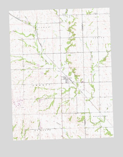
Emmett, KS USGS Topographic Map
Click on map above to begin viewing in our Map Viewer.

This topographic map contains these locations and features:
Feature Name Type Latitude Longitude GNIS ID View Map
AikinsPopulated PlaceN39.3681°W96.1164°484771View Map
Bartlett CreekStreamN39.3189°W96.0592°476125View Map
Big Noxie CreekStreamN39.3689°W96.0553°476126View Map
City of EmmettCivilN39.3072°W96.0573°2394690View Map
EmmettPopulated PlaceN39.3072°W96.0561°476257View Map
Emmett Grade SchoolSchoolN39.3081°W96.0580°2506369View Map
Emmett Post OfficePost OfficeN39.3076°W96.0563°2693710View Map
Emmett United Methodist ChurchChurchN39.3100°W96.0588°2689406View Map
Holy Cross CemeteryCemeteryN39.2741°W96.0474°476259View Map
Holycross (historical)LocaleN39.2747°W96.0447°481903View Map
Humdinger Trailer ParkPopulated PlaceN39.3051°W96.0554°2694100View Map
Illinois CreekStreamN39.2664°W96.0155°476256View Map
Jeffrey Energy CenterBuildingN39.2853°W96.1164°2129057View Map
Little Cross CreekStreamN39.2842°W96.0350°476255View Map
Little Noxie CreekStreamN39.3625°W96.0542°476124View Map
Long BranchStreamN39.3150°W96.0230°476254View Map
Mount Olive CemeteryCemeteryN39.3694°W96.0156°2673274View Map
Mount Olive ChurchChurchN39.3694°W96.0166°476253View Map
Pottawatomie County Fire District 8 EmmettBuildingN39.3070°W96.0557°2111738View Map
Saint ClerePopulated PlaceN39.3692°W96.0558°484772View Map
Saint Clere CemeteryCemeteryN39.3629°W96.0624°476252View Map
St Mary's AirparkAirportN39.2696°W96.0621°2651091View Map
Township of EmmettCivilN39.3082°W96.1058°476250View Map
Township of Saint ClereCivilN39.3632°W96.1055°476122View Map

Note: Coordinates in the location and feature list above are referenced to NAD83 datum.


Copyright (C) 2008-2024 Ryan Niemi / Sunset Dynamics ... All Rights Reserved