TopoQuest Logo
Do you find TopoQuest useful?
Help keep TopoQuest running and adding new maps/features by donating!
Bitcoin:  19c7KJd3qBynnjoSw5npx9KScwjBe4ifkT
Litecoin:  LXs6TkuXGGXo1vDsWCkWVdjQX94eUKd6ui
Home View Maps Find Maps Find Places Resources & Links


Elma, Washington Topographic Map

USGS Map Title: Elma, WA
USGS Map MRC: 47123A4
DRG (GeoTIFF) Download: o47123a4.tif


Neighboring USGS Topographic Map Quads:


  Wynoochee Valley NE, WA  
47123B5
 

  Matlock, WA  
47123B4
 

  Nahwatzel Lake, WA  
47123B3
 

  Prices Peak, WA  
47123A5
 

  Elma, WA  
47123A4
 

  McCleary, WA  
47123A3
 

  Montesano, WA  
46123H5
 

  South Elma, WA  
46123H4
 

  Malone, WA  
46123H3


Map MRC Location:

N48°
W124°
N48°
W123°
H8 H7 H6 H5 H4 H3 H2 H1
G8 G7 G6 G5 G4 G3 G2 G1
F8 F7 F6 F5 F4 F3 F2 F1
E8 E7 E6 E5 E4 E3 E2 E1
D8 D7 D6 D5 D4 D3 D2 D1
C8 C7 C6 C5 C4 C3 C2 C1
B8 B7 B6 B5 B4 B3 B2 B1
A8 A7 A6 A5 A4 A3 A2 A1
N47°
W124°
N47°
W123°

Elma, WA USGS 1:24K Topographic Map Preview:
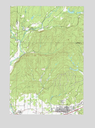
Elma, WA USGS Topographic Map
Click on map above to begin viewing in our Map Viewer.

This topographic map contains these locations and features:
Feature Name Type Latitude Longitude GNIS ID View Map
Bethany Baptist ChurchChurchN47.0039°W123.4553°2609454View Map
Christian Missionary AllianceChurchN47.0068°W123.4048°2609455View Map
Church of GodChurchN47.0032°W123.4079°2609456View Map
City of ElmaCivilN47.0070°W123.4050°2410431View Map
Comfort CreekStreamN47.0997°W123.4475°2126997View Map
Cook CreekStreamN47.0693°W123.4779°1504111View Map
Dear ValleyValleyN47.0688°W123.3758°2704675View Map
Decker CreekStreamN47.0959°W123.4746°1518573View Map
Dry Run CreekStreamN47.1004°W123.4452°1518978View Map
East Branch Newman CreekStreamN47.0320°W123.4449°1504627View Map
East Grays Harbor Learning Opportunity CenterSchoolN47.0034°W123.4097°2518417View Map
ElmaPopulated PlaceN47.0034°W123.4088°1512188View Map
Elma Adventist SchoolSchoolN47.0026°W123.4329°1515102View Map
Elma Catholic CemeteryCemeteryN47.0045°W123.4553°2605475View Map
Elma DivisionCivilN47.0321°W123.4214°1939502View Map
Elma Elementary SchoolSchoolN47.0042°W123.4339°1514166View Map
Elma Fire Department Station 88BuildingN47.0050°W123.4032°2606046View Map
Elma High SchoolSchoolN47.0032°W123.4137°1511885View Map
Elma Middle SchoolSchoolN47.0033°W123.4097°1514167View Map
Elma Police DepartmentBuildingN47.0051°W123.4038°2722033View Map
Elma Post OfficePost OfficeN47.0054°W123.4034°2606947View Map
Elma School District 68 OfficeSchoolN47.0032°W123.4344°2518506View Map
Elma Seventh Day Adventist ChurchChurchN47.0026°W123.4326°2608472View Map
Elma Timberland LibraryBuildingN47.0052°W123.4018°2610203View Map
Elma United Methodist ChurchChurchN47.0051°W123.4070°2608610View Map
Faith Lutheran ChurchChurchN47.0030°W123.4270°2609457View Map
First Baptist ChurchChurchN47.0041°W123.4081°2609458View Map
Grace Community ChurchChurchN47.0042°W123.4069°2609459View Map
Grays Harbor County FairgroundsLocaleN47.0129°W123.3790°1514196View Map
Grays Harbor Fire District 5 Station 53 SatsopBuildingN47.0062°W123.4616°2619722View Map
Hatchery GrangeLocaleN47.0998°W123.4735°1505416View Map
Henson CreekStreamN47.0073°W123.4902°1513012View Map
Horse PrairieFlatN47.1018°W123.4593°1505612View Map
Hunters PrairieFlatN47.0034°W123.4535°1510528View Map
Hunters Prairie SchoolSchoolN47.0020°W123.4488°1505676View Map
Ladysmith ParkParkN47.0084°W123.4115°1514260View Map
Lighthouse Baptist ChurchChurchN47.0038°W123.4061°2609460View Map
Maranatha ChurchChurchN47.0048°W123.4131°2609461View Map
Masonic CemeteryCemeteryN47.0023°W123.4346°2605476View Map
McDonald CreekStreamN47.0151°W123.3890°1513020View Map
Middle Branch Newman CreekStreamN47.0320°W123.4449°1509710View Map
Middle Fork Satsop RiverStreamN47.0837°W123.4849°1523086View Map
Murry ParkParkN47.0084°W123.4104°1514284View Map
Northwest Life CenterChurchN47.0057°W123.4046°2609462View Map
Oak Acres Mobile Home ParkPopulated PlaceN47.0047°W123.4606°2607186View Map
Oaks Ridge Golf CourseLocaleN47.0015°W123.4621°1533070View Map
Oaksridge Golf CourseLocaleN47.0007°W123.4554°1510527View Map
Oddfellow CemeteryCemeteryN47.0106°W123.3824°2605477View Map
Saint Joseph's Catholic ChurchChurchN47.0032°W123.4068°2609463View Map
Saint Luke's Episcopal ChurchChurchN47.0048°W123.4097°2609464View Map
SatsopPopulated PlaceN47.0032°W123.4835°1512643View Map
Satsop Census Designated PlaceCensusN47.0223°W123.4737°2409287View Map
Satsop Elementary SchoolSchoolN47.0032°W123.4805°1515104View Map
Satsop Post OfficePost OfficeN47.0023°W123.4833°2607014View Map
Satsop School District 104 OfficeSchoolN47.0034°W123.4805°2518505View Map
Schafer State ParkParkN47.0956°W123.4652°1508146View Map
Summit Pacific Medical CenterHospitalN47.0070°W123.3918°1510470View Map
The Church of Jesus Christ of Latter Day SaintsChurchN47.0081°W123.3900°2609465View Map
West Branch Newman CreekStreamN47.0376°W123.4488°1509385View Map

Note: Coordinates in the location and feature list above are referenced to NAD83 datum.


Copyright (C) 2008-2024 Ryan Niemi / Sunset Dynamics ... All Rights Reserved