TopoQuest Logo
Do you find TopoQuest useful?
Help keep TopoQuest running and adding new maps/features by donating!
Bitcoin:  19c7KJd3qBynnjoSw5npx9KScwjBe4ifkT
Litecoin:  LXs6TkuXGGXo1vDsWCkWVdjQX94eUKd6ui
Home View Maps Find Maps Find Places Resources & Links


Edgerton, Missouri Topographic Map

USGS Map Title: Edgerton, MO
USGS Map MRC: 39094E6
DRG (GeoTIFF) Download: o39094e6.tif


Neighboring USGS Topographic Map Quads:


  Saint Joseph South, MO  
39094F7
 

  Agency, MO  
39094F6
 

  Hemple, MO  
39094F5
 

  Dearborn, MO  
39094E7
 

  Edgerton, MO  
39094E6
 

  Gower, MO  
39094E5
 

  Tracy, MO  
39094D7
 

  Camden Point, MO  
39094D6
 

  Smithville, MO  
39094D5


Map MRC Location:

N40°
W95°
N40°
W94°
H8 H7 H6 H5 H4 H3 H2 H1
G8 G7 G6 G5 G4 G3 G2 G1
F8 F7 F6 F5 F4 F3 F2 F1
E8 E7 E6 E5 E4 E3 E2 E1
D8 D7 D6 D5 D4 D3 D2 D1
C8 C7 C6 C5 C4 C3 C2 C1
B8 B7 B6 B5 B4 B3 B2 B1
A8 A7 A6 A5 A4 A3 A2 A1
N39°
W95°
N39°
W94°

Edgerton, MO USGS 1:24K Topographic Map Preview:
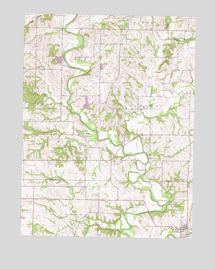
Edgerton, MO USGS Topographic Map
Click on map above to begin viewing in our Map Viewer.

This topographic map contains these locations and features:
Feature Name Type Latitude Longitude GNIS ID View Map
Arnoldsville School (historical)SchoolN39.5422°W94.7477°746556View Map
Belcher BranchStreamN39.5711°W94.7150°713886View Map
Benner LakeLakeN39.5567°W94.7028°713947View Map
Brinton CemeteryCemeteryN39.6117°W94.7400°714713View Map
Bruce School (historical)SchoolN39.5422°W94.6950°747068View Map
Burnett School (historical)SchoolN39.5944°W94.6316°746558View Map
Cantrell DamDamN39.5850°W94.7402°761041View Map
Cantrell LakeReservoirN39.5858°W94.7406°761042View Map
Castile CreekStreamN39.5483°W94.6616°730068View Map
Chestnut BranchStreamN39.5083°W94.7091°715772View Map
City of EdgertonCivilN39.5022°W94.6290°2394619View Map
Crabapple BranchStreamN39.5897°W94.6569°716440View Map
Davis ChapelChurchN39.5233°W94.6950°716723View Map
DeMoss BranchStreamN39.5458°W94.6588°716760View Map
EdgertonPopulated PlaceN39.5050°W94.6333°717400View Map
Edgerton - Trimble Fire Protection District Station 1BuildingN39.5046°W94.6310°2621584View Map
Edgerton Post OfficePost OfficeN39.5060°W94.6315°2782797View Map
Frazier BranchStreamN39.6053°W94.6533°718184View Map
Frazier CemeteryCemeteryN39.6169°W94.6755°718186View Map
Frazier ChurchChurchN39.6139°W94.6761°730101View Map
Gamble LakeLakeN39.5177°W94.6648°718325View Map
Grant LakeReservoirN39.6081°W94.7243°760277View Map
Grant Lake Dam - NorthDamN39.6167°W94.7236°762781View Map
Grant Lake Dam - SouthDamN39.6067°W94.7236°760276View Map
Hebron CemeteryCemeteryN39.5850°W94.6569°719329View Map
Hebron Church (historical)ChurchN39.5792°W94.6569°746559View Map
Holland BranchStreamN39.5039°W94.6766°719708View Map
Jenkins BranchStreamN39.5858°W94.6294°720289View Map
KSFT-FM (St Joseph)TowerN39.5014°W94.7366°759150View Map
Malden CreekStreamN39.5706°W94.6633°721774View Map
Matheys Mill (historical)LocaleN39.5511°W94.6761°746561View Map
Maupin CemeteryCemeteryN39.5205°W94.7397°721987View Map
McGauhey SchoolSchoolN39.6183°W94.7405°746551View Map
Middleton DamDamN39.5983°W94.6702°760518View Map
Middleton LakeReservoirN39.5983°W94.6702°760519View Map
Mitchell BranchStreamN39.5208°W94.6430°722482View Map
Mount Pleasant CemeteryCemeteryN39.5650°W94.7458°723195View Map
New Frame Church (historical)ChurchN39.5644°W94.7463°746555View Map
North Platte Intermediate SchoolSchoolN39.5063°W94.6370°2545134View Map
Number 6 CemeteryCemeteryN39.5753°W94.6900°755343View Map
Phelps School (historical)SchoolN39.5061°W94.7408°746557View Map
Platte RiverPopulated PlaceN39.5503°W94.6958°740178View Map
Rising Sun SchoolSchoolN39.5583°W94.6286°746560View Map
School Number 5SchoolN39.6092°W94.6800°746552View Map
School Number 6SchoolN39.5756°W94.6900°746553View Map
Sherwood School (historical)SchoolN39.5722°W94.7408°746554View Map
Tobin CemeteryCemeteryN39.5575°W94.6750°727685View Map
Township of JacksonCivilN39.5679°W94.7312°766340View Map
Township of PlatteCivilN39.5788°W94.6530°766343View Map
Union Mill CemeteryCemeteryN39.5175°W94.6394°728025View Map
Union Mill School (historical)SchoolN39.5186°W94.6388°746562View Map
Witts CemeteryCemeteryN39.5878°W94.6399°729023View Map
Wolfpen CreekStreamN39.6117°W94.6436°729078View Map

Note: Coordinates in the location and feature list above are referenced to NAD83 datum.


Copyright (C) 2008-2024 Ryan Niemi / Sunset Dynamics ... All Rights Reserved