TopoQuest Logo
Do you find TopoQuest useful?
Help keep TopoQuest running and adding new maps/features by donating!
Bitcoin:  19c7KJd3qBynnjoSw5npx9KScwjBe4ifkT
Litecoin:  LXs6TkuXGGXo1vDsWCkWVdjQX94eUKd6ui
Home View Maps Find Maps Find Places Resources & Links


Edenhouse, North Carolina Topographic Map

USGS Map Title: Edenhouse, NC
USGS Map MRC: 36076A6
DRG (GeoTIFF) Download: o36076a6.tif


Neighboring USGS Topographic Map Quads:


  Colerain, NC  
36076B7
 

  Valhalla, NC  
36076B6
 

  Center Hill, NC  
36076B5
 

  Merry Hill, NC  
36076A7
 

  Edenhouse, NC  
36076A6
 

  Edenton, NC  
36076A5
 

  Woodard, NC  
35076H7
 

  Westover, NC  
35076H6
 

  Roper North, NC  
35076H5


Map MRC Location:

N37°
W77°
N37°
W76°
H8 H7 H6 H5 H4 H3 H2 H1
G8 G7 G6 G5 G4 G3 G2 G1
F8 F7 F6 F5 F4 F3 F2 F1
E8 E7 E6 E5 E4 E3 E2 E1
D8 D7 D6 D5 D4 D3 D2 D1
C8 C7 C6 C5 C4 C3 C2 C1
B8 B7 B6 B5 B4 B3 B2 B1
A8 A7 A6 A5 A4 A3 A2 A1
N36°
W77°
N36°
W76°

Edenhouse, NC USGS 1:24K Topographic Map Preview:
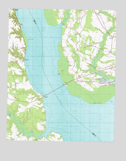
Edenhouse, NC USGS Topographic Map
Click on map above to begin viewing in our Map Viewer.

This topographic map contains these locations and features:
Feature Name Type Latitude Longitude GNIS ID View Map
AvocaPopulated PlaceN36.0027°W76.7116°1004838View Map
Ball Grey LandingLocaleN36.0046°W76.7122°1006441View Map
Bennett Mill PondReservoirN36.0568°W76.6647°999994View Map
Bennett Mill Pond DamDamN36.0568°W76.6647°999993View Map
Black Rock FisheryLocaleN36.0618°W76.7308°1006442View Map
BlackrockPopulated PlaceN36.0535°W76.7402°1019205View Map
Bowman BridgeBridgeN36.0710°W76.6486°1002684View Map
Capeharts FisheryLocaleN36.0029°W76.7058°1006443View Map
Chambers LandingLocaleN36.1002°W76.6874°1002687View Map
Chowan RiverStreamN36.0165°W76.6619°1025244View Map
Copper NeckCapeN36.0913°W76.6924°1002694View Map
Countryside Church of ChristChurchN36.0569°W76.6623°2505863View Map
EdenhousePopulated PlaceN36.0432°W76.7094°1004130View Map
Edenhouse PointCapeN36.0427°W76.7072°1025301View Map
Edenton National Fish HatcheryParkN36.0592°W76.6381°1004511View Map
Emperor LandingLocaleN36.0640°W76.6897°1020152View Map
First Assembly of God ChurchChurchN36.0565°W76.6425°2505816View Map
Freemans LandingLocaleN36.0127°W76.7363°1006440View Map
HancockPopulated PlaceN36.0993°W76.6286°986348View Map
Hermitage WharfLocaleN36.0863°W76.7283°986646View Map
Hoffman ChapelChurchN36.0854°W76.6302°1004310View Map
Lawrence LandingLocaleN36.0210°W76.7399°1006432View Map
Littledals Ferry Site (historical)LocaleN36.1235°W76.7430°1006431View Map
MacedoniaPopulated PlaceN36.1018°W76.6672°1025505View Map
Macedonia ChurchChurchN36.1002°W76.6669°1002692View Map
Mount Gould LandingPopulated PlaceN36.1235°W76.7430°1021545View Map
Oxley Hill ChurchChurchN36.0396°W76.7391°1004129View Map
Peterson ChurchChurchN36.0015°W76.7413°1004128View Map
Pollock SwampStreamN36.0707°W76.6483°1025623View Map
Reedy PointCapeN36.0360°W76.6549°993206View Map
Rockyhock CreekStreamN36.1113°W76.6886°993633View Map
Salmon CreekStreamN36.0104°W76.6997°1025674View Map
Steele LandingLocaleN36.1096°W76.7363°1022784View Map
Todd LandingLocaleN36.0257°W76.7427°1006420View Map
Township 1-EdentonCivilN36.0756°W76.6320°1026550View Map
Wildcat BridgeBridgeN36.0882°W76.6413°1002683View Map
Wildcat ChurchChurchN36.0927°W76.6502°1004309View Map
Wilder LandingLocaleN36.0807°W76.6886°1002693View Map
Willifords LandingLocaleN36.0218°W76.7486°1023263View Map
Willis LandingLocaleN36.0029°W76.7247°1006419View Map
Willow BranchStreamN36.0777°W76.7299°1025806View Map
Willow Branch LandingLocaleN36.0763°W76.7305°1023268View Map

Note: Coordinates in the location and feature list above are referenced to NAD83 datum.


Copyright (C) 2008-2024 Ryan Niemi / Sunset Dynamics ... All Rights Reserved