TopoQuest Logo
Do you find TopoQuest useful?
Help keep TopoQuest running and adding new maps/features by donating!
Bitcoin:  19c7KJd3qBynnjoSw5npx9KScwjBe4ifkT
Litecoin:  LXs6TkuXGGXo1vDsWCkWVdjQX94eUKd6ui
Home View Maps Find Maps Find Places Resources & Links


Eddyville, Oregon Topographic Map

USGS Map Title: Eddyville, OR
USGS Map MRC: 44123F7
DRG (GeoTIFF) Download: o44123f7.tif


Neighboring USGS Topographic Map Quads:


  Mowrey Landing, OR  
44123G8
 

  Euchre Mountain, OR  
44123G7
 

  Valsetz, OR  
44123G6
 

  Toledo North, OR  
44123F8
 

  Eddyville, OR  
44123F7
 

  Nortons, OR  
44123F6
 

  Toledo South, OR  
44123E8
 

  Elk City, OR  
44123E7
 

  Harlan, OR  
44123E6


Map MRC Location:

N45°
W124°
N45°
W123°
H8 H7 H6 H5 H4 H3 H2 H1
G8 G7 G6 G5 G4 G3 G2 G1
F8 F7 F6 F5 F4 F3 F2 F1
E8 E7 E6 E5 E4 E3 E2 E1
D8 D7 D6 D5 D4 D3 D2 D1
C8 C7 C6 C5 C4 C3 C2 C1
B8 B7 B6 B5 B4 B3 B2 B1
A8 A7 A6 A5 A4 A3 A2 A1
N44°
W124°
N44°
W123°

Eddyville, OR USGS 1:24K Topographic Map Preview:
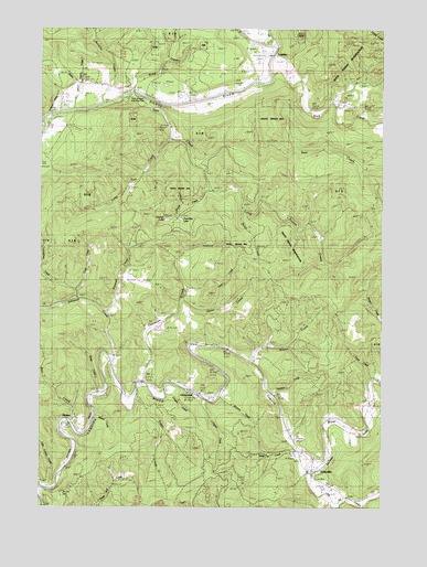
Eddyville, OR USGS Topographic Map
Click on map above to begin viewing in our Map Viewer.

This topographic map contains these locations and features:
Feature Name Type Latitude Longitude GNIS ID View Map
Adams CreekStreamN44.7351°W123.8637°1130803View Map
Baker CreekStreamN44.7290°W123.8671°1117154View Map
Bales CreekStreamN44.6737°W123.7509°1117204View Map
Bear CreekStreamN44.6473°W123.8671°1117370View Map
Bentilla CreekStreamN44.7307°W123.8557°1137937View Map
Bevens Quarry (historical)LocaleN44.6368°W123.8665°1166533View Map
ChitwoodPopulated PlaceN44.6548°W123.8226°1136148View Map
Chitwood CemeteryCemeteryN44.6543°W123.8143°1130810View Map
Chitwood Post Office (historical)Post OfficeN44.6548°W123.8226°1165049View Map
Cobb (historical)LocaleN44.6307°W123.8715°1166535View Map
Cook CreekStreamN44.6796°W123.8651°1119215View Map
Cougar CreekStreamN44.6543°W123.8312°1119373View Map
Crystal CreekStreamN44.6526°W123.8162°1119606View Map
Derrick LakeLakeN44.6998°W123.8302°1119875View Map
Eddy CemeteryCemeteryN44.6436°W123.7858°1156884View Map
Eddy CreekStreamN44.6404°W123.7837°1120387View Map
EddyvillePopulated PlaceN44.6346°W123.7765°1120389View Map
Eddyville CemeteryCemeteryN44.6326°W123.7742°1130937View Map
Eddyville Charter SchoolSchoolN44.6343°W123.7780°1162280View Map
Eddyville Post OfficePost OfficeN44.6373°W123.7758°1165197View Map
Eddyville School (historical)SchoolN44.6356°W123.7769°1162281View Map
Elk City CemeteryCemeteryN44.6291°W123.8675°1135165View Map
Haxel CreekStreamN44.6796°W123.8259°1121681View Map
Hayes CreekStreamN44.6626°W123.7993°1121698View Map
Klamath CreekStreamN44.6754°W123.8529°1122792View Map
Little Carlisle CreekStreamN44.6310°W123.8748°1123148View Map
Little Elk (historical)Populated PlaceN44.6451°W123.7854°1166536View Map
Little Elk CreekStreamN44.6346°W123.7768°1123188View Map
LogsdenPopulated PlaceN44.7432°W123.7943°1136494View Map
Logsden Post OfficePost OfficeN44.7427°W123.7933°1165556View Map
Long Prairie CreekStreamN44.7146°W123.8182°1123446View Map
Long Tom CreekStreamN44.7212°W123.8298°1123451View Map
Mann CreekStreamN44.7023°W123.8040°1123726View Map
Martin CreekStreamN44.6487°W123.8579°1123807View Map
Miami Quarry Company (historical)LocaleN44.6490°W123.8568°1166537View Map
Mill CreekStreamN44.7457°W123.7937°1146242View Map
Morrison (historical)Populated PlaceN44.6448°W123.8629°1166538View Map
Native American Church of SiletzChurchN44.7489°W123.7936°2508159View Map
Orton BridgeBridgeN44.7423°W123.7926°1125048View Map
Peterson CreekStreamN44.6537°W123.7918°1125320View Map
PioneerPopulated PlaceN44.6479°W123.8701°1136629View Map
Pioneer City (historical)Populated PlaceN44.6401°W123.8637°1135660View Map
Pioneer City Post Office (historical)Post OfficeN44.6401°W123.8637°1165791View Map
Pioneer Lumber Company (historical)LocaleN44.6310°W123.8709°1166539View Map
Pioneer Post Office (historical)Post OfficeN44.6479°W123.8701°1165792View Map
Riverside VFW CemeteryCemeteryN44.7229°W123.8693°1135195View Map
Rock CreekStreamN44.7376°W123.7932°1126160View Map
Sam CreekStreamN44.7310°W123.8523°1126535View Map
Sams Creek Boat LaunchLocaleN44.7325°W123.8407°2668416View Map
Satter CreekStreamN44.6762°W123.8123°1127775View Map
Scott CreekStreamN44.7337°W123.8448°1126685View Map
Siletz Rural Fire Protection District Logsden SubstationBuildingN44.7429°W123.7895°2576976View Map
Simpson CreekStreamN44.6632°W123.8523°1126994View Map
Sloop CreekStreamN44.6540°W123.8571°1127091View Map
Spring BrookStreamN44.6637°W123.8507°1130811View Map
Thayer CreekStreamN44.7143°W123.8179°1127947View Map
Thornton CreekStreamN44.6576°W123.8398°1128053View Map
Toledo Fire and Rescue Department Station 43BuildingN44.6355°W123.7768°2577111View Map
Trapp CreekStreamN44.6529°W123.8426°1128206View Map
Trembley LakeLakeN44.7000°W123.8251°1128216View Map
Trout CreekStreamN44.6590°W123.7548°1128239View Map
Twentythree CreekStreamN44.6818°W123.8659°1128335View Map
Twin Bridges County ParkParkN44.7326°W123.8432°2022207View Map
Twin Bridges Park Boat RampLocaleN44.7325°W123.8407°2668305View Map
Whitney CreekStreamN44.6540°W123.8109°1129022View Map
WOW Log PondReservoirN44.6387°W123.7826°1130801View Map

Note: Coordinates in the location and feature list above are referenced to NAD83 datum.


Copyright (C) 2008-2024 Ryan Niemi / Sunset Dynamics ... All Rights Reserved