TopoQuest Logo
Do you find TopoQuest useful?
Help keep TopoQuest running and adding new maps/features by donating!
Bitcoin:  19c7KJd3qBynnjoSw5npx9KScwjBe4ifkT
Litecoin:  LXs6TkuXGGXo1vDsWCkWVdjQX94eUKd6ui
Home View Maps Find Maps Find Places Resources & Links


Eagle Springs, Texas Topographic Map

USGS Map Title: Eagle Springs, TX
USGS Map MRC: 31097C4
DRG (GeoTIFF) Download: o31097c4.tif


Neighboring USGS Topographic Map Quads:


  Oglesby, TX  
31097D5
 

  McGregor, TX  
31097D4
 

  South Bosque, TX  
31097D3
 

  Leon Junction, TX  
31097C5
 

  Eagle Springs, TX  
31097C4
 

  Moody, TX  
31097C3
 

  Bland, TX  
31097B5
 

  Moffat, TX  
31097B4
 

  Troy, TX  
31097B3


Map MRC Location:

N32°
W98°
N32°
W97°
H8 H7 H6 H5 H4 H3 H2 H1
G8 G7 G6 G5 G4 G3 G2 G1
F8 F7 F6 F5 F4 F3 F2 F1
E8 E7 E6 E5 E4 E3 E2 E1
D8 D7 D6 D5 D4 D3 D2 D1
C8 C7 C6 C5 C4 C3 C2 C1
B8 B7 B6 B5 B4 B3 B2 B1
A8 A7 A6 A5 A4 A3 A2 A1
N31°
W98°
N31°
W97°

Eagle Springs, TX USGS 1:24K Topographic Map Preview:
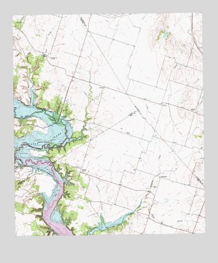
Eagle Springs, TX USGS Topographic Map
Click on map above to begin viewing in our Map Viewer.

This topographic map contains these locations and features:
Feature Name Type Latitude Longitude GNIS ID View Map
Alexander CemeteryCemeteryN31.3207°W97.3806°1350972View Map
Brewster CreekStreamN31.2552°W97.4417°1352861View Map
Buckhorn CemeteryCemeteryN31.2763°W97.4533°1353156View Map
Eagle SpringsSpringN31.3518°W97.4786°1356543View Map
Eagle Springs CemeteryCemeteryN31.3504°W97.4761°1356544View Map
Horseshoe BendBendN31.2968°W97.4903°1385380View Map
Horseshoe Bend Wildlife Management AreaParkN31.2974°W97.4864°1385381View Map
Iron Bridge ParkParkN31.2791°W97.4700°1360029View Map
Iron Bridge Wildlife Management AreaParkN31.3013°W97.4961°1385382View Map
Meador GrovePopulated PlaceN31.2854°W97.4570°1380170View Map
Moody-Leon CemeteryCemeteryN31.2768°W97.4536°1385383View Map
Moody-Leon ChurchChurchN31.2882°W97.4564°1363084View Map
Mother Neff ChurchChurchN31.3204°W97.4683°1363209View Map
Mother Neff State ParkParkN31.3238°W97.4700°1363210View Map
Mother Neff State Park TrailTrailN31.3154°W97.4717°2033357View Map
Mount Zion CemeteryCemeteryN31.3227°W97.4028°1363336View Map
Onion CreekStreamN31.3421°W97.4889°1364559View Map
Payne BranchStreamN31.2680°W97.4170°1364909View Map
StampedePopulated PlaceN31.2821°W97.4039°1380598View Map
Station CreekStreamN31.3238°W97.4883°1369135View Map
Station Creek CemeteryCemeteryN31.3704°W97.4942°1369136View Map
Stockton ChapelChurchN31.3068°W97.4242°1369227View Map
Tick Hill AirfieldAirportN31.3105°W97.4847°2676584View Map
WhitsonPopulated PlaceN31.3338°W97.4406°1380776View Map

Note: Coordinates in the location and feature list above are referenced to NAD83 datum.


Copyright (C) 2008-2024 Ryan Niemi / Sunset Dynamics ... All Rights Reserved