TopoQuest Logo
Do you find TopoQuest useful?
Help keep TopoQuest running and adding new maps/features by donating!
Bitcoin:  19c7KJd3qBynnjoSw5npx9KScwjBe4ifkT
Litecoin:  LXs6TkuXGGXo1vDsWCkWVdjQX94eUKd6ui
Home View Maps Find Maps Find Places Resources & Links


Eagle Nest Mountain, Arizona Topographic Map

USGS Map Title: Eagle Nest Mountain, AZ
USGS Map MRC: 35112D5
DRG (GeoTIFF) Download: o35112d5.tif


Neighboring USGS Topographic Map Quads:


  Bishop Lake, AZ  
35112E6
 

  Howard Spring, AZ  
35112E5
 

  Red Hill Ranch, AZ  
35112E4
 

  Mount Floyd, AZ  
35112D6
 

  Eagle Nest Mountain, AZ  
35112D5
 

  Stanford Tank, AZ  
35112D4
 

  Crookton, AZ  
35112C6
 

  Horse Trap Mesa, AZ  
35112C5
 

  Fitzgerald Hill, AZ  
35112C4


Map MRC Location:

N36°
W113°
N36°
W112°
H8 H7 H6 H5 H4 H3 H2 H1
G8 G7 G6 G5 G4 G3 G2 G1
F8 F7 F6 F5 F4 F3 F2 F1
E8 E7 E6 E5 E4 E3 E2 E1
D8 D7 D6 D5 D4 D3 D2 D1
C8 C7 C6 C5 C4 C3 C2 C1
B8 B7 B6 B5 B4 B3 B2 B1
A8 A7 A6 A5 A4 A3 A2 A1
N35°
W113°
N35°
W112°

Eagle Nest Mountain, AZ USGS 1:24K Topographic Map Preview:
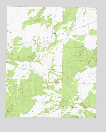
Eagle Nest Mountain, AZ USGS Topographic Map
Click on map above to begin viewing in our Map Viewer.

This topographic map contains these locations and features:
Feature Name Type Latitude Longitude GNIS ID View Map
Big Bill TankReservoirN35.4144°W112.5055°26239View Map
Big Freeman TankReservoirN35.4920°W112.5581°37644View Map
Boundary TankReservoirN35.4144°W112.5164°26666View Map
Chunin TankReservoirN35.4919°W112.5582°42660View Map
Eagle Nest MountainSummitN35.3883°W112.5155°28722View Map
Eagle Nest Railroad StationBuildingN35.3864°W112.5499°37766View Map
Flagstone TankReservoirN35.4237°W112.5737°29054View Map
Gas Line TankReservoirN35.3824°W112.5900°29271View Map
Goldtrap RanchLocaleN35.3858°W112.5441°29405View Map
Goldtrap TankReservoirN35.3865°W112.5437°37818View Map
H Ranch TankReservoirN35.4698°W112.5615°29646View Map
Horse TankReservoirN35.3989°W112.5175°2091484View Map
Joy TankReservoirN35.4004°W112.5244°30627View Map
Limestone TankReservoirN35.4663°W112.5853°30994View Map
Little Bill TankReservoirN35.4557°W112.5184°31031View Map
Mike TankReservoirN35.3847°W112.5024°31848View Map
Oliver TankReservoirN35.4844°W112.5849°32524View Map
Phil McGill TankReservoirN35.4350°W112.5119°32844View Map
Railroad TankReservoirN35.3933°W112.5233°2091483View Map
Russell QuarryMineN35.4117°W112.5221°38047View Map
Russell TankReservoirN35.3933°W112.5439°2091481View Map
Seven Ranch TankReservoirN35.4296°W112.6018°34276View Map
Ship Dam TankReservoirN35.4883°W112.5281°42655View Map
Strawberry TankReservoirN35.3883°W112.5267°2091482View Map
White TankReservoirN35.4755°W112.5088°36116View Map

Note: Coordinates in the location and feature list above are referenced to NAD83 datum.


Copyright (C) 2008-2024 Ryan Niemi / Sunset Dynamics ... All Rights Reserved