TopoQuest Logo
Do you find TopoQuest useful?
Help keep TopoQuest running and adding new maps/features by donating!
Bitcoin:  19c7KJd3qBynnjoSw5npx9KScwjBe4ifkT
Litecoin:  LXs6TkuXGGXo1vDsWCkWVdjQX94eUKd6ui
Home View Maps Find Maps Find Places Resources & Links


Eagle Lake, Maine Topographic Map

USGS Map Title: Eagle Lake, ME
USGS Map MRC: 47068A5
DRG (GeoTIFF) Download: o47068a5.tif


Neighboring USGS Topographic Map Quads:


  Wheelock, ME  
47068B6
 

  Fort Kent South, ME  
47068B5
 

  Daigle, ME  
47068B4
 

  Wallagrass Lakes, ME  
47068A6
 

  Eagle Lake, ME  
47068A5
 

  Square Lake West, ME  
47068A4
 

  Island Pond, ME  
46068H6
 

  Winterville, ME  
46068H5
 

  McClusky Lake, ME  
46068H4


Map MRC Location:

N48°
W69°
N48°
W68°
H8 H7 H6 H5 H4 H3 H2 H1
G8 G7 G6 G5 G4 G3 G2 G1
F8 F7 F6 F5 F4 F3 F2 F1
E8 E7 E6 E5 E4 E3 E2 E1
D8 D7 D6 D5 D4 D3 D2 D1
C8 C7 C6 C5 C4 C3 C2 C1
B8 B7 B6 B5 B4 B3 B2 B1
A8 A7 A6 A5 A4 A3 A2 A1
N47°
W69°
N47°
W68°

Eagle Lake, ME USGS 1:24K Topographic Map Preview:
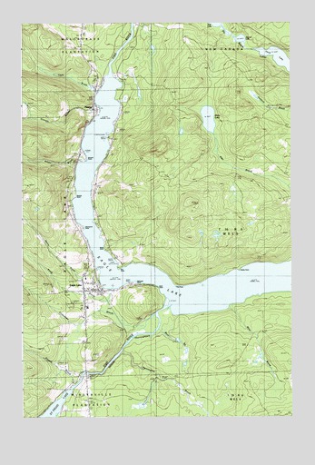
Eagle Lake, ME USGS Topographic Map
Click on map above to begin viewing in our Map Viewer.

This topographic map contains these locations and features:
Feature Name Type Latitude Longitude GNIS ID View Map
Bear BrookStreamN47.0289°W68.5620°561814View Map
Belanger PointCapeN47.0431°W68.5728°562006View Map
Blake LakeLakeN47.0946°W68.5380°562552View Map
Boyles PointCapeN47.0695°W68.6012°562825View Map
Brown BrookStreamN47.0814°W68.5962°563040View Map
Browns PointCapeN47.0814°W68.5962°563082View Map
Camp CozyLocaleN47.0434°W68.5423°563392View Map
Carnes CampLocaleN47.0920°W68.5362°563578View Map
Clark BrookStreamN47.1034°W68.5889°564026View Map
Clover Hill CampgroundLocaleN47.0487°W68.5800°1910302View Map
Devoe BrookStreamN47.0473°W68.5906°565078View Map
Dry PointCapeN47.0473°W68.5795°565320View Map
Dubay PointCapeN47.0470°W68.5239°565326View Map
Duck PointCapeN47.0403°W68.5628°565347View Map
Eagle LakePopulated PlaceN47.0400°W68.5895°565495View Map
Eagle Lake Census Designated PlaceCensusN47.0347°W68.5888°2583556View Map
Eagle Lake Elementary Junior High SchoolSchoolN47.0441°W68.5954°1910320View Map
Eagle Lake Fire DepartmentBuildingN47.0433°W68.6009°2552745View Map
Eagle Lake Post OfficePost OfficeN47.0412°W68.5971°1910322View Map
Gilmore BrookStreamN47.0989°W68.5887°566807View Map
Lake View SchoolSchoolN47.0834°W68.5853°569317View Map
Longfellow CemeteryCemeteryN47.0045°W68.5945°2678689View Map
Longfellow SchoolSchoolN47.0050°W68.5953°570334View Map
Longfellow SchoolSchoolN47.0264°W68.5956°570335View Map
Miller BrookStreamN47.0359°W68.5278°571368View Map
Nadeau ThoroughfareChannelN47.0145°W68.5970°572037View Map
Oak PointCapeN47.0425°W68.5534°572628View Map
Pennington BrookStreamN47.0212°W68.5792°573167View Map
Pinette BrookStreamN47.0106°W68.6012°573417View Map
PlaistedPopulated PlaceN47.0978°W68.5903°573469View Map
Plaisted Post OfficePost OfficeN47.0978°W68.5884°1910555View Map
Pond BrookStreamN47.0412°W68.5834°573588View Map
Roys PointCapeN47.0567°W68.5892°574565View Map
Saint Elizabeth SchoolSchoolN47.1187°W68.5714°574702View Map
Saint Marys CemeteryCemeteryN47.0319°W68.5977°2678386View Map
Saint Marys ChurchChurchN47.0320°W68.5962°574744View Map
Saint Marys RectoryBuildingN47.0320°W68.5962°1910616View Map
Saucier CampLocaleN47.0656°W68.5628°574935View Map
Second LakeLakeN47.1199°W68.5231°575197View Map
Seymours PointCapeN47.0598°W68.5975°575263View Map
Sly Brook LakesLakeN47.1135°W68.5046°575558View Map
Smith SchoolSchoolN47.0870°W68.5987°575646View Map
Stetson SchoolSchoolN47.0578°W68.5981°576311View Map
T16 R6 WELSCivilN47.0661°W68.5041°1987219View Map
Thibadeau BrookStreamN47.0331°W68.5634°576943View Map
Third LakeLakeN47.1123°W68.5045°576959View Map
Wallagrass StationLocaleN47.1050°W68.5914°577808View Map
Wiles CampLocaleN47.0417°W68.5645°578482View Map

Note: Coordinates in the location and feature list above are referenced to NAD83 datum.


Copyright (C) 2008-2024 Ryan Niemi / Sunset Dynamics ... All Rights Reserved